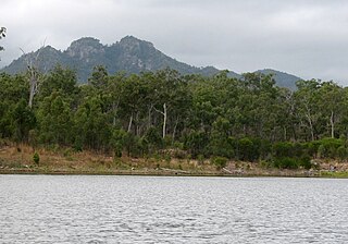
Castle Tower is a national park in the Gladstone Region, Queensland, Australia.

Mitchell Highway is an outback state highway located in the central and south western regions of Queensland and the northern and central western regions of New South Wales in Australia. The southern part of Mitchell Highway forms part of the National Highway A32 B71 corridor, which stretches from Sydney to Brisbane via Dubbo. Mitchell Highway also forms part of the shortest route between Sydney and Darwin, via Bourke and Mount Isa, making it an important road link for the transport of passengers and freight for regional New South Wales and Queensland. The highway is a part of route Alternative A2 between Augathella and Charleville, route A71 and B71 between Charleville and Nyngan, and part of route A32 between Nyngan and Bathurst.

The Mitchell River is a river in Far North Queensland, Australia. The river rises on the Atherton Tableland about 50 kilometres (31 mi) northwest of Cairns and flows about 750 kilometres (470 mi) northwest across Cape York Peninsula from Mareeba to the Gulf of Carpentaria.

The Thomson River is a perennial river that forms part of the Lake Eyre Basin, situated in the central west and western regions of Queensland, Australia. Much of the course of the river comprises a series of narrow channels synonymous with the Channel Country and the Galilee subregion.

The Outback Highway or Outback Way is a series of roads and dirt tracks linking Laverton, Western Australia and Winton, Queensland. At 2,719 km (1,690 mi), it crosses Central Australia, passing through Western Australia, the Northern Territory and Queensland.
A pastoral lease, sometimes called a pastoral run, is an arrangement used in both Australia and New Zealand where government-owned Crown land is leased out to graziers for the purpose of livestock grazing on rangelands.
A selective school is a school that admits students on the basis of some sort of selection criteria, usually academic. The term may have different connotations in different systems and is the opposite of a comprehensive school, which accepts all students, regardless of aptitude.

The states and territories are administrative divisions in Australia, ruled by regional governments that constitute the level of governance between the federal government and local governments. States are self-governing polities with incomplete sovereignty and their own constitutions, legislatures, departments, and certain civil authorities that administer and deliver most public policies and programs. Territories can be autonomous and administer local policies and programs much like the states in practice, but are still legally subordinate to the federal government.
The Gazetteer of Australia is an index or dictionary of the location and spelling of geographical names across Australia. Geographic names include towns, suburbs and roads, plus geographical features such as hills, rivers, and lakes.

Wandoan is a town and locality in the Western Downs Region, Queensland, Australia. It was formerly known as Juandah. It is on the Leichhardt Highway about halfway between Taroom and Miles and is the centre for the local cattle industry. In the 2016 census, Wandoan had a population of 566 people.

Calicium is a genus of leprose lichens. It is in the family Caliciaceae.

Calicium abietinum, commonly known as fir pin or black stubble, is a crustose lichen that is found growing on trees throughout much of the world.
Calicium chlorosporum is a crustose lichen that is found growing on trees throughout much of the world.
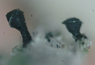
Calicium glaucellum is a crustose lichen that is found growing on trees throughout much of the world.
Calicium laevigatum is a crustose lichen that is found growing on trees in the South West region of Western Australia.
Calicium lenticulare is a crustose lichen that is found growing on trees in the South West region of Western Australia.

Calicium salicinum is a crustose lichen that is found growing on trees in the South West region of Western Australia.
Calicium tricolor is a crustose lichen that is found growing on trees in the South West region of Western Australia.
Calicium victorianum is a crustose lichen that is found growing on trees and wooden materials.