California, Derby

Last updated

California
Derby terrace.jpg
Terraced houses in California.
Derbyshire UK location map.svg
Red pog.svg
California
Location within Derbyshire
OS grid reference SK341356
District
Shire county
Region
Country England
Sovereign state United Kingdom
Post town DERBY
Postcode district DE22
Police Derbyshire
Fire Derbyshire
Ambulance East Midlands
List of places
UK
England
Derbyshire
52°55′01″N1°29′38″W / 52.917°N 1.494°W / 52.917; -1.494 Coordinates: 52°55′01″N1°29′38″W / 52.917°N 1.494°W / 52.917; -1.494

California is an inner-city area of Derby to the south west of the city in between the A516 (Uttoxeter New Road) and A5250 (Burton Road). It is part of the Abbey ward.

Contents

History

The name California first appears on local maps from the 1880s, and may derive from the California Gold Rush of 1849, but the reason for such an association is unclear. [1]

Amenities

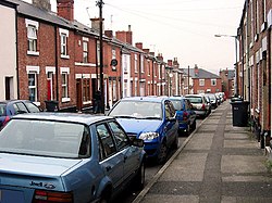
The area is home to Bemrose Community School and some of the halls of residence for the University of Derby. There are two playing fields nearby; Stockbrook Park and Rykneld Recreation Ground ('The Rec'). Many of the houses in the area are red brick terraces and there are many pubs nearby including the Junction Tavern, the Rowditch and the Bedford Arms.

Towards the south of the area is neighbouring Rowditch district which is home to a large student population. Whilst many of the nearby inner-suburbs of Derby including the West End and Morley Estate have undergone recent gentrification, California has largely retained its traditional character.

Related Research Articles

Suburb Human settlement that is part of/or near to a larger city or town

A suburb is an area outside of a principal city of a metropolitan area, which may include commercial and mixed-use, but is primarily a residential area. A suburb can exist either as part of a larger city/urban area or as a separate political entity. The name describes an area which is not as densely populated as an inner city, yet more densely populated than a rural area in the countryside. In many metropolitan areas, suburbs exist as separate residential communities within commuting distance of a city Suburbs can have their own political or legal jurisdiction, especially in the United States, but this is not always the case, especially in the United Kingdom, where most suburbs are located within the administrative boundaries of cities. In most English-speaking countries, suburban areas are defined in contrast to central or inner city areas, but in Australian English and South African English, suburb has become largely synonymous with what is called a "neighborhood" in other countries, and the term encompasses inner city areas.

Camperdown, New South Wales Suburb of Sydney, New South Wales, Australia

Camperdown is an inner western suburb of Sydney, in the state of New South Wales, Australia. Camperdown is located 4 kilometres south-west of the Sydney central business district and is part of the Inner West region. Camperdown lies across the local government areas of the City of Sydney and Inner West Council.

Normanton, Derby Human settlement in England

Normanton is an inner city suburb and ward of the city of Derby in Derbyshire, England, situated approximately 2 miles (3.2 km) south of the city centre. Neighbouring suburbs include Littleover, Pear Tree, Rose Hill and Sunny Hill. The original village of Normanton-by-Derby, which now forms the southern part of the suburb, dates back to the medieval period. As the Normanton area became rapidly urbanised in the 19th century, the New Normanton area to the north was developed for housing, linking the old village to Derby, into which it was eventually absorbed. The area is characterised by high density late 19th century terraced housing in New Normanton and mid-20th century housing estates elsewhere, and has the most ethnically diverse population in Derby. The Normanton ward had a population of 17,071 in 2011.

South Melbourne, Victoria Suburb of Melbourne, Victoria, Australia

South Melbourne is an inner suburb of Melbourne, Australia, 3 km south of Melbourne's Central Business District (CBD). It is in the local government area of the City of Port Phillip. At the 2016 census, South Melbourne had a population of 10,920.

North Shore (Sydney) Region in New South Wales, Australia

The North Shore is a region within Northern Sydney, in the state of New South Wales, Australia. The term is customary, not legal or administrative, and in customary usage generally includes the suburbs located on the northern side of Sydney Harbour up to Hornsby, and between Middle Harbour and the Lane Cove River.

Inner West Region in New South Wales, Australia

The Inner West of Sydney is an area directly west of the Sydney central business district, New South Wales, Australia. The suburbs that make up the Inner West are predominantly located along the southern shore of Port Jackson, stretching south to the shores of the Cooks River. The western boundary of the Inner West is approximately the A3 arterial road, which divides the Inner West from the Greater Western Sydney region. The Inner West is much larger than the Inner West Council local government area. The Inner West roughly corresponds with the Parish of Petersham and Parish of Concord, two cadastral divisions used for land titles.

Leichhardt, New South Wales Suburb of Sydney, New South Wales, Australia

Leichhardt is a suburb in the Inner West of Sydney, in the state of New South Wales, Australia. Leichhardt is located 5 kilometres west of the Sydney central business district (CBD) and is the administrative centre for the local government area (LGA) of the Inner West Council. The suburb is bordered by Haberfield to the west, Annandale to the east, Lilyfield to the north and Petersham, Lewisham and Stanmore to the south.

Lilyfield, New South Wales Suburb of Sydney, New South Wales, Australia

Lilyfield is a suburb in the Inner West of Sydney, in the state of New South Wales, Australia. Lilyfield is located 6 kilometres west of the Sydney central business district, in the local government area of the Inner West Council.

Petersham, New South Wales Suburb of Sydney, New South Wales, Australia

Petersham is a suburb in the Inner West of Sydney, in the state of New South Wales, Australia. Petersham is located 6 kilometres south-west of the Sydney central business district, in the local government area of Inner West Council. Petersham is known for its extensive Portuguese commercial offerings, with many Portuguese businesses and restaurants, although only 156 (1.9%) of the population was actually born in Portugal.

Croydon, New South Wales Suburb of Sydney, New South Wales, Australia

Croydon is a suburb in the Inner West of Sydney, in the state of New South Wales, Australia. It is located 9 kilometres (5.6 mi) west of the Sydney central business district. Croydon is split between the two local government areas of Municipality of Burwood and the Inner West Council.

Dunedin is a city of 133,300 people in the South Island of New Zealand. The principal suburbs of Dunedin are as follows. Inner and outer suburbs are ordered by location, clockwise from the city centre, starting due north:

Suburbs of Johannesburg

The suburbs of Johannesburg are officially demarcated areas within the City of Johannesburg Metropolitan Municipality, South Africa. As in other Commonwealth countries, the term suburb refers to a "neighbourhood", although the term has a somewhat stronger meaning in South Africa as most "suburbs" have legally recognised borders and often separate postal codes. The municipal functions for the area, such as municipal policing and social services, are still managed by the city government.

Ultimo, New South Wales Suburb of Sydney, New South Wales, Australia

Ultimo is an inner-city suburb of Sydney, New South Wales, Australia.

Rozelle Suburb of Sydney, New South Wales, Australia

Rozelle is a suburb in the inner west of Sydney, in the state of New South Wales, Australia. It is located 4 kilometres west of the Sydney central business district, in the local government area of the Inner West Council.

Five Dock, New South Wales Suburb of Sydney, New South Wales, Australia

Five Dock is a suburb in the Inner West of Sydney, in the state of New South Wales, Australia. Five Dock is located 10 kilometres west of the Sydney central business district, in the local government area of the City of Canada Bay.

Guindy Neighborhood of Chennai, India

Guindy is one of the most important neighborhoods of Chennai, Tamil Nadu, India and is nicknamed as The Gateway to Chennai. The Kathipara junction where Anna Salai, Mount-Poonamallee Road, Inner Ring Road, 100 Feet Road or Jawaharlal Nehru Road, and GST Road meet here. It is one of the important nodal points of road traffic in the metropolitan area. It is also a commercial hub. Here is headquarters of Ashok Leyland This junction serves as the entry point to the city limits from the suburbs. It is surrounded by Saidapet in the North, Kotturpuram and Adyar towards the East, Velachery in the South, Adambakkam and Alandur in the South-West, St Thomas Mount in the West and Ekkatutthangal in the North-West. Guindy is home to many important landmarks in the city, the most famous amongst them being the Guindy National Park — the only National Park in the country within city limits. It also serves as a main hub for several small and medium scale industries. Transportation to/from the neighborhood is catered by Guindy railway station and Guindy metro station.

Chiswick, New South Wales Suburb of Sydney, New South Wales, Australia

Chiswick is a suburb in the Inner West of Sydney, in the state of New South Wales, Australia. It is located 9 kilometres west of the Sydney central business district in the local government area of the City of Canada Bay. Chiswick sits on the peninsula between Abbotsford Bay and Five Dock Bay, on the Parramatta River. It is surrounded by the suburbs of Abbotsford, Russell Lea and Drummoyne.

Regions of Sydney Overview article

The metropolis of Sydney in New South Wales, Australia, is informally subdivided into a number of geographic regions. These areas sometimes, but not always, roughly coincide with official boundaries of suburbs, local government authorities, or cadastral units, and some of the customary regions do not have well defined boundaries at all. Some commonly referred to regions overlap: for example, "Canterbury-Bankstown" is often referred to as a region, but it is also part of the "South Western Sydney" region. The regions themselves are not used as a formal jurisdiction, and generally do not have administrative or legislative bodies, although some regions are coterminous with a local government area, and in a number of regions that include multiple local government areas, Regional Organisations of Councils have been established that represent the councils in the region.

Arboretum (ward) Human settlement in England

Arboretum is an electoral ward in the city of Derby, England. It includes Derby city centre and the inner city suburbs of Pear Tree and Rose Hill, as well as part of Normanton. It covers much of the area of the historic township of Litchurch. The ward, which takes its name from Derby Arboretum in Rose Hill, had a population of 18,590 in 2011.

Abbey (Derby ward) Human settlement in England

Abbey is an electoral ward in the city of Derby, England. It includes the areas of California, Rowditch, and St Lukes, as well as a small part of Normanton. Part of its eastern boundary is formed by Abbey Street, from which the ward takes its name. It is a largely residential area, with a mixture of Victorian terraced housing and 20th century suburban development. The population was 15,334 in 2011.

References

  1. Craven, Maxwell (1996). The Illustrated History of Derby's Suburbs. Derby: Breedon Books. pp. 35–36. ISBN   1 85983 031 5.