Camargo, Chuquisaca

Last updated
Camargo
Camargo.JPG
Bolivia adm location map.svg
Red pog.svg
Camargo
Location in Bolivia
Coordinates: 20°38′25″S65°12′37″W / 20.64028°S 65.21028°W / -20.64028; -65.21028
Country Flag of Bolivia.svg Bolivia
Department Chuquisaca Department
Province Nor Cinti Province
Population
 (2008)
  Total5,685
Time zone UTC-4 (BOT)

Camargo is a small town in the Chuquisaca Department of Bolivia in the South American Andes.

Contents

Location

Camargo is the capital of Nor Cinti Province and is situated in Camargo Municipio, embedded between north-southerly mountain ridges, at an elevation of 2,414 m, on the banks of Río Chico which later becomes Río Pilaya.

Camargo is located 350 km south of the department capital Sucre, along Ruta 1, one of Bolivia's major roads which is 1,215 km long and goes from the Peruvian border in the north to the Argentine border in the south. The Camargo family comes from here.

Population

The population of the town has increased by 50% over the past two decades, from 3,789 inhabitants (1992 census) to 4,502 (2001 census) and 5,685 (2008 estimation). [1]

Climate

Climate data for Camargo (San Roque), elevation 2,300 m (7,500 ft), (1975–1999)
MonthJanFebMarAprMayJunJulAugSepOctNovDecYear
Mean daily maximum °C (°F)28.0
(82.4)
27.7
(81.9)
27.7
(81.9)
27.2
(81.0)
25.8
(78.4)
24.2
(75.6)
23.5
(74.3)
25.3
(77.5)
26.5
(79.7)
29.3
(84.7)
29.6
(85.3)
29.0
(84.2)
27.0
(80.6)
Daily mean °C (°F)20.4
(68.7)
20.0
(68.0)
19.8
(67.6)
18.0
(64.4)
14.7
(58.5)
12.7
(54.9)
12.6
(54.7)
14.6
(58.3)
16.7
(62.1)
20.0
(68.0)
21.0
(69.8)
21.2
(70.2)
17.6
(63.8)
Mean daily minimum °C (°F)12.9
(55.2)
12.4
(54.3)
12.0
(53.6)
8.6
(47.5)
3.6
(38.5)
1.2
(34.2)
1.8
(35.2)
3.9
(39.0)
7.0
(44.6)
10.7
(51.3)
12.5
(54.5)
13.4
(56.1)
8.3
(47.0)
Average precipitation mm (inches)59.1
(2.33)
67.1
(2.64)
49.4
(1.94)
5.9
(0.23)
0.0
(0.0)
0.1
(0.00)
0.0
(0.0)
2.2
(0.09)
4.5
(0.18)
15.3
(0.60)
32.3
(1.27)
50.7
(2.00)
286.6
(11.28)
Average precipitation days8.28.06.40.90.00.00.00.40.62.04.46.437.3
Average relative humidity (%)62.161.660.556.350.350.053.453.547.649.853.755.654.5
Source: Servicio Nacional de Meteorología e Hidrología de Bolivia [2] [3]

Related Research Articles

Puerto Suárez is an inland river port and municipality in Santa Cruz Department, Bolivia. It is located 10 km west of the border with Brazil.

<span class="mw-page-title-main">Aniceto Arce Province</span>

Aniceto Arce is a province in the southern parts of the Bolivian department Tarija. The province is named after Aniceto Arce Ruiz (1824-1906), President of Bolivia from 1888 until 1892.

<span class="mw-page-title-main">Ayopaya</span> Place in Cochabamba Department, Bolivia

Ayopaya or Independencia is a town in the Cochabamba Department, Bolivia. It is the capital of the Ayopaya Province and Ayopaya Municipality. At the time of census 2001 it had a population of 2,014.

<span class="mw-page-title-main">Mizque</span> Place in Cochabamba Department, Bolivia

Mizque, Misk'i is a town in the Cochabamba Department, Bolivia. It is the capital of the Mizque Province. Mizque is located in the valley of the Mizque River, one of the main tributaries of the Río Grande.

<span class="mw-page-title-main">Achacachi</span> Place in La Paz Department, Bolivia

Achacachi is a town on the Altiplano plateau in the South American Andes in the La Paz Department in Bolivia. It is the capital of the Omasuyos Province.

Villamontes or Villa Montes is a town in the Tarija Department in south-eastern Bolivia.

Padcaya is a town in the Tarija Department in southeastern Bolivia.

<span class="mw-page-title-main">Entre Ríos, Tarija</span> Place in Tarija Department, Bolivia

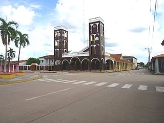
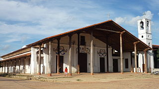
Entre Ríos is a town in the Bolivian Tarija Department.

<span class="mw-page-title-main">Salinas de Garci Mendoza</span> Place in Oruro Department, Bolivia

Salinas de Garci Mendoza is a town in the Bolivian Oruro Department. It is the administrative center of Ladislao Cabrera Province and is located 280 km (170 mi) south-west of Oruro, the capital of the department. It is situated at an elevation of 3,732 m (12,244 ft) at Caricha, 20 km north of the Tunupa stratovolcano. Salar de Coipasa,a salt lake, is 20 km north-west of Salinas de Garci Mendoza, and 15 km in south-eastern direction is Salar de Uyuni, the world's largest salt pan. Salinas de Garci Mendoza is the endpoint of the road from Chuquichamba via Andamarca and Aroma to Salinas de Garci Mendoza.

<span class="mw-page-title-main">San Lorenzo, Tarija</span>

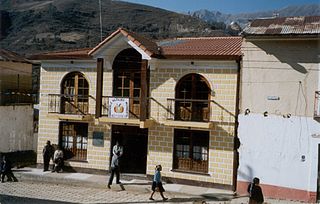
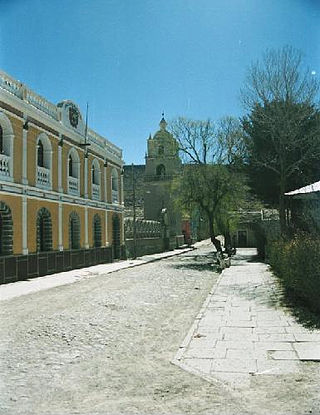
San Lorenzo is a town in the Tarija Department in Bolivia.

Uriondo is a town in the Bolivian Tarija Department.

<span class="mw-page-title-main">Turco Municipality</span> Municipality in Oruro Department, Bolivia

Turco Municipality is the second municipal section of the Sajama Province in the Oruro Department in Bolivia, and was founded on February 15, 1957. Its seat is Turco, situated 154 km west of Oruro at an altitude of 3,860 m. The municipality covers an area of 3,973 km², not taking into account the area of Laca Laca Canton.

<span class="mw-page-title-main">San Borja, Bolivia</span> City in Beni Department, Bolivia

San Borja is a city in the Beni Department in northern Bolivia, It is the most populous city in the province of General José Ballivián.

<span class="mw-page-title-main">Santa Ana del Yacuma</span> Town and municipality in Beni Department, Bolivia

Santa Ana del Yacuma is a town in the Beni Department in north-eastern Bolivia.

<span class="mw-page-title-main">San Ignacio de Moxos</span> Town and municipality in Beni Department, Bolivia

San Ignacio de Moxos is a town in the Beni Department of northern Bolivia.

<span class="mw-page-title-main">Monteagudo, Bolivia</span> Place in Chuquisaca, Bolivia

Monteagudo is a small town in South Eastern Bolivia. Its name is dedicated to Bernardo de Monteagudo Cáceres (1789-1825) who took part in the Chuquisaca revolution of 25 May 1809.

<span class="mw-page-title-main">San Joaquín, Bolivia</span> Town in Beni Department, Bolivia

San Joaquín is a small agricultural town in the Beni Department in the Bolivian lowlands.

San Ramón is a small town in the Beni Department in Bolivia.

<span class="mw-page-title-main">Vitichi</span> Town in Potosí Department, Bolivia

Vitichi is a location in the Potosí Department in Bolivia. It is the capital of the Vitichi Municipality, the second municipal section of the Nor Chichas Province.

<span class="mw-page-title-main">Azurduy Municipality</span> Municipality in Chuquisaca Department, Bolivia

Azurduy Municipality is the first municipal section of Azurduy Province in the Chuquisaca Department of Bolivia. Its seat is Villa Azurduy. In 2012 the population was 10,594 persons. The municipality is very poor; in 2010 93% were below the poverty line, and 75% were in extreme poverty. In 2001 there were seven automobiles in the municipality.

References

  1. "World Gazeteer".[ dead link ]
  2. "Base de datos Sistema Meteorológico–SISMET" (in Spanish). Servicio Nacional de Meteorología e Hidrología de Bolivia. Archived from the original on 7 June 2018. Retrieved 15 June 2024.
  3. "índices climáticos para 149 estaciones meteorológicas en Bolivia" (in Spanish). Servicio Nacional de Meteorología e Hidrología de Bolivia. Retrieved 15 June 2024.