Azurduy Municipality

Last updated
Azurduy Municipality
Municipality
Klimadiagramm Azurduy.png
Climate chart in the Walter and Lieth format, metric, °C und millimeters, made with Geoklima 2.1
Bolivia adm location map.svg
Red pog.svg
Azurduy Municipality
Location within Bolivia
Coordinates: 20°12′S64°26′W / 20.200°S 64.433°W / -20.200; -64.433
CountryBandera de Bolivia (Estado).svg  Bolivia
Department Chuquisaca Department
Province Azurduy Province
Seat Villa Azurduy
Government
  MayorRichard Cava Ferrufino
  PresidentFlorindo Zelaya Villalba
Elevation
[1]
8,200 ft (2,500 m)
Population
 (2012) [2]
  Total10,594
Time zone UTC-4 (BOT)

Azurduy Municipality (Municipio de Azurduy, [1] Villa Azurduy Municipality) is the first municipal section of Azurduy Province in the Chuquisaca Department of Bolivia. Its seat is Villa Azurduy. In 2012 the population was 10,594 persons. The municipality is very poor; in 2010 93% were below the poverty line, and 75% were in extreme poverty. [3] In 2001 there were seven automobiles (including trucks) in the municipality. [3]

Contents

Geography

The municipality is in the mountains of the Cordillera Oriental of the Andes, and is bordered on the west by the Pilcomayo River. The mountain ranges and the rivers are generally oriented north-south. Due to its elevation, the municipality experiences a wide range of temperatures between day and night. The average annual temperature is 14°C, the average monthly values varying between 10°C in June and July to 16°C in December and January. Annual precipitation barely reaches 550 millimetres (21.7 in), with less than 10 mm monthly in the dry season of May to August, and with the highest rainfall, 100 to 110 mm per month, between December and February.

To the north Azurduy Municipality is bordered by Tarvita Municipality, also of Azurduy Province, and El Villar Municipality of Tomina Province; to the east by Hernando Siles Province, and to the west and south by Nor Cinti Province. There are 132 settlements in the municipality [3] with thirty-six villages, of which only eight are accessible by road. [4]

Economics

The people are primarily employed in agriculture and livestock raising, although there is some mining. [3] Major crops include corn, wheat, potatoes, barley and peppers. Sheep, cattle, goats, pigs, horses and poultry are raised. [4]

The people

The people are predominantly indigenous citizens of Quechuan descent. [3]

Ethnic group %
Quechua 62.4
Aymara 0.1
Guaraní, Chiquitos, Moxos 0.1
Not indigenous or declined to state37.3
Other indigenous groups0.1

Population

The population of the municipality of Azurduy has not increased from 1992 to 2012. [5]

At the 2001 census, the literacy rate was 61.4 percent, the life expectancy of the newborn was 57.0 years, and the infant mortality rate was 9.3 per cent. 60.9 percent of the population spoke Spanish, 55.8 percent spoke Quechua (2001). 90.3 percent of the population had access to electricity, while 89.7 percent lived without sanitation facilities. [3] [5]

Cantons

The municipality is divided into three cantons. [3]

Related Research Articles

<span class="mw-page-title-main">Santo Domingo Province</span> Province of the Dominican Republic

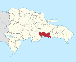
Santo Domingo is a province of the Dominican Republic. It was split from the Distrito Nacional on October 16, 2001.

<span class="mw-page-title-main">Caranavi Province</span> Province in La Paz Department, Bolivia

Caranavi Province is one of the twenty provinces of the Bolivian La Paz Department and is situated in the department's eastern parts. The province was created by Law 1401 on 16 December 1992 from a portion of what was then Nor Yungas Province. The creation of the province had been a local cause embraced by Ramiro Revuelta, a Deputy in the national legislature who was assassinated on November 28, 1992.

<span class="mw-page-title-main">Hernando Siles Province</span> Province in Chuquisaca, Bolivia

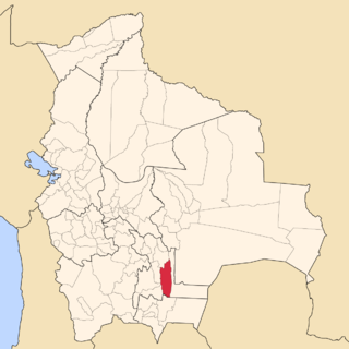
Hernando Siles is a province of the department of Chuquisaca, Bolivia. In the 2001 census it had a population of 36,511. It covers an area of 5,473 km², giving it a population density of 6.67/km². Its capital is Monteagudo.

<span class="mw-page-title-main">Azurduy Province</span> Province in Chuquisaca Department, Bolivia

Azurduy Province is a province in the Chuquisaca Department in Bolivia. Its seat is the town of Azurduy. It was named in honor of revolutionary guerrilla Juana Azurduy de Padilla. In the 2012 census it had a population of 24,855.

<span class="mw-page-title-main">Tomina</span> Place in Chuquisaca Department, Bolivia

Tomina is the seat of the homonymous municipality located in the Tomina Province in the Chuquisaca Department of Bolivia. At the time of the 2001 census it had 983 inhabitants.

Yamparáez is the seat of Yamparáez Municipality located in the Yamparáez Province in the Chuquisaca Department of Bolivia. At the time of census 2001 it had 903 inhabitants.

<span class="mw-page-title-main">Cantons of Costa Rica</span> Political subdivision of Costa Rica

Costa Rica is administratively divided into seven provinces which are subdivided into 84 cantons, and these are further subdivided into districts. Cantons are the only administrative division in Costa Rica that possess local government in the form of municipalities. Each municipality has its own mayor and several representatives, all of them chosen via municipal elections every four years.

<span class="mw-page-title-main">Federico Román Province</span>

Federico Román is one of the five provinces of the Bolivian department of Pando and is situated in the department's northeastern parts. Its name honours General Federico Román.

<span class="mw-page-title-main">Obispo Santistevan Province</span> Province of Bolivia

Obispo Santistevan is one of the fifteen provinces of the Bolivian Santa Cruz department and is situated in the department's western parts. The province was founded on 2 December 1941, and its name honors Obispo Santistevan (1843–1931), famous supporter of the building of Santa Cruz Cathedral.

<span class="mw-page-title-main">Ñuflo de Chávez Province</span> Province in Santa Cruz Department, Bolivia

Ñuflo de Chávez is one of the fifteen provinces of the Bolivian Santa Cruz Department and is situated in the northern and central parts of the department. The name of the province honors the conquistador Ñuflo de Chaves (1518–1556) who founded the city of Santa Cruz de la Sierra. Its capital is Concepción. The province was created by law of September 16, 1915, during the presidency of Ismael Montes. Originally it was part of the Chiquitos Province.

<span class="mw-page-title-main">Manuel María Caballero Province</span>

Manuel María Caballero Province is one of the fifteen provinces of the Bolivian Santa Cruz Department and is situated in the department's western parts. The province name honors deputy Manuel María Caballero from Vallegrande, one of the signatories of the Bolivian constitution of 5 August 1861.

<span class="mw-page-title-main">Parapetí River</span> River in Bolivia

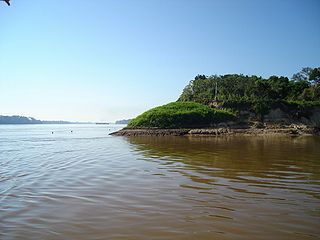
The Parapetí River is a river in Bolivia that has its source on the eastern side the Andes, flows through the Gran Chaco of Bolivia and ends in the marshes of the Bañados de Izozog depression. The drainage basin is 25,300 km2, and with the inclusion of the Bañados of Izozog is 61,903 km2.

Arbieto Municipality is the third municipal section of the Esteban Arce Province in the Cochabamba Department, Bolivia. Its seat is Arbieto. At the time of census 2001 the municipality had 9,438 inhabitants.

<span class="mw-page-title-main">Sacabamba Municipality</span> Municipality in Cochabamba Department, Bolivia

Sacabamba Municipality is the fourth municipal section of the Esteban Arce Province in the Cochabamba Department, Bolivia. Its seat is Sacabamba. At the time of census 2001 the municipality had 4,718 inhabitants.

San Benito Municipality or Villa José Quintín Mendoza Municipality is the third municipal section of the Punata Province in the Cochabamba Department, Bolivia. Its seat is San Benito. At the time of census 2001 the municipality had 12,720 inhabitants.

<span class="mw-page-title-main">Arani Municipality</span> Municipality in Cochabamba Department, Bolivia

Arani Municipality is the first municipal section of the Arani Province in the Cochabamba Department, Bolivia. Its seat is Arani. At the time of census 2001, the municipality had 11,542 inhabitants.

Sipe Sipe is a location in the Cochabamba Department in central Bolivia. It is the seat of the Sipe Sipe Municipality, the second municipal section of the Quillacollo Province.

Villa Serrano is a small town in the Chuquisaca Department, Bolivia. It is the seat of the Belisario Boeto Province. At the time of census 2001 it had 2,877 inhabitants.

San Pedro de Quemes is one of the cantons of the San Pedro de Quemes Municipality, the second municipal section of the Nor Lípez Province in the Potosí Department of Bolivia. During the census of 2001 it had 574 inhabitants. Its seat is San Pedro de Quemes with a population of 490 in 2001.

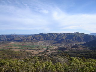
Villa Orias (Tarvita) is a town and administrative centre in Tarvita Municipality, Azurduy Province, Chuquisaca Department of Bolivia. It is in the Cordillera Oriental of the Andes, where the Puca Mayu River and the Cruz Mayu River meet to form the Tarvita River.

References

  1. 1 2 "Municipio de Azurduy" (in Spanish). Jefatura del Sector de Turismo del Gobierno Autónomo de Chuquisaca. Archived from the original on 3 January 2014. Retrieved 5 February 2014.
  2. INE – Instituto Nacional de Estadística Bolivia 2012 Archived 2016-03-04 at the Wayback Machine
  3. 1 2 3 4 5 6 7 "Atlas Municipal: Azurduy" (PDF). Instituto Nacional de Estadística de Bolivia. Archived (PDF) from the original on 5 February 2014.
  4. 1 2 "Consejo Municipal de Azurduy Elabora Cronograma para la Construcción de la Carta Orgánica Municipal (COM)" (in Spanish). Acción Cultural Loyola (ACLO). July 2012. Archived from the original on 5 February 2014.
  5. 1 2 "Chuquisaca: Proyecciones de Población por Provincias y Municipios, según Sexo, Edades Simples y Años Calendario, Período 2000 - 2010" (PDF) (in Spanish). La Paz, Bolivia: Instituto Nacional de Estadística de Bolivia. August 2005. Archived from the original (PDF) on 2016-03-04.

20°11′S64°27′W / 20.183°S 64.450°W / -20.183; -64.450