Monteagudo Municipality

Last updated
Panoramic view of Monteagudo Monteagudo.JPG
Panoramic view of Monteagudo

Municipality Municipality is the first municipal section of Hernando Siles Province in the Chuquisaca Department in Bolivia. Its seat is Monteagudo.

Municipalities of Bolivia administrative division of Bolivia

Municipalities in Bolivia are administrative divisions of the entire national territory governed by local elections. Municipalities are the third level of administrative divisions, below departments and provinces. Some of the provinces consist of only one municipality. In these cases the municipalities are identical to the provinces they belong to.

Hernando Siles is a province of the department of Chuquisaca, Bolivia. In the 2001 census it had a population of 36,511. It covers an area of 5,473 km², giving it a population density of 6.67/km². Its capital is Monteagudo.

Chuquisaca Department Place in Bolivia

Chuquisaca is a department of Bolivia located in the center south. It borders on the departments of Cochabamba, Tarija, Potosí, and Santa Cruz. The departmental capital is Sucre, which is also the constitutional capital of Bolivia.

Languages

The languages spoken in the Monteagudo Municipality are mainly Spanish, Quechua, Guaraní and Aymara.

Spanish language Romance language

Spanish or Castilian is a Romance language that originated in the Castile region of Spain and today has hundreds of millions of native speakers in the Americas and Spain. It is a global language and the world's second-most spoken native language, after Mandarin Chinese.

Aymara language native language in South America

Aymara is an Aymaran language spoken by the Aymara people of the Andes. It is one of only a handful of Native American languages with over one million speakers. Aymara, along with Spanish, is one of the official languages of Bolivia and parts of Peru. It is also spoken, to a much lesser extent, by some communities in northern Chile, where it is a recognized minority language.

LanguageInhabitants
Quechua 2,745
Aymara 128
Guaraní 758
Another native 5
Spanish 24,689
Foreign163
Only native314
Native and Spanish3,223
Only Spanish21,469

Related Research Articles

Herrljunga Municipality Municipality in Västra Götaland County, Sweden

Herrljunga Municipality is a municipality in Västra Götaland County in western Sweden. Its seat is located in the town of Herrljunga.

Amezketa Municipality in Basque Country, Spain

Amezketa is a town located in the province of Gipuzkoa, in the Basque Autonomous Community, in the North of Spain. It is located at the foot of Txindoki.

Moyuta Place in Jutiapa, Guatemala

Moyuta is a municipality in the Jutiapa department of Guatemala.

Jutphaas is a former village and municipality in the province of Utrecht in the Netherlands. The municipality merged with Vreeswijk in 1971, and is now the northern half of the town of Nieuwegein.

Adolfo Gonzáles Chaves Partido Department in Argentina

Adolfo Gonzales Chaves is a partido of Buenos Aires Province in Argentina, it is located at coordinates 38°02′S60°05′W.

Uzovské Pekľany municipality of Slovakia

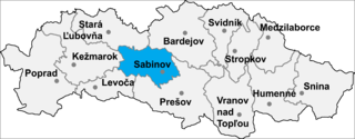
Uzovské Pekľany is a village and municipality in Sabinov District in the Prešov Regionof north-eastern Slovakia.

Pozán de Vero is a municipality located in the province of Huesca, Aragon, Spain. According to the 2004 census (INE), the municipality has a population of 244 inhabitants.

Santo Domingo de Pirón is a municipality located in the province of Segovia, Castile and León, Spain. According to the 2004 census (INE), the municipality has a population of 64 inhabitants.

Monteagudo de las Vicarías is a municipality located in the province of Soria, Castile and León, Spain. According to the 2004 census (INE), the municipality has a population of 268 inhabitants.

Lagoa Dourada human settlement in Brazil

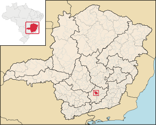
Lagoa Dourada is a Brazilian municipality located in the state of Minas Gerais. The city belongs to the mesoregion of Campo das Vertentes and to the microregion of Sao Joao del Rei.

Monteagudo, Navarre human settlement in Spain

Monteagudo is a town and municipality located in the province of Navarre, Spain. According to the 2006 census (INE), the municipality has a population of 1,146 inhabitants.

Joaíma human settlement in Brazil

Joaíma is a Brazilian municipality located in the northeast of the state of Minas Gerais.

Monteagudo, Bolivia Place in Chuquisaca, Bolivia

Monteagudo is a small town in South Eastern Bolivia. Its name is dedicated to Bernardo de Monteagudo Cáceres (1789-1825) who took part in the Chuquisaca revolution of 25 May 1809.

The Erskine Inlet is a natural waterway through the central Canadian Arctic Archipelago in Canada. It separates Cameron Island, Île Vanier, Massey Island and Alexander Island from Bathurst Island.

Chauveau Point headland

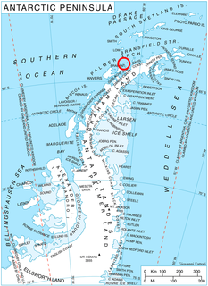
Chauveau Point is a headland on the north side of Zlogosh Passage marking the southwestern end of Liège Island, in the Palmer Archipelago.

Mount Pedersen is a mountain, 2,070 m, standing 9 nautical miles (17 km) southeast of Galatos Peak in Salamander Range, Freyberg Mountains. Mapped by United States Geological Survey (USGS) from surveys and U.S. Navy air photos, 1960–64. Named by Advisory Committee on Antarctic Names (US-ACAN) for John M. Pedersen, biologist at McMurdo Station, summers 1965–66 and 1966–67.

Falkenhof Glacier is a tributary glacier 7 nautical miles (13 km) long, flowing west from the vicinity of Tricorn Mountain to enter Snakeskin Glacier northwest of Mount Clarke, Antarctica. It was named by the Advisory Committee on Antarctic Names for Jack J. Falkenhof, a United States Antarctic Research Program meteorologist at South Pole Station, 1963.

Northwest (Icelandic constituency) Constituency of Iceland

Northwest Constituency is one of the six constituencies of Iceland. Its major town is Akranes.

References

Coordinates: 20°02′S64°05′W / 20.033°S 64.083°W / -20.033; -64.083

Geographic coordinate system Coordinate system

A geographic coordinate system is a coordinate system that enables every location on Earth to be specified by a set of numbers, letters or symbols. The coordinates are often chosen such that one of the numbers represents a vertical position and two or three of the numbers represent a horizontal position; alternatively, a geographic position may be expressed in a combined three-dimensional Cartesian vector. A common choice of coordinates is latitude, longitude and elevation. To specify a location on a plane requires a map projection.