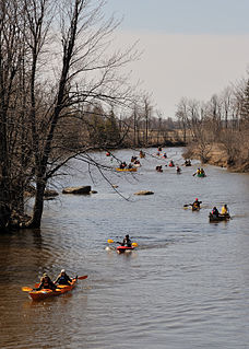
The Raisin River is a river in South Stormont and South Glengarry, United Counties of Stormont, Dundas and Glengarry in eastern Ontario, Canada, with the watershed encompassing portions of North Stormont, North Glengarry and the city of Cornwall as well. It empties into Lake Saint Francis on the Saint Lawrence River near the community of Lancaster.

The English River is a river in Kenora District and Thunder Bay District in Northwestern Ontario, Canada. It flows through Lac Seul to join the Winnipeg River at Tetu Lake as a right tributary. The river is in the Hudson Bay drainage basin, is 615 kilometres (382 mi) long and has a drainage basin of 52,300 square kilometres (20,200 sq mi). There are several hydroelectric plants on this river.

The Kenogami River is a river in the James Bay drainage basin in Thunder Bay and Cochrane districts in Northern Ontario, Canada, which flows north from Long Lake near Longlac to empty into the Albany River. The river is 320 kilometres (199 mi) in length and its name means "long water" in the Cree language. A portion of the river's headwaters have been diverted into the Lake Superior drainage basin.

The Wabigoon River is a river in Kenora District in northwestern Ontario, Canada. It flows from Raleigh Lake past Dryden, Ontario on Wabigoon Lake to join the English River. The name "Wabigoon" comes from the Ojibwe waabigon, "marigold", or waabi-miigwan, "white feather".

The Barron River is a river in the Saint Lawrence River drainage basin in Nipissing District and Renfrew County, Ontario, Canada. It flows from Clemow Lake in northern Algonquin Provincial Park and joins the Petawawa River, whose southern branch it forms, in the municipality of Laurentian Hills, near the municipality of Petawawa.
The Magpie River is a river in Algoma District, northeastern Ontario, Canada, The river empties into Michipicoten Bay on Lake Superior near the town of Wawa. The river drains an area of about 1,900 square kilometres (734 sq mi).

The Pukaskwa River is a river in Thunder Bay District and Algoma District in Northern Ontario, Canada. It is in the Great Lakes Basin and is a tributary of Lake Superior, which it enters at the south end of Pukaskwa National Park. It is a remote, pristine, free-flowing, medium-sized Shield river, with lots of whitewater, best travelled in spring.

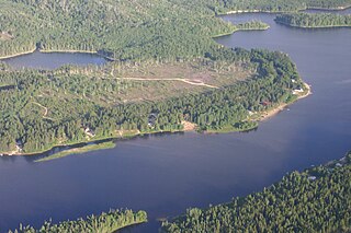
Ena Lake is the name of a lake and an adjacent unincorporated area and railway point in Unorganized Kenora District in northwestern Ontario, Canada, about 23 kilometres (14 mi) north of the city of Kenora. Formerly a stop on the Canadian National Railway, it is now a small cottage community of approximately 50 seasonal residents and 11 year round residents.
Canyon railway station is located in the community of Canyon in Unorganized Kenora District in northwestern Ontario, Canada. The railway station lies on the Canadian National Railway transcontinental main line, between Favel to the west and McIntosh to the east, and is in use by Via Rail as a stop for transcontinental Canadian trains.
McIntosh is an unincorporated place on Canyon Lake on the Canyon River in Unorganized Kenora District in northwestern Ontario, Canada. It lies on the Canadian National Railway transcontinental main line, between Canyon to the west and Quibell to the east, and is passed but not served by Via Rail transcontinental Canadian trains. The community can be accessed by road using the continuation of Ontario Highway 647 that arrives from the southeast from the community of Vermilion Bay, on Ontario Highway 17, via Blue Lake Provincial Park.
Quibell is an unincorporated place and railway point in Unorganized Kenora District in northwestern Ontario, Canada. It is named after William A. Quibell (1857-1917), a Police Commissioner in Durham County, Ontario. The Quibell Dam on the Wabigoon River lies 1.7 kilometres (1.1 mi) to the east.
The Vermilion River is a river in the Lake Huron drainage basin in Sudbury District and Greater Sudbury in Northeastern Ontario, Canada.
Favel is an unincorporated place on Favel Lake on the Canyon River in Unorganized Kenora District in northwestern Ontario, Canada.
Canyon is an unincorporated place on Canyon Lake on the Canyon River in Unorganized Kenora District in northwestern Ontario, Canada.

The Blanche River is a river in the Saint Lawrence River drainage basin in Timiskaming District in northeastern Ontario, Canada. The river is a tributary of Lake Timiskaming and its name is from the French for the colour "white".

The Kapuskasing River is a river in the James Bay drainage basin in Cochrane District and Algoma District in northeastern Ontario, Canada. The river is a left tributary of the Mattagami River.
The Ivanhoe River is a river in Cochrane District and Sudbury District in Northeastern Ontario, Canada. The river is in the James Bay drainage basin and is a left tributary of the Groundhog River.

The Groundhog River is a river in Cochrane District and Sudbury District in Northeastern Ontario, Canada. The river is in the James Bay drainage basin and is a left tributary of the Mattagami River.
The Matawin River is a river in Thunder Bay District in Northwestern Ontario, Canada. It is in the Great Lakes Basin and is a right tributary of the Kaministiquia River.
The Valentine River is a river in the Unorganized North Part of Cochrane District in northeastern Ontario, Canada. It is in the Moose River drainage basin, and is a tributary of Lac Pivabiska, the source of the Pivabiska River.
