Aeolus Valley is a village in the Yallahs district of the Jamaican parish of Saint Thomas. Although there has been a recent wave of violence and murders, residents still say that the community is a wonderful place.

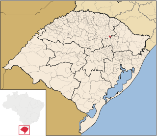
São Domingos do Sul is a municipality in the Brazilian state of Rio Grande do Sul. It is situated at a latitude of 28º31'51 South and a longitude of 51º53'16" West. As of 2020, it has an estimated population of 3,083 inhabitants on an area of 78.67 km². Its current mayor is Domingos Scartazzini.
Banksia Grove is a forest in the Rocky Cape National Park on the north west coast of Tasmania, Australia. The name refers to the plant genus Banksia, which grows in the area.
Iris Bay is a small bay immediately south of Muller Point at the east end of South Georgia, lying 6 miles (10 km) northwest of Cape Vahsel, along the embayment between Cape Vahsel and Cape Charlotte. The name "Sandwich Bay", for John Montagu, 4th Earl of Sandwich, was given to the whole embayment between Cape Vahsel and Cape Charlotte in 1775 by a British expedition under James Cook. The name was later restricted on maps to the small bay described, since a name for the large embayment was not considered useful. The South Georgia Survey, 1951–52, reported that the name Iris Bay for the same feature is well established in use among the whalers and sealers in South Georgia, and that the name Sandwich Bay is unknown locally, so Iris Bay was approved to conform with local usage.

Royal Bay is a bay, 6 km (3.7 mi) wide and indenting 8 km (5.0 mi), entered between Cape Charlotte and Cape Harcourt along the north coast of South Georgia.

Gold Harbour is a small bay 5 miles (8 km) south-southwest of Cape Charlotte, with Bertrab Glacier at its head, along the east end of South Georgia. During the early 1900s, the feature was variously called "Anna's Bay", "Gold-Hafen" or "Sandwich Bay"; the latter name has also been used for Iris Bay. The approved name appears to have taken root through common usage by sealers and whalers and is now well established.
Weddell Glacier is a glacier 2 nautical miles (3.7 km) long on the north side of South Georgia, flowing north into Royal Bay between Will Point and Cape Charlotte. First mapped by the German group of the International Polar Year Investigations, 1882–83, and named for James Weddell, Master, Royal Navy, who as a sealing captain visited South Georgia in 1823.

Torremayor is a municipality located in the province of Badajoz, Extremadura, Spain. According to the 2005 census (INE), the municipality has a population of 1020 inhabitants.

Cabañas de Yepes is a municipality located in the province of Toledo, Castile-La Mancha, Spain. According to the 2006 census (INE), the municipality has a population of 265 inhabitants.

Ciruelos de Cervera is a municipality located in the province of Burgos, Castile and León, Spain.
Salomon Glacier is a glacier flowing south into Hamilton Bay, at the east end of South Georgia. Named by the German Antarctic Expedition under Wilhelm Filchner, 1911–12.

The borders of the oceans are the limits of Earth's oceanic waters. The definition and number of oceans can vary depending on the adopted criteria. The principal divisions of the five oceans are the Pacific Ocean, Atlantic Ocean, Indian Ocean, Southern (Antarctic) Ocean, and Arctic Ocean. Smaller regions of the oceans are called seas, gulfs, bays, straits, and other terms. Geologically, an ocean is an area of oceanic crust covered by water.
The Northtrap Rocks are a small isolated group of rocks lying northwest of Cape Juncal, D'Urville Island, in the Joinville Island group. In association with Sauthtrap Rock, so named by United Kingdom Antarctic Place-Names Committee (UK-APC) in 1963 because the rocks are the northernmost of two features which should be avoided by vessels entering Antarctic Sound from the north.

Cape Whitson, is a headland on the south coast of Laurie Island, the easternmost and second largest of the South Orkney Islands of Antarctica. It lies about 9 km south-east of Argentina’s Orcadas Base.
Perkins Glacier is a broad, low gradient glacier 8 nautical miles (15 km) south-southeast of Cape Burks on the coast of Marie Byrd Land. It drains west from McDonald Heights into the east side of Hull Bay. Mapped by United States Geological Survey (USGS) from surveys and U.S. Navy air photos, 1959–65. Named by Advisory Committee on Antarctic Names (US-ACAN) for Earle B. Perkins, biologist with the Byrd Antarctic Expedition, 1933–35.

Cape Petersen is a rounded ice-covered cape on the north side of Thurston Island, about 18 nautical miles (33 km) east-northeast of Cape Flying Fish. It was delineated from air photos taken by U.S. Navy Operation HIGHJUMP in December 1946 and named by the Advisory Committee on Antarctic Names for Carl O. Petersen, radio engineer with the Byrd Antarctic Expedition in 1928-30 and 1933–35.
Cape Mikhaylov is an ice-covered point about 42 nautical miles (78 km) east of Totten Glacier, Wilkes Land, Antarctica. It was photographed by U.S. Navy Operation Highjump in 1947, and plotted on base compilation maps by Gardner Blodgett of the Office of Geography, U.S. Department of the Interior, in 1955. The cape was photographed by the Soviet Antarctic Expedition in 1956, and was named after Pavel N. Mikhaylov, artist with the Bellingshausen expedition of 1819–21.

Macaroni Point is a point marking the northeastern extremity of Deception Island, in the South Shetland Islands, Antarctica. The name arose following survey by the Falkland Islands Dependencies Survey in January 1954, because a colony of macaroni penguins is on this point.

Limit Rock is a rock awash, lying 2 nautical miles (4 km) east of North Foreland, the northeast cape of King George Island, in the South Shetland Islands on the Southern Ocean. It was charted in 1937 by Discovery Investigations personnel on the Discovery II, and so named because it marks the eastern limit of foul ground surrounding North Foreland.


