Cape Route

Last updated
Ptolemy's world map implied that Africa was part of an outer landmass, separating the Atlantic from the Indian Ocean. PtolemyWorldMap.jpg
Ptolemy's world map implied that Africa was part of an outer landmass, separating the Atlantic from the Indian Ocean.
The early Portuguese Empire centered around the Cape Route. Portuguese discoveries and explorationsV2en.png
The early Portuguese Empire centered around the Cape Route.
In 1500, Portuguese explorer Pedro Alvares Cabral used the prevailing winds on the Atlantic for a volta do mar, and thereby became the first European to arrive in Brazil. European sailors found the stop useful on the way to India. Cabral voyage 1500.svg
In 1500, Portuguese explorer Pedro Álvares Cabral used the prevailing winds on the Atlantic for a volta do mar, and thereby became the first European to arrive in Brazil. European sailors found the stop useful on the way to India.
Since the Suez Canal opened, the Cape Route has been used when passage through Suez is refused, or by Capesize ships. In the 1904-05 Russo-Japanese War, the Dogger Bank incident forced the Russian fleet to sail around Africa. Russian 2nd and 3rd Pacific Fleet voyage in 1905.svg
Since the Suez Canal opened, the Cape Route has been used when passage through Suez is refused, or by Capesize ships. In the 1904-05 Russo-Japanese War, the Dogger Bank incident forced the Russian fleet to sail around Africa.

The European-Asian sea route, commonly known as the sea route to India or the Cape Route, is a shipping route from the European coast of the Atlantic Ocean to Asia's coast of the Indian Ocean passing by the Cape of Good Hope and Cape Agulhas at the southern edge of Africa. The first recorded completion of the route was made in 1498 by Portuguese explorer Vasco da Gama, the admiral of the first Portuguese Armadas bound eastwards to make the discovery. The route was important during the Age of Sail, but became partly obsolete as the Suez Canal opened in 1869.

Contents

History

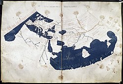
Scholars of classical antiquity disagreed whether the Atlantic was connected to the Indian Ocean. There are anecdotes about circumnavigation of Africa in ancient times; according to Herodotus, a Phoenician expedition commissioned by Egyptian king Necho II completed a voyage from the Red Sea to the Nile delta around 600 BC. Eudoxus of Cyzicus explored the West African coast, but was forced to return. Ptolemy's world map, on which the geographic knowledge of medieval Europe was founded, displays the oceans as separated from each other.

Discovery

In the late Middle Ages, the spice trade from India and the Silk Road from China were of economic importance, but the 1453 fall of Constantinople disrupted trade, and gave the Europeans incentives to find a sea route. Portuguese explorer Diogo Cão explored the African coast south to present-day Namibia, and Bartolomeu Dias found the Cape of Good Hope in 1488. Vasco da Gama headed an expedition which led to the Portuguese discovery of the sea route to India in 1498, and a series of expeditions known as the Carreira da Índia. Since then, the Cape Route has been in use.

Christopher Columbus sought to find a westward sea route to the Indian subcontinent, but instead found the way to the Americas. These expeditions marked the beginning of the Age of Discovery, in which European explorers charted the world's oceans.

Use during Age of Sail

The Cape Route was used by European East India Companies. In the 17th century, Caribbean pirates followed the Pirate Round; a parallel route from the Caribbean across the south Atlantic, to the Indian Ocean.

The European colonization of Africa was before the late 19th century mostly limited to a few coastal outposts, to support the Cape Route. The Dutch East India Company founded the Dutch Cape Colony as a layover port on the way to the Dutch East Indies.

The Brouwer Route was an extension of the Cape Route across the Indian Ocean to Indonesia. The Clipper Route is a route along the Roaring Forties between Europe and Australia.

Suez Canal

The Suez Canal opened in November 1869, allowing a shortcut between the Atlantic and the Indian Ocean. Because of the prevailing winds at Suez, the canal is less suitable for sailing boats, so steamships got a competitive advantage when the canal opened. While the Cape Route remained useful for clippers for some decades, the opening of the canal was the beginning of the end of the Cape Route, as well as the Age of Sail as a whole. Nowadays, the route around the Cape remains popular in yacht racing.

The maximum ship size for the Suez Canal are referred to as Suezmax. Capesize ships are those too large for the Suez Canal, which need to use the Cape Route between the Atlantic and the Indian Ocean. The 2015 inauguration of the New Suez Canal raised the Suezmax dimensions, and allowed larger ships. Thereby, the Cape Route became even less important, although it still is an alternative secondary route if the Suez Canal is somehow disrupted (for example, during the 2021 Suez Canal obstruction), or to avoid paying fees for crossing the canal if it is economically advantageous to do so. [1] [2] The journey can take up to two weeks longer for modern ships than a direct route via the Suez. [3]

See also

Related Research Articles

<span class="mw-page-title-main">Prince Henry the Navigator</span> Portuguese navigator and Prince (1394–1460)

Dom Henrique of Portugal, Duke of Viseu, better known as Prince Henry the Navigator, was a central figure in the early days of the Portuguese Empire and in the 15th-century European maritime discoveries and maritime expansion. Through his administrative direction, he is regarded as the main initiator of what would be known as the Age of Discovery. Henry was the fourth child of King Dom John I of Portugal, who founded the House of Aviz.

<span class="mw-page-title-main">Cape of Good Hope</span> Headland of Cape Peninsula, South Africa

The Cape of Good Hope is a rocky headland on the Atlantic coast of the Cape Peninsula in South Africa.

<span class="mw-page-title-main">History of Portugal (1415–1578)</span> Aspect of history

The history of the Kingdom of Portugal from the Illustrious Generation of the early 15th century to the fall of the House of Aviz in the late 16th century has been named the "Portuguese golden age" and the "Portuguese Renaissance". During this period, Portugal was the first European power to begin building a colonial empire as Portuguese sailors and explorers discovered an eastern route to India as well as several Atlantic archipelagos and colonized the African coast and Brazil. They also explored the Indian Ocean and established trading routes throughout most of southern Asia, sending the first direct European maritime trade and diplomatic missions to Ming China and to Japan, at the same time installing trading posts and the most important colony: Portuguese Macau. The Portuguese Renaissance produced a plethora of poets, historians, critics, theologians, and moralists. The Cancioneiro Geral by Garcia de Resende is taken to mark the transition from Old Portuguese to the modern Portuguese language.

<span class="mw-page-title-main">Vasco da Gama</span> Portuguese explorer of Africa and India

Vasco da Gama, 1st Count of Vidigueira, was a Portuguese explorer and the first European to reach India by sea.

<span class="mw-page-title-main">Bartolomeu Dias</span> Late 15th-century Portuguese maritime explorer

Bartolomeu Dias was a Portuguese mariner and explorer. In 1488, he became the first European navigator to round the southern tip of Africa and to demonstrate that the most effective southward route for ships lies in the open ocean, well to the west of the African coast. His discoveries effectively established the sea route between Europe and Asia.

<span class="mw-page-title-main">Geographical exploration</span> Act of traveling and searching for resources or for information about the land or space itself

Geographical exploration, sometimes considered the default meaning for the more general term exploration, refers to the practice of discovering remote lands and regions of the planet Earth. It is studied by geographers and historians.

<span class="mw-page-title-main">Pedro Álvares Cabral</span> Portuguese military commander and explorer (c. 1467/8 – c. 1520)

Pedro Álvares Cabral was a Portuguese nobleman, military commander, navigator and explorer regarded as the European discoverer of Brazil. He was the first human in history to ever be on four continents, uniting all of them in his famous voyage of 1500, where he also conducted the first substantial exploration of the northeast coast of South America and claimed it for Portugal. While details of Cabral's early life remain unclear, it is known that he came from a minor noble family and received a good education. He was appointed to head an expedition to India in 1500, following Vasco da Gama's newly opened route around Africa. The undertaking had the aim of returning with valuable spices and of establishing trade relations in India—bypassing the monopoly on the spice trade then in the hands of Arab, Turkish and Italian merchants. Although the previous expedition of Vasco da Gama to India, on its sea route, had recorded signs of land west of the southern Atlantic Ocean, Cabral led the first known expedition to have touched four continents: Europe, Africa, America, and Asia.

<span class="mw-page-title-main">Conquistador</span> Soldiers and explorers for the Spanish and Portuguese Empires

Conquistadors or conquistadores were the explorer-soldiers of the Spanish and Portuguese Empires of the 15th and 16th centuries. During the Age of Discovery, conquistadors sailed beyond Europe to the Americas, Oceania, Africa, and Asia, colonizing and opening trade routes. They brought much of the new world under the dominion of Spain and Portugal.

<span class="mw-page-title-main">Spice trade</span> Historic international commerce

The spice trade involved historical civilizations in Asia, Northeast Africa and Europe. Spices such as cinnamon, cassia, cardamom, ginger, pepper, nutmeg, star anise, clove, and turmeric were known and used in antiquity and traded in the Eastern World. These spices found their way into the Near East before the beginning of the Christian era, with fantastic tales hiding their true sources.

<span class="mw-page-title-main">Age of Discovery</span> Period of European global exploration from the 15th century to the 17th century

The Age of Discovery or the Age of Exploration, part of the early modern period and largely overlapping with the Age of Sail, was a period from approximately the 15th century to the 17th century, during which seafarers from a number of European countries explored, colonized, and conquered regions across the globe. The extensive overseas exploration, particularly the European colonization of the Americas, with the Spanish and Portuguese at the forefront, later joined by the Dutch, English, and French, marked an increased adoption of colonialism as a government policy in several European states. As such, it is sometimes synonymous with the first wave of European colonization.

<span class="mw-page-title-main">European exploration of Africa</span> Period of history

The geography of North Africa has been reasonably well known among Europeans since classical antiquity in Greco-Roman geography. Northwest Africa was known as either Libya or Africa, while Egypt was considered part of Asia.

<span class="mw-page-title-main">Ocean exploration</span> Part of oceanography describing the exploration of ocean surfaces

Ocean exploration is a part of oceanography describing the exploration of ocean surfaces. Notable explorations were undertaken by the Greeks, the Romans, the Polynesians, the Phoenicians, Phytheas, Herodotus, the Vikings, the Portuguese and Muslims. Scientific investigations began with early scientists such as James Cook, Charles Darwin, and Edmund Halley. Ocean exploration itself coincided with the developments in shipbuilding, diving, navigation, depth, measurement, exploration, and cartography.

<span class="mw-page-title-main">Padrão</span> Stone pillars erected by Portuguese mariners

A padrão is a stone pillar left by Portuguese maritime explorers in the 15th and 16th centuries to record significant landfalls and thereby establish primacy and possession. They were often placed on promontories and capes or at the mouths of major rivers. Early markers were simple wooden pillars or crosses but they deteriorated quickly in the tropical climate where they were often erected. Later, padrões were carved from stone in the form of a pillar surmounted by a cross and the royal coat of arms.

<span class="mw-page-title-main">Ottoman–Portuguese conflicts (1538–1560)</span> Series of military encounters between the Portuguese and Ottoman Empires

The Ottoman-Portuguese conflicts were a period of conflict during the Ottoman–Portuguese confrontations and series of armed military encounters between the Portuguese Empire and the Ottoman Empire along with regional allies in and along the Indian Ocean, Persian Gulf, and Red Sea.

<span class="mw-page-title-main">Portuguese maritime exploration</span> Numerous territories and maritime routes recorded by the Portuguese

Portuguese maritime exploration resulted in the numerous territories and maritime routes recorded by the Portuguese as a result of their intensive maritime journeys during the 15th and 16th centuries. Portuguese sailors were at the vanguard of European exploration, chronicling and mapping the coasts of Africa and Asia, then known as the East Indies, and Canada and Brazil, in what came to be known as the Age of Discovery.

The captain of a steam ship naturally chooses the shortest route to nearby destinations. Since a sailing ship is usually pushed by winds and currents, its captain must find a route where the wind will probably blow in the right direction. Tacking, i.e. using contrary wind to pull (sic) the sails, was always possible but wasted time because of the zigzagging required, and this would significantly delay long voyages. The early European explorers were not only looking for new lands. They also had to discover the pattern of winds and currents that would carry them where they wanted to go. During the age of sail winds and currents determined trade routes and therefore influenced European imperialism and modern political geography. For an outline to the main wind systems see Global wind patterns.

<i>São Gabriel</i> (ship)

São Gabriel was a Portuguese carrack and the flagship of Vasco da Gama's armada on his first voyage to India in 1497–1499.

<span class="mw-page-title-main">2nd Portuguese India Armada (Cabral, 1500)</span> Fleet of ships under Portuguese control, intended to open trade relations with India

The Second Portuguese India Armada was assembled in 1500 on the order of King Manuel I of Portugal and placed under the command of Pedro Álvares Cabral. Cabral's armada famously discovered Brazil for the Portuguese crown along the way. By and large, the Second Armada's diplomatic mission to India failed, and provoked the opening of hostilities between the Kingdom of Portugal and the feudal city-state of Calicut. Nonetheless, it managed to establish a factory in the nearby Kingdom of Cochin, the first Portuguese factory in Asia.

<span class="mw-page-title-main">Portuguese discovery of the sea route to India</span> First voyage to India from Europe (1495–99), by Vasco da Gama

The Portuguese discovery of the sea route to India was the first recorded trip directly from Europe to the Indian subcontinent, via the Cape of Good Hope. Under the command of Portuguese explorer Vasco da Gama, it was undertaken during the reign of King Manuel I in 1495–1499. Considered one of the most remarkable voyages of the Age of Discovery, it initiated the Portuguese maritime trade at Fort Cochin and other parts of the Indian Ocean, the military presence and settlements of the Portuguese in Goa and Bombay.

<span class="mw-page-title-main">Vasco da Gama Pillar, Malindi</span> School in Malindi, Kilifi County, Kenya

The Vasco da Gama Pillar in Malindi, Kenya, was erected by the Portuguese explorer Vasco da Gama. It was constructed in 1498 or 1499 during his pioneering maritime expedition from Lisbon to India via the Cape of Good Hope (1497–99).

References

  1. Hand, Marcus (6 May 2020). "Container lines divert 20 services via the Cape of Good Hope". Seatrade Maritime. Retrieved 27 March 2021.
  2. Braden, Dustin (29 February 2016). "Lines could save big by routing via Cape of Good Hope". www.joc.com. Journal of Commerce. Archived from the original on 23 April 2021. Retrieved 27 March 2021.
  3. "Suez Canal: Ships stuck in 'traffic jam' as salvage efforts continue". BBC News. 27 March 2021. Retrieved 28 March 2021.