Related Research Articles

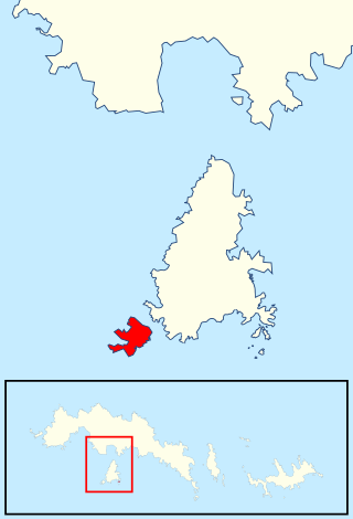
James Ross Island is a large island off the southeast side and near the northeastern extremity of the Antarctic Peninsula, from which it is separated by Prince Gustav Channel. Rising to 1,630 metres (5,350 ft), it is irregularly shaped and extends 64 km in a north–south direction. It was charted in October 1903 by the Swedish Antarctic Expedition under Otto Nordenskiöld, who named it for Sir James Clark Ross, the leader of a British expedition to this area in 1842 that discovered and roughly charted a number of points along the eastern side of the island. The style, "James" Ross Island is used to avoid confusion with the more widely known Ross Island in McMurdo Sound.
The Prince Gustav Channel was named in 1903 after Crown Prince Gustav of Sweden by Otto Nordenskiöld of the Swedish Antarctic Expedition.

Morton Strait is the 9 km (4.9 nmi)-long and 6.2 km (3.3 nmi)-wide strait between Snow Island on the southwest and Rugged Island and Livingston Island on the northeast, in the South Shetland Islands, Antarctica. The Aim Rocks and Long Rock lie in the strait.
Braces Point is the northeast point of Vindication Island, South Sandwich Islands. The feature was named Low Point during the survey from RRS Discovery II in 1930, but the name was changed to avoid duplication. The new name applied by the UK Antarctic Place-Names Committee in 1971 refers to the bifid form of this point, reaching out to the nearby sea stack of Trousers Rock.
Caroline Bluff is a bluff lying one nautical mile southeast of North Foreland, King George Island, in the South Shetland Islands. The bluff was charted and named "North Foreland Head" by Scottish geologist David Ferguson in 1921. To avoid confusion with North Foreland, the UK Antarctic Place-Names Committee rejected this name in 1960 and substituted a new one. The Hobart sealing vessel Caroline visited the South Shetland Islands in 1821–22.
Clapmatch Point is a low, lava point penetrated by narrow clefts, forming the southwest point of Candlemas Island, South Sandwich Islands. The name applied by the UK Antarctic Place-Names Committee in 1971 is a traditional sealers name for a female Fur seal. There is a breeding colony of this animal on the point.
Clinker Gulch is a gulch extending from Lucifer Hill to the north shore of Candlemas Island, South Sandwich Islands. The name applied by the UK Antarctic Place-Names Committee in 1971 reflects the actively volcanic, sulphurous nature of the area, and the loose piles of lava debris, resembling furnace clinkers, which wall the gulch.

Walker Point is a point on the southwest side of the entrance to Gurkovska Cove which lies 6 km (3.7 mi) south-west of Cape Valentine, near the eastern end of Elephant Island in the South Shetland Islands of Antarctica. The name appears on Powell's map of 1822 based upon the joint cruise of Captain Nathaniel B. Palmer, in the sloop James Monroe with Captain George Powell, in the sloop Dove, in December 1821. It was probably named for Captain John Walker, whose assistance in the construction of the map was acknowledged by Powell.
Tow Bay is a small bay 0.2 nautical miles (0.4 km) south of Vulcan Point on the west side of Candlemas Island, in the South Sandwich Islands. Charted and named in 1930 by DI personnel on the Discovery II.

Eillium Island is a small island 2.2 km (1.4 mi) north-west of Rumbo Punta, the north-west tip of Laurie Island in the South Orkney Islands of Antarctica. It was first seen and roughly charted by Captain George Powell and Captain Nathaniel Palmer during their joint cruise in 1821. It was recharted in 1903 by the Scottish National Antarctic Expedition under Dr. William S. Bruce, who named it for his son Eillium.
Moe Island is an island 2 km (1.2 mi) long in the South Orkney Islands off Antarctica, separated from the south-west end of Signy Island by Fyr Channel. It was charted by Captain Petter Sørlle in 1912–13, and named after M. Thoralf Moe of Sandefjord, Norway, a contemporary whaling captain who worked in this area. The northernmost point of the island is Spaull Point, named by United Kingdom Antarctic Place-Names Committee (UK-APC) after Vaughan W. Spaull, British Antarctic Survey (BAS) biologist on Signy Island, 1969.
Lucifer Hill is a reddish, cindery, sulphur-streaked hill forming the summit of the northern section of Candlemas Island in the South Sandwich Islands. It was one of the most active volcanic vents in this island chain at the time of HMS Protector's survey in 1964. The name applied by the UK Antarctic Place-Names Committee after Lucifer refers to the diabolical and infernal mythical association of active volcanoes. Clinker Gulch extends from Lucifer Hill to the northern shore of Candlemas.
Medusa Pool is a tidal lagoon which occupies the west side of the central lowlands of Candlemas Island in the South Sandwich Islands. The name, given by the UK Antarctic Place-Names Committee in 1971, is associated in classical mythology with the geomorphologically similar Gorgon Pool, nearby, Medusa being one of the gorgons.
Herrington Hill is a hill on the east side of Lavoisier Island, in the Biscoe Islands of Antarctica, about 5 nautical miles (9 km) southward of Benedict Point. It was mapped from air photos taken by the Falkland Islands and Dependencies Aerial Survey Expedition (1956–57), and was named by the UK Antarctic Place-Names Committee for Lovic P. Herrington, an American physiologist who has specialized in the reactions of the human body to cold environments.

The Lamborghini Aventador is a mid-engine sports car produced by the Italian automotive manufacturer Lamborghini. The Aventador’s namesake is a Spanish fighting bull that fought in Zaragoza, Aragón, in 1993. The Aventador is the successor to the Murciélago and was produced in Sant'Agata Bolognese, Italy.
Sea Serpent Cove is a small cove 1 nautical mile (1.9 km) southeast of Vulcan Point on the west side of Candlemas Island, in the South Sandwich Islands. Charted and named in 1930 by DI personnel on the Discovery II.

Hopkins Glacier is a glacier situated south of Erskine Glacier and flowing westwards into the head of Tlachene Cove in Darbel Bay on the west coast of Graham Land, Antarctica. It was photographed by Hunting Aerosurveys Ltd in 1955–57, and mapped from these photos by the Falkland Islands Dependencies Survey. It was named by the UK Antarctic Place-Names Committee in 1958 for Sir Frederick Hopkins, founder of the School of Biochemistry at Cambridge University, who made pioneer investigations on synthetic diets and vitamins which contributed greatly to the development of present ideas on concentrated rations.
References
 This article incorporates public domain material from "Carbon Point". Geographic Names Information System . United States Geological Survey.
Capital: King Edward Point | |||||||
| General | |||||||
| Settlements / Whaling stations | |||||||
| South Georgia islands | |||||||
| South Sandwich Islands |
| ||||||
| Seamounts | |||||||
| Landmarks |
| ||||||
| | This South Georgia and the South Sandwich Islands location article is a stub. You can help Wikipedia by expanding it. |