The photic zone, euphotic zone, epipelagic zone, or sunlight zone is the uppermost layer of a body of water that receives sunlight, allowing phytoplankton to perform photosynthesis. It undergoes a series of physical, chemical, and biological processes that supply nutrients into the upper water column. The photic zone is home to the majority of aquatic life due to the activity of the phytoplankton.

Oceanic anoxic events or anoxic events (anoxia conditions) describe periods wherein large expanses of Earth's oceans were depleted of dissolved oxygen (O2), creating toxic, euxinic (anoxic and sulfidic) waters. Although anoxic events have not happened for millions of years, the geologic record shows that they happened many times in the past. Anoxic events coincided with several mass extinctions and may have contributed to them. These mass extinctions include some that geobiologists use as time markers in biostratigraphic dating. On the other hand, there are widespread, various black-shale beds from the mid-Cretaceous which indicate anoxic events but are not associated with mass extinctions. Many geologists believe oceanic anoxic events are strongly linked to the slowing of ocean circulation, climatic warming, and elevated levels of greenhouse gases. Researchers have proposed enhanced volcanism (the release of CO2) as the "central external trigger for euxinia."
High-nutrient, low-chlorophyll (HNLC) regions are regions of the ocean where the abundance of phytoplankton is low and fairly constant despite the availability of macronutrients. Phytoplankton rely on a suite of nutrients for cellular function. Macronutrients are generally available in higher quantities in surface ocean waters, and are the typical components of common garden fertilizers. Micronutrients are generally available in lower quantities and include trace metals. Macronutrients are typically available in millimolar concentrations, while micronutrients are generally available in micro- to nanomolar concentrations. In general, nitrogen tends to be a limiting ocean nutrient, but in HNLC regions it is never significantly depleted. Instead, these regions tend to be limited by low concentrations of metabolizable iron. Iron is a critical phytoplankton micronutrient necessary for enzyme catalysis and electron transport.
Paleoceanography is the study of the history of the oceans in the geologic past with regard to circulation, chemistry, biology, geology and patterns of sedimentation and biological productivity. Paleoceanographic studies using environment models and different proxies enable the scientific community to assess the role of the oceanic processes in the global climate by the re-construction of past climate at various intervals. Paleoceanographic research is also intimately tied to paleoclimatology.

In oceanic biogeochemistry, the f-ratio is the fraction of total primary production fuelled by nitrate. The ratio was originally defined by Richard Eppley and Bruce Peterson in one of the first papers estimating global oceanic production. This fraction was originally believed significant because it appeared to directly relate to the sinking (export) flux of organic marine snow from the surface ocean by the biological pump. However, this interpretation relied on the assumption of a strong depth-partitioning of a parallel process, nitrification, that more recent measurements has questioned.
Anoxic waters are areas of sea water, fresh water, or groundwater that are depleted of dissolved oxygen. The US Geological Survey defines anoxic groundwater as those with dissolved oxygen concentration of less than 0.5 milligrams per litre. Anoxic waters can be contrasted with hypoxic waters, which are low in dissolved oxygen. This condition is generally found in areas that have restricted water exchange.
Dinocysts or dinoflagellate cysts are typically 15 to 100 µm in diameter and produced by around 15–20% of living dinoflagellates as a dormant, zygotic stage of their lifecycle, which can accumulate in the sediments as microfossils. Organic-walled dinocysts are often resistant and made out of dinosporin. There are also calcareous dinoflagellate cysts and siliceous dinoflagellate cysts.

The Azolla event is a scenario hypothesized to have occurred in the middle Eocene epoch, around 49 million years ago, when blooms of the freshwater fern Azolla are thought to have happened in the Arctic Ocean. As they sank to the stagnant sea floor, over a period of about 800,000 years, they were incorporated into the sediment; the resulting draw-down of carbon dioxide has been speculated to have helped transform the planet from a "greenhouse Earth" state, hot enough for turtles and palm trees to prosper at the poles, to the current icehouse Earth known as the Late Cenozoic Ice Age.
The Orca Basin is a mid-slope, silled, mini-basin in the northern Gulf of Mexico some 300 km southwest of the Mississippi River mouth on the Louisiana continental slope. It is unique amongst the mini-basins in this area, in containing a large brine pool of anoxic salt brine. The pool is approximately 123 km2 (47 sq mi) in area and up to 220 m (720 ft) deep under 2,400 m (7,900 ft) depth of Gulf water and is derived from dissolution of underlying Jurassic age Louann Salt. With a volume of 13.3 km3 (3.2 cu mi) the pool results from the dissolution of about 3.62 billion tonnes of the Louann Salt bed into seawater. The basin owes its shape to ongoing salt tectonics and is surrounded by salt diapirs.
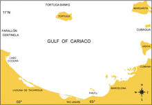
In 1995, the Ocean Time Series Program called CARIACO was initiated, completing 232 monthly core cruises through January 2017. This time series consists of field observations using ship, mooring, and satellite platforms in the eastern Cariaco Basin at 10°30’N, 64°40’W. The program seeks to understand the relationship between surface primary production, physical forcing variables like the wind, and the settling flux of particles in this unique location.
The Cenomanian-Turonian boundary event, also known as the Cenomanian-Turonian extinction, Cenomanian-Turonian oceanic anoxic event, and referred to also as the Bonarelli event, was one of two anoxic extinction events in the Cretaceous period. Selby et al. in 2009 concluded the OAE 2 occurred approximately 91.5 ± 8.6 Ma, though estimates published by Leckie et al. (2002) are given as 93–94 Ma. The Cenomanian-Turonian boundary has been refined in 2012 to 93.9 ± 0.15 Ma There was a large carbon disturbance during this time period. However, apart from the carbon cycle disturbance, there were also large disturbances in the oxygen and sulfur cycles of the ocean.

Dinosterol is a type of steroid produced by several genera of dinoflagellates. It is a 4α-methyl sterol (4α,23,24-trimethyl-5α-cholest-22E-en-3β-ol), a derivative of dinosterane, rarely found in other classes of protists.

Three Western Interior Seaway anoxic events occurred during the Cretaceous in the shallow inland seaway that divided North America in two island continents, Appalachia and Laramidia. During these anoxic events much of the water column was depleted in dissolved oxygen. While anoxic events impact the world's oceans, Western Interior Seaway anoxic events exhibit a unique paleoenvironment compared to other basins. The notable Cretaceous anoxic events in the Western Interior Seaway mark the boundaries at the Aptian-Albian, Cenomanian-Turonian, and Coniacian-Santonian stages, and are identified as Oceanic Anoxic Events I, II, and III respectively. The episodes of anoxia came about at times when very high sea levels coincided with the nearby Sevier orogeny that affected Laramidia to the west and Caribbean large igneous province to the south, which delivered nutrients and oxygen-adsorbing compounds into the water column.
Meltwater pulse 1B (MWP1b) is the name used by Quaternary geologists, paleoclimatologists, and oceanographers for a period of either rapid or just accelerated post-glacial sea level rise that some hypothesize to have occurred between 11,500 and 11,200 years ago at the beginning of the Holocene and after the end of the Younger Dryas. Meltwater pulse 1B is also known as catastrophic rise event 2 (CRE2) in the Caribbean Sea.
Euxinia or euxinic conditions occur when water is both anoxic and sulfidic. This means that there is no oxygen (O2) and a raised level of free hydrogen sulfide (H2S). Euxinic bodies of water are frequently strongly stratified, have an oxic, highly productive, thin surface layer, and have anoxic, sulfidic bottom water. The word euxinia is derived from the Greek name for the Black Sea (Εὔξεινος Πόντος (Euxeinos Pontos)) which translates to "hospitable sea". Euxinic deep water is a key component of the Canfield ocean, a model of oceans during the Proterozoic period (known as the Boring Billion) proposed by Donald Canfield, an American geologist, in 1998. There is still debate within the scientific community on both the duration and frequency of euxinic conditions in the ancient oceans. Euxinia is relatively rare in modern bodies of water, but does still happen in places like the Black Sea and certain fjords.

Axel Timmermann is a German climate physicist and oceanographer with an interest in climate dynamics, human migration, dynamical systems' analysis, ice-sheet modeling and sea level. He served a co-author of the IPCC Third Assessment Report and a lead author of IPCC Fifth Assessment Report. His research has been cited over 18,000 times and has an h-index of 70 and i10-index of 161. In 2017, he became a Distinguished Professor at Pusan National University and the founding Director of the Institute for Basic Science Center for Climate Physics. In December 2018, the Center began to utilize a 1.43-petaflop Cray XC50 supercomputer, named Aleph, for climate physics research.
An oxygen minimum zone (OMZ) is characterized as an oxygen-deficient layer in the world oceans. Typically found between 200m to 1500m deep below regions of high productivity, such as the western coasts of continents. OMZs can be seasonal following the spring-summer upwelling season. Upwelling of nutrient-rich water leads to high productivity and labile organic matter, that is respired by heterotrophs as it sinks down the water column. High respiration rates deplete the oxygen in the water column to concentrations of 2 mg/l or less forming the OMZ. OMZs are expanding, with increasing ocean deoxygenation. Under these oxygen-starved conditions, energy is diverted from higher trophic levels to microbial communities that have evolved to use other biogeochemical species instead of oxygen, these species include Nitrate, Nitrite, Sulphate etc. Several Bacteria and Archea have adapted to live in these environments by using these alternate chemical species and thrive. The most abundant phyla in OMZs are Pseudomonadota, Bacteroidota, Actinomycetota, and Planctomycetota.
Chlorobactane is the diagenetic product of an aromatic carotenoid produced uniquely by green-pigmented green sulfur bacteria (GSB) in the order Chlorobiales. Observed in organic matter as far back as the Paleoproterozoic, its identity as a diagnostic biomarker has been used to interpret ancient environments.

Lycopane (C40H82; 2,6,10,14,19,23,27,31-octamethyldotriacontane), a 40 carbon alkane isoprenoid, is a widely present biomarker that is often found in anoxic settings. It has been identified in anoxically deposited lacustrine sediments (such as the Messel formation and the Condor oil shale deposit). It has been found in sulfidic and anoxic hypersaline environments (such as the Sdom Formation). It has been widely identified in modern marine sediments, including the Peru upwelling zone, the Black Sea, and the Cariaco Trench. It has been found only rarely in crude oils.

The Southern Caribbean Upwelling system (SCUS) is a low latitude tropical upwelling system. Where; due to multiple environmental and bathymetric conditions water from the deep sea is forced to the surface layers of the ocean. The SCUS is located at about 10°N on the southern coast of the Caribbean sea basin off Colombia, Venezuela, and Trinidad.


