
The Division of Werriwa is an Australian electoral division in the state of New South Wales. The name Werriwa derives from a local Aboriginal name for Lake George, which was located in the division when it was established in 1900. The division was one of the original 65 divisions first contested at the first federal election.
Austral is a suburb of Sydney, in the state of New South Wales, Australia. It is 42 kilometres south-west of the Sydney central business district, in the local government area of the City of Liverpool.

West Hoxton is a suburb of Sydney, in the state of New South Wales, Australia. West Hoxton is located 40 kilometres west of the Sydney central business district, in the local government area of the City of Liverpool and is part of the Greater Western Sydney region.

Sadleir is a suburb in south-western Sydney, in the state of New South Wales, Australia. Sadleir is located 37 kilometres south-west of the Sydney central business district, in the local government area of the City of Liverpool.
Rossmore is a suburb of Sydney, in the state of New South Wales, Australia.

Prestons is a suburb of Sydney, in the state of New South Wales, Australia 37 kilometres south-west of the Sydney central business district, in the local government area of the City of Liverpool.
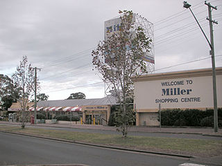
Miller is a suburb of Sydney in the state of New South Wales, Australia 38 kilometres south-west of the Sydney central business district, in the local government area of the City of Liverpool. Neighbouring suburbs include Hoxton Park, Hinchinbrook, Cartwright, Prestons, Sadleir and Busby.
Lurnea is a suburb of Sydney, in the state of New South Wales, Australia. It is 35 kilometres south-west of the Sydney central business district, in the local government area of the City of Liverpool.

The City of Liverpool is a local government area, administered by Liverpool City Council, located in the south-west of Sydney, in the state of New South Wales, Australia. The area encompasses 305.5 square kilometres (118.0 sq mi) and its administrative centre is located in the suburb of Liverpool.
Mount Pritchard is a suburb of Sydney, in the state of New South Wales, Australia 34 kilometres south-west of the Sydney central business district, in the local government areas of the City of Fairfield and the City of Liverpool, and is part of the South-western Sydney region.

Bonnyrigg is a suburb of Sydney, in the state of New South Wales, Australia 36 kilometres west of the Sydney central business district, in the local government area of the City of Fairfield. It is part of the Greater Western Sydney region.
Bringelly is a suburb of Sydney, in the state of New South Wales, Australia. It is located on the Northern Road between Penrith and Camden. It has a public school. Bringelly is also the name of a local hill.
Hoxton Park is a suburb of Sydney, in the state of New South Wales, Australia. Hoxton Park is located 38 kilometres west of the Sydney central business district, in the local government area of the City of Liverpool and is part of the Greater Western Sydney region.

Hinchinbrook is a suburb of Sydney, in the state of New South Wales, Australia. Hinchinbrook is located 35 kilometres south-west of the Sydney central business district, in the local government area of the City of Liverpool. It is bordered by Hoxton Park and Green Valley.

Horningsea Park is a suburb of Sydney, in the state of New South Wales, Australia. Horningsea Park is located 39 kilometres south-west of the Sydney central business district, in the local government area of the City of Liverpool and is part of the Greater Western Sydney region.

Liverpool is an electoral district of the Legislative Assembly of the Australian state of New South Wales in Sydney's West. It is currently represented by Charishma Kaliyanda of the Labor Party.
The Liverpool–Parramatta T-way is a continuous series of bus-only lanes and bus roadways between Parramatta and Liverpool in Western Sydney. Completed in February 2003, the 31 km (19.3 mi) T-way was the first bus rapid transit infrastructure to be built in Sydney.

Cabramatta Creek, an urban watercourse of the Georges River catchment, is located in the South Western Sydney, in New South Wales, Australia. The catchment area of the creek is approximately 74 square kilometres (29 sq mi), and within the catchment area are the Cabramatta Creek, Hinchinbrook Creek, Maxwells Creek, and Brickmakers Creek.

St Luke Parish is one of the 57 parishes of Cumberland County, New South Wales, a cadastral unit for use on land titles. It is bounded by Prospect Creek in the north-east, Georges River in the south-east, and Cowpasture Road in the west. It was named after the Anglican church of St Lukes in Liverpool, which was completed in 1819. The parish is mentioned in various legislation dealing with property law for the city of Liverpool.

