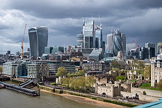
The City of London is a city, ceremonial county and local government district that contains the historic centre and the primary central business district (CBD) of London. It constituted most of London from its settlement by the Romans in the 1st century AD to the Middle Ages, but the modern city named London has since grown far beyond the City of London boundary. The City is now only a tiny part of the metropolis of London, though it remains a notable part of central London. Administratively, it forms one of the 33 local authority districts of London; however, the City of London is not a London borough, a status reserved for the other 32 districts. It is also a separate ceremonial county, being an enclave surrounded by Greater London, and is the smallest ceremonial county in the United Kingdom.

The City of Willoughby is a local government area on the Lower North Shore of Northern Sydney, in the state of New South Wales, Australia. It is located 6 kilometres (3.7 mi) north of the Sydney central business district. It was first proclaimed in October 1865 as the Municipality of North Willoughby.
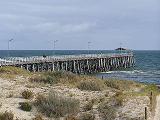
Grange is a coastal suburb of the City of Charles Sturt, in Adelaide, South Australia, located 11 kilometres from the Adelaide city centre. The suburb is named after Captain Charles Sturt's cottage, which still stands and is now a museum. In addition to Grange Beach, the suburb has several parks and reserves, as well as the Grange Hotel, which was originally licensed in 1881.

The Lane Cove Council is a local government area located on the Lower North Shore of Sydney, New South Wales, Australia. The administrative seat of Lane Cove is located 10 kilometres (6.2 mi) north-west of the Sydney central business district.

Fawdon is an electoral ward of Newcastle upon Tyne. It is also close to the A1 western bypass. The population of the ward is 10,890, reducing to 10,090 at the 2011 Census, 5.7% of the total population of Newcastle upon Tyne. Car ownership in the area is 53.6%, lower than the city average of 54.7%.

Byker is a district and electoral ward in the city of Newcastle upon Tyne, located in the east of the city. Byker is home to the Byker Wall estate, made famous by TV series Byker Grove. The population of the ward was recorded at 12,206 in the 2011 Census, which represented approximately 4.4% of the metropolitan borough of Newcastle upon Tyne. Byker is bordered by Heaton to the North and by Shieldfield to the North-East.

Dinnington is a village and civil parish in the city of Newcastle upon Tyne in Tyne and Wear, England. It is about 9 miles (14 km) north of the city centre, and about 5 miles (8.0 km) north-east of Newcastle International Airport. According to the 2011 Census, Dinnington Parish has 737 households and a population of 1,636; of whom 358 are 65 or over.

Woolsington is a village in and also a civil parish of the City of Newcastle upon Tyne, England. It is north-west of the city centre, and covers a large geographical area. It was also formerly an electoral wards, although the ward was slightly larger than the civil parish, extending slightly further south. The parish also includes Newbiggin Hall, Woolsington village and Newcastle Airport. It had a population of 11,160 as of the 2011 Census.

Blakelaw is an electoral ward situated in the West End of the city of Newcastle upon Tyne in North East England. The population of the ward is 11,186, which is 4.6% of the city's population. Car ownership in the area is 50.6%: this is lower than the city average of 54.7%, increasing to 11,507 at the 2011 Census. House prices in this area average at £114,000.
Dene is an electoral ward of Newcastle upon Tyne in North East England. The ward takes its name from the nearby gorge at Jesmond Dene. Contained within the ward are government offices of the Department for Work and Pensions and the Freeman Hospital. The population of the ward is 9,554, increasing to 9,667 at the 2011 Census, 3.7% of the total population of Newcastle upon Tyne. Car ownership in the area is 74.8% much higher than the city average of 54.7%.
Denton is an electoral ward of Newcastle upon Tyne in North East England. The ward encompasses the Chapel House and West Denton housing areas. The population the ward was 10,500 at the 2011 Census, 4.2% of the total population of Newcastle upon Tyne. Car ownership in the area is 56.6%, slightly higher than the city average of 54.7%.
Benwell and Scotswood is an electoral ward of Newcastle upon Tyne in North East England. The ward encompasses the Benwell and Scotswood housing areas, as well as the Newcastle Business Park, which is located on the banks of the River Tyne and houses offices of companies such as British Airways and the Automobile Association. The population of the ward is 13,759, which is 5.3% of the total population of Newcastle upon Tyne. Car ownership in the area is 45.1%, lower than the city average of 54.7%. The 2011 Census gave a population of 12,694.

The City of Newcastle is a local government area in the Hunter region of New South Wales, Australia. The City of Newcastle incorporates much of the area of the Newcastle metropolitan area.

Low Fell is a suburb of Gateshead situated in the Metropolitan Borough of Gateshead in Tyne and Wear, England. Built predominantly on sandstone, grindstone and clay, it is bordered by Sheriff Hill/Deckham to the east, Saltwell/Bensham to the west, Harlow Green to the south and Shipcote to the north. The suburb lies on a major bus route 2.5 miles south of Gateshead centre, 3 miles south of the city of Newcastle upon Tyne and 12 miles north of the historic City of Durham. The principal road in the suburb is the A167. According to the 2001 UK census, the suburb had a population of 8,643, falling marginally to 8,636 at the 2011 census.
East Gosforth also known as Gosforth East is an electoral ward in Newcastle upon Tyne, Tyne and Wear, UK. It was created in 2004. The population of the ward is 8,981, increasing to 10,145 at the 2011 Census, 3.5% of the total population of Newcastle upon Tyne. Car ownership in the area is 68.8%, higher than the city average of 54.7%. It is one half of Gosforth's wards, along with the West Gosforth ward.
West Gosforth was an electoral ward in the north of Newcastle upon Tyne, Tyne and Wear, England. It was created in 2004 and abolished in 2018. The population of the ward is 9,681, increasing to 9,991 at the 2011 Census, 3.7% of the total population of Newcastle upon Tyne. Car ownership in the area is 78.1%, higher than the city average of 54.7%.

Springwell Village is a village in the Borough of Gateshead, located approximately 4.5 miles (7.2 km) from Newcastle upon Tyne, 9 miles (14 km) from Sunderland, and 13 miles (21 km) from Durham. In 2011, Census data for the Gateshead Metropolitan Borough Council ward of Washington West recorded a total population of 11,833.
Wardley is a residential area in Gateshead, located around 4 miles (6.4 km) from Newcastle upon Tyne, 10 miles (16 km) from Sunderland, and 15 miles (24 km) from Durham. In 2011, Census data for the Gateshead Metropolitan Borough Council ward of Wardley and Leam Lane recorded a total population of 8,327.

Woolsington Hall is a Grade II* listed country house in a 92-acre (37 ha) estate, in the village of Woolsington, in the city of Newcastle, England, north-west of Newcastle city centre, and immediately south of Newcastle Airport. In addition to the hall, the stables, coach house, orangery, walled garden and east wing are Grade II listed.

Havannah Nature Reserve lies to the west of the village of Hazlerigg, approximately five miles north of the centre of Newcastle upon Tyne in the north of England. It was declared a nature reserve in 1998 and is designated a Site of Local Conservation Interest. A wildlife corridor runs through the site.

