Cazenovia, Illinois

Last updated
Cazenovia, Illinois
Unincorporated community
USA Illinois location map.svg
Red pog.svg
Cazenovia, Illinois
Usa edcp location map.svg
Red pog.svg
Cazenovia, Illinois
Coordinates: 40°51′01″N89°19′55″W / 40.85028°N 89.33194°W / 40.85028; -89.33194 Coordinates: 40°51′01″N89°19′55″W / 40.85028°N 89.33194°W / 40.85028; -89.33194
Country United States
State Illinois
County Woodford
Elevation 781 ft (238 m)
Time zone Central (CST) (UTC-6)
  Summer (DST) CDT (UTC-5)
Area code(s) 309
GNIS feature ID 405725 [1]

Cazenovia is an unincorporated community in Cazenovia Township, Woodford County, Illinois, United States. The community is located along Illinois Route 89 4.4 miles (7.1 km) north-northeast of Metamora. [2]

Cazenovia Township, Woodford County, Illinois Township in Illinois, United States

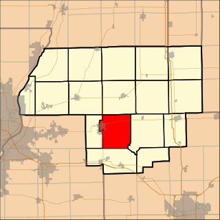
Cazenovia Township, Township 28 North, Range 2 West, is located in Woodford County, Illinois. It includes most of the town of Washburn, Illinois and the villages of Cazenovia and Low Point, Illinois and is traversed by State Route 89. As of the 2010 census, its population was 1,768 and it contained 721 housing units.

Woodford County, Illinois County in the United States

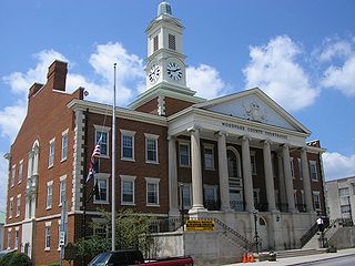
Woodford County is a county located in the state of Illinois. The 2010 United States Census listed its population at 38,664. Its county seat is Eureka.

Illinois State of the United States of America

Illinois is a state in the Midwestern region of the United States. It has the 5th largest Gross Domestic Product by state, is the 6th-most populous U.S. state and 25th-largest state in terms of land area. Illinois is often noted as a microcosm of the entire United States. With Chicago in the northeast, small industrial cities and great agricultural productivity in northern and central Illinois, and natural resources such as coal, timber, and petroleum in the south, Illinois has a diverse economic base, and is a major transportation hub. Chicagoland, Chicago's metropolitan area, contains over 65% of the state's population. The Port of Chicago connects the state to other global ports around the world from the Great Lakes, via the Saint Lawrence Seaway, to the Atlantic Ocean; as well as the Great Lakes to the Mississippi River, via the Illinois Waterway on the Illinois River. The Mississippi River, the Ohio River, and the Wabash River form parts of the boundaries of Illinois. For decades, Chicago's O'Hare International Airport has been ranked as one of the world's busiest airports. Illinois has long had a reputation as a bellwether both in social and cultural terms and, through the 1980s, in politics.

Related Research Articles

Woodford County, Kentucky County in the United States

Woodford County is a county located in the U.S. state of Kentucky. As of the 2010 census, the population was 24,939. Its county seat is Versailles.

McLean County, Illinois County in the United States

McLean County is the largest county by land area in the U.S. state of Illinois. According to the 2010 census, it had a population of 169,572. Its county seat is Bloomington.

Livingston County, Illinois County in the United States

Livingston County is a county located in the U.S. state of Illinois. According to the 2010 census, it has a population of 38,950. Its county seat is Pontiac.

Peoria Heights, Illinois Village in Illinois, United States

Peoria Heights is a village lying almost entirely in Peoria County in the U.S. state of Illinois. The population was 6,156 at the 2010 census, down from 6,635 in 2000. Peoria Heights is a suburb of Peoria and is surrounded by the city except for its eastern boundary on Peoria Lake, a relatively wider section of the Illinois River. It is part of the Peoria, Illinois Metropolitan Statistical Area.

Eureka, Illinois City in Illinois, United States

Eureka is a city in Olio Township, Woodford County, Illinois, United States. The population was 5,295 at the 2010 census. It is the county seat of Woodford County. Eureka is part of the Peoria, Illinois Metropolitan Statistical Area.

Cazenovia, New York Town in New York, United States

Cazenovia is a town in Madison County, New York, United States. The population was 7,086 at the 2010 census. The town is named after Theophilus Cazenove, an agent of the Holland Land Company.

Cazenovia College is a small, independent, co-educational, baccalaureate college, located in Cazenovia, New York, United States. Cazenovia offers a comprehensive liberal arts education with academic and co-curricular programs devoted to developing leaders in their professional fields.

New York State Route 92 highway in New York

New York State Route 92 (NY 92) is a state highway located in central New York in the United States. The western terminus of the route is at an intersection with U.S. Route 11 in downtown Syracuse. Its eastern terminus is at a junction with US 20 west of the village of Cazenovia. NY 92 is known as East Genesee Street through Syracuse and DeWitt; from DeWitt to Cazenovia, its name varies by location. It heads generally eastward through Syracuse to DeWitt, where it crosses Interstate 481 (I-481) while concurrent with NY 5. At the east end of the overlap, it splits off follows a more southeasterly routing through the village of Manlius to Cazenovia.

Illinoiss 11th congressional district

The 11th Congressional District of Illinois is represented by Democrat Bill Foster.

Olio Township, Woodford County, Illinois Township in Illinois, United States

Olio Township is located in Woodford County, Illinois. As of the 2010 census, its population was 4,931 and it contained 1,879 housing units.

Woodford State Fish and Wildlife Area protected area adjacent to and over the Illinois River

Woodford State Fish and Wildlife Area is an Illinois state park on 2,900 acres (1,200 ha) of area Woodford County, Illinois, United States. Most of this protected area is over the Goose Lake and Upper Peoria Lake sections of the Illinois River.

Cazenovia, Minnesota Unincorporated community in Minnesota, United States

Cazenovia is a former populated place in section 21 of Troy Township in Pipestone County, Minnesota, United States.

Peoria metropolitan area, Illinois geographic area around Peoria, Illinois

The Peoria Metropolitan Statistical Area, as defined by the United States Census Bureau, is an area consisting of five counties in Central Illinois, anchored by the city of Peoria. As of the 2010 census, the MSA had a population of 379,186. The City of Peoria, according to the estimated 2014 US Census Bureau, has 115,828 people.

Lowpoint, Illinois Unincorporated community in Illinois, United States

Lowpoint is an unincorporated community in Woodford County, Illinois, United States. Lowpoint is located along Illinois Route 89, south-southwest of Washburn. Lowpoint has a post office with ZIP code 61545.

Woodford, Illinois Unincorporated community in Illinois, United States

Woodford is an unincorporated community in Woodford County, Illinois, United States. Woodford is located along Illinois Route 251, 4 miles (6.4 km) south of Minonk.

National Register of Historic Places listings in Woodford County, Illinois Wikimedia list article

This is a list of the National Register of Historic Places listings in Woodford County, Illinois.

References