Spring Bay | |
|---|---|
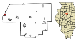 Location of Spring Bay in Woodford County, Illinois. | |
| Coordinates: 40°49′14″N89°31′43″W / 40.82056°N 89.52861°W [1] | |
| Country | United States |
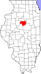
| State | Illinois |
| County | Woodford |
| Area | |
• Total | 0.91 sq mi (2.35 km2) |
| • Land | 0.68 sq mi (1.77 km2) |
| • Water | 0.22 sq mi (0.57 km2) |
| Elevation | 446 ft (136 m) |
| Population (2020) | |
• Total | 474 |
| • Density | 692.7/sq mi (267.44/km2) |
| Time zone | UTC-6 (CST) |
| • Summer (DST) | UTC-5 (CDT) |
| ZIP code | 61611 |
| Area code | 309 |
| FIPS code | 17-71604 |
| GNIS feature ID | 2399875 [1] |
| Website | https://www.villageofspringbay.org/ |
Spring Bay is a village in Woodford County, Illinois, United States. As of the 2010 United States census, the village population was 452, up from 436 in 2000. The village is part of the Peoria, Illinois Metropolitan Statistical Area.