
The Medicine Bow Mountains are a mountain range in the Rocky Mountains that extend 100 miles (160 km) from northern Colorado into southern Wyoming. The northern extent of this range is the sub-range the Snowy Range. From the northern end of Colorado's Never Summer Mountains, the Medicine Bow mountains extend north from Cameron Pass along the border between Larimer and Jackson counties in Colorado and northward into south central Wyoming. In Wyoming, the range sits west of Laramie, in Albany and Carbon counties to the route of the Union Pacific Railroad and U.S. Interstate 80. The mountains often serve as a symbol for the city of Laramie. The range is home to Snowy Range Ski Area.

Laurel Hill State Park is a 3,935-acre (1,592 ha) Pennsylvania state park in Jefferson and Middlecreek Townships, Somerset County, Pennsylvania in the United States. Laurel Hill Lake is a 63-acre (25 ha) man-made lake with a dam that was constructed during the Great Depression by the young men of CCC camps SP-8-PA and SP-15-PA. Laurel Hill State Park is 8 miles (13 km) from Interstate 76 just off Pennsylvania Route 31 near Bakersville and on Pennsylvania Route 653 near Trent.

Table Rock State Park is a 3,083-acre (12.48 km2) park at the edge of the Blue Ridge Mountains in northern Pickens County, South Carolina. The park includes Pinnacle Mountain, the tallest mountain totally within the state.

Backbone State Park is Iowa's oldest state park, dedicated in 1919. Located in the valley of the Maquoketa River, it is approximately three miles (5 km) south of Strawberry Point in Delaware County. It is named for a narrow and steep ridge of bedrock carved by a loop of the Maquoketa River originally known as the Devil's Backbone. The initial 1,200 acres (490 ha) were donated by E.M. Carr of Lamont, Iowa. Backbone Lake Dam, a relatively low dam built by the Civilian Conservation Corps (CCC) in the 1930s, created Backbone Lake. The CCC constructed a majority of trails and buildings which make up the park.
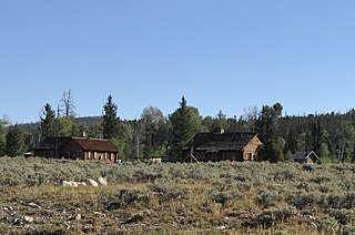
The Redick Lodge, also known as the Chambers Lodge, is a private seasonal retreat on Upper Fremont Lake near Pinedale, Wyoming in the Wind River Range at an elevation of 7,500 feet (2,300 m). The lodge was designed by architect Otis Miller of Miles City, Montana as a log cabin on a stone foundation for George M. Redick, a Nebraskan who had worked with the Union Pacific Railroad on potential locations for company hotels. The Redick family spent summers at the lodge from 1918 through 1931, when family fortunes declined. The property was purchased by Dr. Oliver Chambers of Rock Springs, Wyoming in 1938 and has remained in the Chambers family.
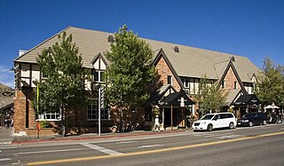
The Wort Hotel was built in downtown Jackson, Wyoming, United States by brothers John and Jess Wort, who were significant figures in the transformation of the economy of Jackson Hole from ranching to tourism. The somewhat Tudor-style building was the first luxury hotel in Jackson. The two-story building features brick facing, with half-timbering and stucco on the second floor and a series of gables facing the street.
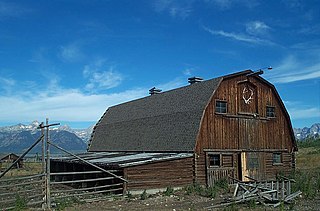
The Hunter Hereford Ranch was first homesteaded in 1909 by James Williams in the eastern portion of Jackson Hole, in what would become Grand Teton National Park. By the 1940s it was developed as a hobby ranch by William and Eileen Hunter and their foreman John Anderson. With its rustic log buildings it was used as the shooting location for the movie The Wild Country, while one structure with a stone fireplace was used in the 1963 movie Spencer's Mountain. The ranch is located on the extreme eastern edge of Jackson Hole under Shadow Mountain. It is unusual in having some areas of sagebrush-free pasture.

The Saddlehorn Caretaker's House and Garage, also known as the Stone House, the Rock House, and the Superintendent's Quarters is a house and asset listed as part of the National Register of Historic Places located in the Colorado National Monument.
Roaring River State Park is a public recreation area covering of 4,294 acres (1,738 ha) eight miles (13 km) south of Cassville in Barry County, Missouri. The state park offers trout fishing on the Roaring River, hiking on seven different trails, and the seasonally open Ozark Chinquapin Nature Center.

The Masonic Temple in downtown Casper, Wyoming is a Masonic hall, built in 1914 during a boom time initiated by the development of the Salt Creek Oil Field. Located on a corner site, the temple remains essentially as it was designed by Casper architect Homer F. Shaffer. The four story light-colored brick building rests on a raised basement and is topped by a crenelated parapet. The original windows have been replaced with vinyl units but retain the one-over-one appearance of the originals. Windows extend over the west and south sides. The north side is blank, while the east side is the building's rear facade and has fire escapes and a few windows.

Camp Douglas was an internment camp for Prisoners of War (POW) during World War II, located in the city of Douglas, Wyoming, United States. Between January 1943 and February 1946 in the camp housing first Italian and then German prisoners of war in the United States. While there are few remaining structures, the walls of the Officer's Club were painted with murals by three Italian prisoners. These paintings depicting western life and folklore are now registered with the United States Department of the Interior National Park Service on the National Register of Historic Places. The story of this POW camp is an important part of the history of the town of Douglas.
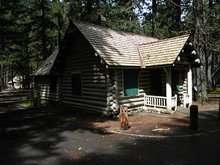
The Brush Creek Work Center in Medicine Bow National Forest near Saratoga, Wyoming is a ranger station of the USDA Forest Service, Region 2 that was built during 1937-41, by the Ryan Park CCC Camp, and is listed on the National Register of Historic Places. It was designed by architects of the United States Forest Service in rustic style. The designs were applications of standard plans.

Canelo Ranger Station, also known as Canelo Work Station, is a historic ranger station in the Coronado National Forest, within Santa Cruz County of southern Arizona. It is located in the ghost town of Canelo, within a small valley between the Canelo Hills on the west and the northern Huachuca Mountains on the east.

The Bergland Administrative Site, also known as the Bergland Ranger Station, is a government administrative complex consisting of six buildings located along M-28 in Bergland, Michigan. It was listed on the National Register of Historic Places in 2005, and currently houses the Bergland Cultural & Heritage Center and The Bergland/Matchwood Historical Society Museum.
Forest Lodge is a hunting and vacation retreat of the Livingston/Griggs family on the shore of Lake Namekagon within the town of Namakagon, Wisconsin. The complex consists of 16 rustic structures built from 1893 to about 1950. Since 1999 it has been managed by the Chequamegon-Nicolet National Forest. It was added to the National Register of Historic Places in 2002.

The Gasquet Ranger Station Historic District comprises a compound of buildings associated with the Gasquet Ranger District of Six Rivers National Forest. The U.S. Forest Service complex is located along the Smith River on U.S. Route 199 in Del Norte County, California, within Smith River National Recreation Area. Most of the buildings were built by the Civilian Conservation Corps between 1933 and 1939. Seven buildings and a rock wall remain of the CCC-built structures. The district office, the assistant district ranger's residence, a warehouse, two garages and a fuel house were built in the Forest Service rustic style that prevailed at the time. The style is reflected in distinctive detailing, including a recurring pine tree cut-out logo that appears on gables and shutters.

The Gold Creek Ranger Station is located in Humboldt-Toiyabe National Forest in Elko County, Nevada, USA. It was built in 1910 to administer the Ruby Mountains Forest Reserve, which became Humboldt National Forest. The compound was later expanded by labor provided by the Civilian Conservation Corps.
Architects of the National Park Service are the architects and landscape architects who were employed by the National Park Service (NPS) starting in 1918 to design buildings, structures, roads, trails and other features in the United States National Parks. Many of their works are listed on the National Register of Historic Places, and a number have also been designated as National Historic Landmarks.
The buildings of the Silver Creek Ranger Station typify Civilian Conservation Corps (CCC) and Economic Recovery Act (ERA). These relief programs employed local youth and experienced craftsmen. Building materials and camp supplies were obtained locally. The U.S. Forest Service's was the host agency and the facility was the headquarters for field operation The design of the buildings is an example of the rustic architectural style used by the Forest Service. Building 1362 is rare. Only three log Depression-era offices are known in the Pacific Northwest Region.

Ryan Park Camp is a historical site, 1 mile (1.6 km) east of the community of Ryan Park, Wyoming in Carbon County, Wyoming. The camp opened in 1930 as a Civilian Conservation Corps (CCC) camp during the Great Depression. Ryan Park Camp is at 8,009 feet (2,441 m) elevation in the Snowy Range of Wyoming's Rocky Mountains in the Medicine Bow National Forest on Wyoming Highway 130. Civilian Conservation Corps was supervised by the United States Forest Service. Civilian Conservation Corps camp closed in 1939. From 1942 to 1945 Ryan Park Camp operated as World War 2 Prisoner of war (POW) camp. Today there are no remains of the camp. The site is now a United States Forest Service public campground. A historical maker is at the entrance to the campground. Ryan Park Camp is named after Tom T. Ryan, who in 1879 founded a sawmill on the site on the western slopes of the Medicine Bow Mountains.


