The Snake River Ranch, near Wilson, Wyoming, is the largest deeded ranch in the Jackson Hole area. The ranch buildings are grouped into three complexes comprising headquarters, residential and shop complexes. The ranch combined two neighboring homesteads and was first owned by advertising executive Stanley B. Resor and his wife, Helen Lansdowne Resor. The Resors used the property as a vacation home, but the ranch was also a full-time, self-sustaining operation.

The Murie Ranch Historic District, also known as the STS Dude Ranch and Stella Woodbury Summer Home is an inholding in Grand Teton National Park near Moose, Wyoming. The district is chiefly significant for its association with the conservationists Olaus Murie, his wife Margaret (Mardy) Murie and scientist Adolph Murie and his wife Louise. Olaus and Adolph Murie were influential in the establishment of an ecological approach to wildlife management, while Mardy Murie was influential because of her huge conservation victories such as passing the Alaska National Interest Lands Conservation Act of 1980 and being awarded with the highest civilian honor, the Presidential Medal of Freedom, for her lifetime works in conservation. Olaus Murie was a prominent early field biologist in the U.S. Biological Survey and subsequent U.S. Fish and Wildlife Service before retiring and becoming the president of the Wilderness Society, He was a prominent advocate for the preservation of wild lands in America.

The Cunningham Cabin is a double-pen log cabin in Grand Teton National Park in the US state of Wyoming. It was built as a homestead in Jackson Hole and represents an adaptation of an Appalachian building form to the West. The cabin was built just south of Spread Creek by John Pierce Cunningham, who arrived in Jackson Hole in 1885 and subsisted as a trapper until he established the Bar Flying U Ranch in 1888. The Cunninghams left the valley for Idaho in 1928, when land was being acquired for the future Grand Teton National Park.

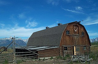
The 4 Lazy F Ranch, also known as the Sun Star Ranch, is a dude ranch and summer residence in Jackson Hole, Wyoming, built by the William Frew family of Pittsburgh in 1927. The existing property was built as a family retreat, not as a cattle ranch, in a rustic style of construction using logs and board-and-batten techniques. The historic district includes seven cabins, a lodge, barn corral and smaller buildings on the west bank of the Snake River north of Moose, Wyoming. The property was added to the National Register of Historic Places in 1990.
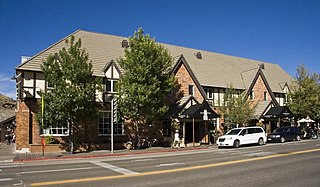
The Wort Hotel was built in downtown Jackson, Wyoming, United States by brothers John and Jess Wort, who were significant figures in the transformation of the economy of Jackson Hole from ranching to tourism. The somewhat Tudor-style building was the first luxury hotel in Jackson. The two-story building features brick facing, with half-timbering and stucco on the second floor and a series of gables facing the street.
The Hunter Hereford Ranch was first homesteaded in 1909 by James Williams in the eastern portion of Jackson Hole, in what would become Grand Teton National Park. By the 1940s it was developed as a hobby ranch by William and Eileen Hunter and their foreman John Anderson. With its rustic log buildings it was used as the shooting location for the movie The Wild Country, while one structure with a stone fireplace was used in the 1963 movie Spencer's Mountain. The ranch is located on the extreme eastern edge of Jackson Hole under Shadow Mountain. It is unusual in having some areas of sagebrush-free pasture.

The TA Ranch was the site of the principal events of the Johnson County Range War in 1892. The TA was established in 1882 as one of the first ranches in Johnson County, Wyoming. The TA is the only intact site associated with the range war, with trenches used by both sides still visible and scars on the nearby buildings. The ranch also documents the expansion and development of cattle ranching in Wyoming.
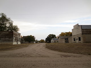
The Jay Em Historic District comprises the abandoned center of the village of Jay Em, Wyoming. The town was planned and established by Lake Harris between 1912 and 1915 as a service town supporting ranchers in the surrounding area. The place was recognized as a town in 1915 when a post office was established. Tours of the site are available by appointment.
The Sommers Ranch Headquarters Historic District is a historic ranch complex located southwest of Pinedale, Wyoming. The district includes 11 wooden buildings, including a homestead house, a bunkhouse, a barn, and various other farm buildings and outbuildings. Albert P. "Prof" Sommers founded the ranch in 1908. Sommers married May McAlister in 1911; after the couple bought land from May's parents and her friend Nellie Yates, their ranch grew to 1,900 acres (770 ha). The ranch is still operational and serves as an example of the many ranches built in the upper Green River Valley.

The James Cant Ranch is a pioneer ranch complex in Grant County in eastern Oregon, United States. The ranch is located on both sides of the John Day River in the John Day Fossil Beds National Monument. The ranch was originally homesteaded by Floyd Officer in 1890. Officer sold the property to James Cant in 1910. Cant increased the size of the property and built a modern ranch complex on the west bank of the river. The National Park Service bought the ranch from the Cant family in 1975, and incorporated the property into the John Day Fossil Beds National Monument. The National Park Service used the main house as a visitor center until 2003. Today, the Cant Ranch complex is preserved as an interpretive site showing visitors an early 20th-century livestock ranch. The James Cant Ranch is listed on the National Register of Historic Places.

The historical buildings and structures of Grand Teton National Park include a variety of buildings and built remains that pre-date the establishment of Grand Teton National Park, together with facilities built by the National Park Service to serve park visitors. Many of these places and structures have been placed on the National Register of Historic Places. The pre-Park Service structures include homestead cabins from the earliest settlement of Jackson Hole, working ranches that once covered the valley floor, and dude ranches or guest ranches that catered to the tourist trade that grew up in the 1920s and 1930s, before the park was expanded to encompass nearly all of Jackson Hole. Many of these were incorporated into the park to serve as Park Service personnel housing, or were razed to restore the landscape to a natural appearance. Others continued to function as inholdings under a life estate in which their former owners could continue to use and occupy the property until their death. Other buildings, built in the mountains after the initial establishment of the park in 1929, or in the valley after the park was expanded in 1950, were built by the Park Service to serve park visitors, frequently employing the National Park Service Rustic style of design.

The Centennial Work Center in Medicine Bow National Forest near Centennial, Wyoming was built in 1938. It was built to replace the nearby Centennial Ranger Station. It was designed by USDA Forest Service, Region 2 in USFS rustic architecture and served as a government office. It was listed on the National Register of Historic Places for its architecture. The listing included three contributing buildings, a bunkhouse, a combined office and bunkhouse, and a garage, on 5 acres (2.0 ha).
The Trujillo Homesteads are a historic ranch site near Mosca, Alamosa County, Colorado, not far from the Great Sand Dunes National Park. The area was first settled in the 1860s by Teofilo Trujillo, a Mexican sheep farmer. His son Pedro built a log cabin house beginning in 1879, along with other ranch outbuildings and structures. In 1902 the elder Trujillo's home was destroyed by fire during conflicts between English-speaking cattle ranchers and the Spanish Trujillos, who were by then major landowners in the area. The Trujillos sold their holdings, which became part the Medeno Zapata Ranch, now owned by The Nature Conservancy. The homestead area, including the surviving homestead and the ruins of the destroyed one, was declared a National Historic Landmark District in February 2012.

The Oxford Horse Barn, built in 1887, is located near Laramie, Wyoming in Albany County, Wyoming. It is one of the oldest and largest existing barns in Albany County. The barn in an excellent example of vernacular architecture as influenced by the English cattle and horse ranchers which immigrated to the American West. It is listed on the National Register of Historic Places.

The N.K. Boswell Ranch is one of the oldest ranches on the edge of the Laramie Plains along the Big Laramie River in Albany County, Wyoming, USA. The ranch was established in the early 1870s, possibly by a man named C.T. Waldron. The ranch is significant for its association with Nathaniel K. Boswell, who was Albany County Sheriff at a time when the county extended from Colorado to Montana.
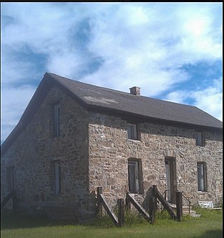
The Bath Ranch, also known as the Bath Brothers Ranch and the Stone Ranch, was established near Laramie, Wyoming by Henry Bath about 1869-70. It was one of the first ranches in Albany County. The initial homestead was replaced by the present stone house and barn in 1875, using stone quarried locally by Henry and his sons. Since the area was populated by hostile Native Americans, the buildings were designed as fortified refuges. The Bath family became prominent in Wyoming society in subsequent years.
The Divide Sheep Camp, also known as Niland's Cabins, is a ranch site on the Little Snake River in Carbon County, Wyoming, near Baggs. The camp was established in 1909 for summer use by sheepmen of the Niland-Tierney Sheep Company and others in the Little Snake valley. Eventually becoming the Divide Sheep Company the company operated until 1974, leaving the structures intact. The principal elements are a one-story log cabin with a finished attic, measuring about 25 feet (7.6 m) by 40 feet (12 m) built in the early 1920s, a log bunkhouse dating to about 1914, a spring house and a generator shed. The site represents a moderately-well-preserved turn-of-the-century sheep camp.
The Diamond A Ranch, or Spring Ranch, is a ranch in the upper Wind River valley of Fremont County, Wyoming. The site was first settled by John Robert McDonald, a Scottish immigrant who had a 160-acre (65 ha) homestead on the site in 1891. McDonald sold the property to John Williamson in 1907. Jack Williamson and his brother David were Scots as well, working as stonemasons. The Williamsons had worked in New York City, at Princeton University, at the Mormon Temple in Salt Lake City and on bridge work for the Union Pacific Railroad. In 1888 they came from Salt Lake City to Lander, where they worked on a number of projects, as well as in Rawlins and at Fort Washakie. They joined their sister Jean Williamson Sinclair at the Upper Circle Ranch near Dubois in the early 1890s. David Williamson married Annie McKenzie, a friend of his sister's who had come with her from Scotland. When Jack died of tick fever in 1916, David moved to the ranch with his family. After David's death in 1934, his wife Annie operated the ranch until she sold it in 1966. The ranch is notable as one of several ranches established by Scottish immigrants.
The Torrey Lake Club or Torrey Lake Ranch, also known as the Boardman Ranch or Murdock Ranch was built as a resort in the 1920s about 8 miles (13 km) southeast of Dubois, Wyoming. at an elevation of about 7,400 feet (2,300 m).The club is on about 603 acres (244 ha), centered on a complex of nine cabins, a bunkhouse for ranch hands and staff, and supporting structures. The log cabins were built by club members from local materials.

The Colter Ranch Historic District consists of twelve buildings in a rural setting near Eagar, Arizona. The site is located in the Amity Valley, which itself is part of Round Valley ; the Little Colorado River runs along the one side of the district. Most of the buildings date from between 1904 and 1930, the period during which Fred Colter resided on the residence.
