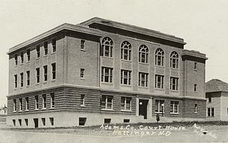
Adams County is a county in the U.S. state of North Dakota. As of the 2020 census, the population was 2,200. The county seat is Hettinger. The county was created on April 17, 1907, and organized one week later. It was named for John Quincy Adams (1848–1919), a railroad official for the Milwaukee Road Railroad and distant relative of sixth U.S. President John Quincy Adams (1767–1848).

Todd County is a county in the U.S. state of South Dakota. As of the 2020 United States Census, the population was 9,319. Todd County does not have its own county seat. Instead, Winner in neighboring Tripp County serves as its administrative center. Its largest city is Mission. The county was created in 1909, although it remains unorganized. The county was named for John Blair Smith Todd, a delegate from Dakota Territory to the United States House of Representatives and a Civil War general.

Oglala Lakota County is a county in southwestern South Dakota, United States. As of the 2020 census, the population was 13,672. Oglala Lakota County does not have a functioning county seat; Hot Springs in neighboring Fall River County serves as its administrative center. The county was created as a part of the Dakota Territory in 1875, although it remains unorganized. Its largest community is Pine Ridge.

Lawrence County is a county in the U.S. state of South Dakota. As of the 2020 census, the population was 25,768. Its county seat is Deadwood.

Williams County is located on the western border of the U.S. state of North Dakota, next to Montana. As of the 2020 census, the population was 40,950. making it the fifth-most populous county in North Dakota. Its county seat is Williston.

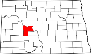
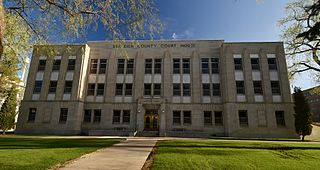
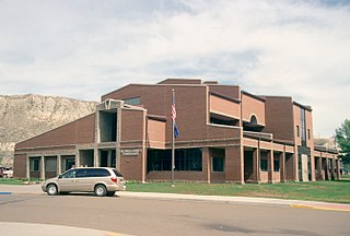
Stark County is a county in the U.S. state of North Dakota. As of the 2020 census, the population was 33,646. Its county seat is Dickinson.

Sioux County is a county located along the southern border of the U.S. state of North Dakota. As of the 2020 census, the population was 3,898. Its eastern border is the Missouri River and its county seat is Fort Yates.
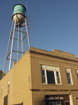
Nelson County is a county in the U.S. state of North Dakota. As of the 2020 census, the population was 3,015. Its county seat is Lakota.
Mercer County is a county in the U.S. state of North Dakota. As of the 2020 census, the population was 8,350. Its county seat is Stanton.

McKenzie County is a county in the U.S. state of North Dakota. As of the 2020 census, the population was 14,704. Its county seat is Watford City.

McIntosh County is a county in the U.S. state of North Dakota. As of the 2020 census, the population was 2,530. Its county seat is Ashley. The county is notable for being the county with the highest percentage of German-Americans in the United States, with over 76% of the county's residents being of German descent as of 2010.

Dickey County is a county in the U.S. state of North Dakota. As of the 2020 census, the population was 4,999. Its county seat is Ellendale.
Burleigh County is a county in the U.S. state of North Dakota. As of the 2020 census, the population was 98,458, making it the second-most populous county in North Dakota. Its county seat is Bismarck, the state capital. The county was named for Dakota Territory political figure Walter A. Burleigh.
Billings County is a county in the U.S. state of North Dakota. As of the 2020 census, the population was 945, making it the second-least populous county in North Dakota. Its county seat and only incorporated place is Medora.
Angora Township is a township in Saint Louis County, Minnesota, United States. The population was 249 at the 2010 census. Angora Township was named after Angora, in Turkey.
Ellsburg Township is a township in Saint Louis County, Minnesota, United States. The population was 219 at the 2010 census.

Oglala is a census-designated place (CDP) in West Oglala Lakota Unorganized Territory equivalent, Oglala Lakota County, South Dakota, United States. The population was 1,282 at the 2020 census. Its location is in the northwest of the Pine Ridge Indian Reservation.

Central Aroostook is an unorganized territory in Aroostook County, Maine, United States. The population was 164 at the 2020 census.
Dixon Township was a township in Logan County, North Dakota, United States. The former township government was disbanded in 2001, and the area was designated by the United States Census Bureau as Dixon Unorganized Territory. It later was merged into the West Logan Unorganized Territory.
Bryant Township was a township in Logan County, North Dakota, United States. The former township was merged into the West Logan Unorganized Territory.

