Four Bears Village, North Dakota

Last updated

Four Bears Village, North Dakota
CDP
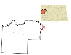
ND McKenzie County Four Bears Village.svg
Coordinates: 47°59′14″N102°35′37″W / 47.98722°N 102.59361°W / 47.98722; -102.59361
Country United States
State North Dakota
County McKenzie
Area
[1]
  Total1.02 sq mi (2.65 km2)
  Land1.02 sq mi (2.65 km2)
  Water0.00 sq mi (0.00 km2)
Elevation
[2]
1,946 ft (593 m)
Population
 (2020)
  Total500
  Density489.72/sq mi (189.03/km2)
Time zone UTC-6 (Central (CST))
  Summer (DST) UTC-5 (CDT)
Area code 701
FIPS code 38-27950 [3]
GNIS feature ID2393008 [2]

Four Bears Village is a census-designated place (CDP) in McKenzie County, North Dakota, United States. The population was 500 at the 2020 census.

Contents

Geography

According to the United States Census Bureau, the CDP has a total area of 1.0 square mile (2.6 km2), all land.

Demographics

Historical population
CensusPop.Note
1990 309
2000 36417.8%
2010 51742.0%
2020 500−3.3%
U.S. Decennial Census

As of the census [3] of 2000, there were 364 people, 87 households, and 80 families residing in the CDP. The population density was 348.8 inhabitants per square mile (134.7/km2). There were 90 housing units at an average density of 86.2 per square mile (33.3/km2). The racial makeup of the CDP was 4.12% White, 93.96% Native American, and 1.92% from two or more races. Hispanic or Latino of any race were 3.02% of the population.

There were 87 households, out of which 65.5% had children under the age of 18 living with them, 42.5% were married couples living together, 36.8% had a female householder with no husband present, and 8.0% were non-families. 6.9% of all households were made up of individuals, and 1.1% had someone living alone who was 65 years of age or older. The average household size was 4.18 and the average family size was 4.19.

In the CDP, the population was spread out, with 48.6% under the age of 18, 7.7% from 18 to 24, 29.1% from 25 to 44, 11.5% from 45 to 64, and 3.0% who were 65 years of age or older. The median age was 19 years. For every 100 females, there were 83.8 males. For every 100 females age 18 and over, there were 76.4 males.

The median income for a household in the CDP was $28,194, and the median income for a family was $26,250. Males had a median income of $29,125 versus $17,500 for females. The per capita income for the CDP was $7,681. About 35.7% of families and 31.2% of the population were below the poverty line, including 38.0% of those under age 18 and 50.0% of those age 65 or over.

Education

It is within New Town Public Schools. [4]

Related Research Articles

<span class="mw-page-title-main">Mandaree, North Dakota</span> Census-designated place & Unincorporated community in North Dakota, United States

Mandaree is a census-designated place (CDP) in McKenzie County, North Dakota, United States. The population was 596 at the 2010 census.

<span class="mw-page-title-main">East Dunseith, North Dakota</span> CDP in North Dakota, United States

East Dunseith is a census-designated place (CDP) in Rolette County, North Dakota, United States. The population was 500 at the 2020 census.

<span class="mw-page-title-main">Cannon Ball, North Dakota</span> CDP in Standing Rock Indian Reservation, United States

Cannon Ball is a census-designated place (CDP) on the Standing Rock Indian Reservation and in Sioux County, North Dakota, United States. It is located in the northeastern part of Sioux County, having developed at the confluence of the Cannonball River and Lake Oahe of the Missouri River. The population was 875 at the 2010 census.

<span class="mw-page-title-main">Storla, South Dakota</span> CDP in South Dakota, United States

Storla is a census-designated place (CDP) in Aurora County, South Dakota, United States. The population was 6 in the 2020 census.

<span class="mw-page-title-main">Fort Thompson, South Dakota</span> CDP in South Dakota, United States

Fort Thompson is a census-designated place (CDP) in Buffalo County, South Dakota, United States. The population was 1,282 at the 2010 census, making it the largest settlement on the Crow Creek Reservation.

<span class="mw-page-title-main">Bullhead, South Dakota</span> CDP in South Dakota, United States

Bullhead is a census-designated place (CDP) in Corson County, South Dakota, United States, within the Standing Rock Indian Reservation. The population was 348 at the 2010 census.

<span class="mw-page-title-main">Loomis, South Dakota</span> CDP in South Dakota, United States

Loomis is a census-designated place (CDP) in Davison County, South Dakota, United States. The population was 33 at the 2020 census. It is part of the Mitchell, South Dakota Micropolitan Statistical Area.

<span class="mw-page-title-main">North Eagle Butte, South Dakota</span> Census-designated place in South Dakota, United States

North Eagle Butte is a census-designated place (CDP) in Dewey County, South Dakota, United States, along the 45th parallel. The population was 1,879 at the 2020 census.

<span class="mw-page-title-main">St. Charles, South Dakota</span> CDP in South Dakota, United States

St. Charles or Saint Charles is a census-designated place (CDP) in Gregory County, South Dakota, United States. The population was 15 at the 2020 census.

<span class="mw-page-title-main">Kaylor, South Dakota</span> CDP in South Dakota, United States

Kaylor is a census-designated place (CDP) in Hutchinson County, South Dakota, United States. The population was 30 at the 2020 census.

<span class="mw-page-title-main">North Spearfish, South Dakota</span> Census-designated place in South Dakota, United States

North Spearfish is a census-designated place (CDP) in Lawrence County, South Dakota, United States. The population was 2,366 at the 2020 census.

<span class="mw-page-title-main">Blackhawk, South Dakota</span> CDP in South Dakota, United States

Black Hawk is an unincorporated census-designated place (CDP) in Meade County, South Dakota, United States. The population was 3,026 at the 2020 census. Black Hawk has been assigned the ZIP code of 57718. Located along Interstate 90, Black Hawk is part of the Rapid City metropolitan area.

<span class="mw-page-title-main">Ashland Heights, South Dakota</span> CDP in South Dakota, United States

Ashland Heights is a census-designated place (CDP) and unincorporated community in Pennington County, South Dakota, United States. The population was 678 at the 2020 census.

<span class="mw-page-title-main">Colonial Pine Hills, South Dakota</span> CDP in South Dakota, United States

Colonial Pine Hills is a census-designated place (CDP) and unincorporated community in Pennington County, South Dakota, United States. The population was 1,903 at the 2020 census.

<span class="mw-page-title-main">Green Valley, South Dakota</span> CDP in South Dakota, United States

Green Valley is a census-designated place (CDP) and unincorporated community in Pennington County, South Dakota, United States. The population was 1,051 at the 2020 census.

<span class="mw-page-title-main">Oglala, South Dakota</span> CDP in South Dakota, United States

Oglala is a census-designated place (CDP) in West Oglala Lakota Unorganized Territory equivalent, Oglala Lakota County, South Dakota, United States. The population was 1,282 at the 2020 census. Its location is in the northwest of the Pine Ridge Indian Reservation.

<span class="mw-page-title-main">Antelope, South Dakota</span> CDP in South Dakota, United States

Antelope is a census-designated place (CDP) in Todd County, South Dakota, United States. The population was 830 at the 2020 census.

<span class="mw-page-title-main">Parmelee, South Dakota</span> CDP in South Dakota, United States

Parmelee also Wósoso is a census-designated place (CDP) in Todd County, South Dakota, United States, which lies within the Rosebud Indian Reservation. The population was 606 at the 2020 census.

<span class="mw-page-title-main">Rosebud, South Dakota</span> CDP in South Dakota, United States

Rosebud also Sicanġu is a census-designated place (CDP) in Todd County, South Dakota, United States. The population was 1,455 at the 2020 census.

<span class="mw-page-title-main">White Horse, South Dakota</span> CDP in South Dakota, United States

White Horse also Šuŋgská oyáŋke is a census-designated place (CDP) in Todd County, South Dakota, United States. The population was 234 at the 2020 census.

References

  1. "ArcGIS REST Services Directory". United States Census Bureau. Retrieved September 20, 2022.
  2. 1 2 U.S. Geological Survey Geographic Names Information System: Four Bears Village, North Dakota
  3. 1 2 "U.S. Census website". United States Census Bureau . Retrieved January 31, 2008.
  4. "2020 CENSUS - SCHOOL DISTRICT REFERENCE MAP: McKenzie County, ND" (PDF). U.S. Census Bureau . Retrieved August 21, 2021.