Cerdanya La Cerdanya | |
---|---|
![]() Spring landscape of the Cerdanya in Llívia. | |
![]() Map showing Upper Cerdanya and Lower Cerdanya | |
Country(s) | ![]() ![]() |
Subdivisions | ![]() ![]() |
Provinces | ![]() ![]() ![]() |
Comarques | Cerdanya Upper Cerdanya (no official status) |
Area | |
• Total | 1,086.07 km2 (419.33 sq mi) |
Elevation | 1,100 m (3,600 ft) |
Population (2001) | |
• Total | 26,500 |
• Density | 24/km2 (63/sq mi) |
Cerdanya (Catalan pronunciation: [səɾˈðaɲə] ; Spanish : Cerdaña, Spanish: [θeɾˈðaɲa] ; French : Cerdagne, pronounced [sɛʁdaɲ] ) or often La Cerdanya [1] [2] [3] is a natural comarca and historical region of the eastern Pyrenees divided between France and Spain. Historically it was one of the counties of Catalonia.
Cerdanya has a land area of 1,086.07 km2 (419 sq mi), divided almost evenly between Spain (50.3%) and France (49.7%). In 2001 its population was approximately 26,500, of whom 53% lived on Spanish territory. Its population density is 24 residents per km² (63 per sq. mile). The only urban area in Cerdanya is the cross-border urban area of Puigcerdà-Bourg-Madame, which contained 10,900 inhabitants in 2001.
The area enjoys a high annual amount of sunshine – around 3,000 hours per year. For this reason, pioneering large-scale solar power projects have been built in several locations in French Cerdagne, including Font-Romeu-Odeillo-Via, the Themis plant near Targassonne, and Mont-Louis Solar Furnace in Mont-Louis.
The first inhabitants of Cerdanya probably spoke a language related to the old Basque language and to Aquitanian. [4] Many place names testify to this.[ citation needed ]
In the first millennium BC came the Iberians from the south. In Cerdanya they probably mixed with the native inhabitants, and the resulting people were known as the Kerretes, from the native word ker or kar, meaning rock, related to old Basque karri (modern Basque harri), stone.
The Kerretes were probably essentially of Basque and Aquitanian-related stock, as the Iberian clans who mixed with the native inhabitants can have comprised only small numbers of people. [4] The Kerretes retained a language related to old Basque and Aquitanian, although some Iberian words may have entered the language, and Iberians probably occupied positions at the top of the Kerrete society.[ citation needed ]
The main oppidum of the Kerretes, commanding the whole country, was called Kere and was built on the hill above the modern-day village of Llívia (a Spanish exclave in French territory). Later the Kerretes came under Roman rule, and the Romans renamed the oppidum Julia Lybica, [4] with a significant number of Roman citizens settling there. During the Roman Empire, the area of Cerdanya was a pagus known as pagus Liviensis (a name derived from its capital Julia Lybica), part of the province of Hispania Tarraconensis. The pagus Liviensis was itself divided in two: the eastern part around Julia Lybica was known as Cerretania Julia, while the western part was known as Cerretania Augusta. The name Cerdanya comes from Cerretania, itself coming from the old name of the inhabitants, the Kerretes. As for Julia Lybica, the name evolved into Julia Livia and then Llívia. [4]
The Kerretes seem to have kept their old language until very late, probably as late as the 8th or 9th century.[ citation needed ] Romanization in the area was extremely slow, even though eventually the native language gave way, and the people in Cerdanya ended up speaking Catalan, a language derived from Latin. At the end of the Roman Empire, Julia Lybica entered a period of decadence, and lost much of its importance. It is around this time that the town of La Seu d'Urgell (in Catalonia, but outside of Cerdanya) started to replace Julia Lybica as the main center of population in that area of northern Catalonia, and in the 6th century when the diocese (bishopric) of Urgell was founded, Cerdanya was inside its limits.
Devastated by the Vandals and other Germanic tribes, Cerdanya was part of the Visigothic kingdom of Toulouse and later Toledo, until eventually it was conquered by the Muslims. After Muslim expansion was halted by Odo the Great in the Battle of Toulouse (721), the Berber commander Uthman ibn Naissa established a small realm in Cerdanya and allied with Odo, so that the Aquitanian leader could secure his south-eastern borders. However, Uthman ibn Naissa came next under Umayyad attack and the Berber lord was defeated, opening the way to Abdul Rahman Al Ghafiqi's expedition into Aquitaine. During Abd al-Rahman I's military campaign across the Ebro region (781), the Cordovan commander received the submission of Ibn Belaskut, or Galindo Belascotenes, in Cerdanya. Under Carolingian pressure, Cerdanya became a Frankish vassal about 785.
The county of Cerdanya has its origin in the Spanish Marches established by Charlemagne. In the 9th century, Cerdanya was one of the lordships united in the person of the counts of Barcelona, who were also counts of Girona, Narbonne, and Urgell. Wilfred the Hairy (count 870–897) had three sons and established the youngest, Miron (died 927), as Count of Cerdanya, a sovereign state.
The sovereign county of Cerdanya bordered the county of Urgell, the county of Barcelona, the county of Besalú, the county of Roussillon, and the county of Razès. The county of Cerdanya was made up of Cerdanya proper with the addition of other areas which it managed to acquire over time through inheritance, such as Capcir and Conflent. Thus, the county of Cerdanya was actually quite an important county. The counts of Cerdanya were great patrons of abbeys, most famously Saint-Michel de Cuxa (Catalan: Sant Miquel de Cuixà), dating back to the 10th century and located in Conflent, and Saint-Martin-du-Canigou (Catalan: Sant Martí del Canigó), dedicated by Count Guifred of Cerdanya in 1009.
However, the line of the counts died out in 1117 and the county was inherited by the counts of Barcelona, later to become kings of Aragon.
Cerdanya proper was split between Spain and France by the Treaty of the Pyrenees of 1659, with the north of Cerdanya becoming French, while the south of Cerdanya remained Spanish. The counties of Rosselló, Capcir, and Conflent also became French at that time.
Today, the Spanish side of Cerdanya is a Catalan comarca known as Baixa Cerdanya (i.e. "Lower Cerdanya"), and whose capital is Puigcerdà. Puigcerdà was already the capital of Cerdanya before the division of 1659, having replaced Hix in 1178 as capital of Cerdanya. Hix, the place where the counts of Cerdanya resided, is now a village inside the commune of Bourg-Madame on the French side of the border. Hix had itself replaced Llívia, which was the ancient capital of Cerdanya in Antiquity. At the Treaty of the Pyrenees it was decided that Llívia would remain Spanish (allegedly because the treaty stipulated that only villages were to be ceded to France, and Llívia was considered a city and not a village, due to its status as the ancient capital of Cerdanya), so Llívia is now an enclave of Spain inside French territory.
The French side of Cerdanya is part of the département of Pyrénées-Orientales and has no particular status. People in France refer to it as Cerdagne française (that is, "French Cerdanya"), or just Cerdagne, while people on the Spanish side refer to it as Alta Cerdanya ("Upper Cerdanya"). Its main towns are Bourg-Madame and the ski resort of Font-Romeu.
Despite the split between France and Spain, ties remain between families on both sides of the border, with frequent travel from one country to the other. During World War I, Cerdanya has been the place of an important smuggling trade in which horses and mules went from French to Spanish Cerdanya, before being sold to the French army and going back to France through Le Perthus. [5]
Known as French Cerdagne (Catalan: Alta Cerdanya), it is part of the French department of Pyrénées-Orientales, this one itself part of the Occitanie region. It has no special administrative self-government status apart from that of the department, thus solely being a physiographic region within the department.
Known as Baixa Cerdanya. Unlike its French counterpart, it does constitute its own administrative division inside the autonomous community of Catalonia as a comarca or county, with its own self-ruling institutions known as the Comarcal Council of Cerdanya, inside the already self-ruling autonomous Catalonia. All municipalities of Baixa Cerdanya are part of the Catalan region of Alt Pirineu, this one itself divided between the Spanish provinces of Lleida and Girona.
Municipality | Population (2014) [6] | Area km2 [6] |
---|---|---|
Alp | 1,661 | 44.3 |
Bellver de Cerdanya | 2,075 | 98.2 |
Bolvir | 373 | 10.3 |
Das | 220 | 14.6 |
Fontanals de Cerdanya | 443 | 28.6 |
Ger | 432 | 33.4 |
Guils de Cerdanya | 536 | 22.0 |
Isòvol | 301 | 10.8 |
Lles de Cerdanya | 260 | 102.8 |
Llívia | 1,536 | 12.9 |
Meranges | 94 | 37.3 |
Montellà i Martinet | 623 | 55.0 |
Prats i Sansor | 248 | 6.6 |
Prullans | 209 | 21.2 |
Puigcerdà | 8,761 | 18.9 |
Riu de Cerdanya | 106 | 12.3 |
Urús | 185 | 17.4 |
Total (17) | 18,063 | 546.6 |
Like neighboring areas of the Pyrenees, Cerdanya relies on tourism to provide strong support for the economy. Spas, skiing, and hiking are long-established attractions. In addition the Yellow Train is a major tourist attraction.
La Cerdanya is best known amongst Barcelona locals and tourists for its skiing. "Masella" ski resort, located close to Urus and Alp, opened on January 3 and, due to the mountain's orientation to the North, offers one the longest skiing season in the Pyrenees. [7] The ski station today boasts of 62 slopes with 15 ski lifts, and since 2013, has nocturnal skiing. [8] Physically adjacent to Masella, though requiring a different ski pass, is "La Molina" with 68 ski slopes. [9] Due to La Cerdanya's close proximity to Andorra and France, its residents also enjoy skiing in "Font Romeu," "Formigueres," "Les Angles," and "Grandvalira." [10]
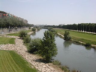
The Segre is a river tributary to the Ebro with a basin comprising territories across three states: France, Andorra, and Spain.
Puigcerdà is the capital of the Catalan comarca of Cerdanya, in the province of Girona, Catalonia, northern Spain, near the Segre River and on the border with France.
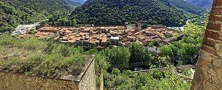
Llívia is a town in the comarca of Cerdanya, province of Girona, Catalonia, Spain. It is a Spanish exclave surrounded by the French département of Pyrénées-Orientales.
Roussillon was a historical province of France that largely corresponded to the County of Roussillon and part of the County of Cerdagne of the former Principality of Catalonia. It is part of the region of Northern Catalonia or French Catalonia, corresponding roughly to the present-day southern French département of Pyrénées-Orientales in the former region of Languedoc-Roussillon.
The Treaty of the Pyrenees was signed on 7 November 1659 and ended the Franco-Spanish War that had begun in 1635.
Cerdanya is a comarca in northern Catalonia, in the Pyrenees, on the border of Catalonia with France and Andorra. Within Catalonia, Cerdanya is divided between Catalan provinces of Girona and Lleida. Cerdanya's neighbouring comarques are Alt Urgell, Berguedà, and Ripollès.
The Pyrénées-Orientales department is composed of 226 communes.
French Cerdagne is the northern half of Cerdanya, which came under French control as a result of the Treaty of the Pyrenees in 1659, while the southern half remained in Spain. Catalans often refer to French Cerdagne as Upper Cerdanya. It is the only French territory on the Iberian Peninsula, as it is located on the south side of the Pyrenees Range between France and Spain. For example, the Segre river, which goes west and then south to meet the Ebro, has its source in the French Cerdagne. An inadvertent result of the Treaty of the Pyrenees is the Spanish exclave of Llívia which is sovereign Spanish territory surrounded by French Cerdagne.
Northern Catalonia, North Catalonia or French Catalonia is the formerly Catalan-speaking and cultural territory ceded to France by Spain through the signing of the Treaty of the Pyrenees in 1659 in exchange of France's effective renunciation on the formal protection that it had given to the recently founded Catalan Republic. The area corresponds roughly to the modern French département of the Pyrénées-Orientales which were historically part of Catalonia since the old County of Barcelona, and lasted during the times of the Crown of Aragon and the Principality of Catalonia until they were given to France by Spain.
Font-Romeu-Odeillo-Via, or simply Odeillo, is a commune in the Pyrénées-Orientales and Cerdagne near the Spanish border in the south of France. It comprises the villages of Odeillo and Via, as well as Font-Romeu, one of the oldest ski resorts in France and the oldest in the Pyrenees.
Villefranche-de-Conflent is historically a town in the Conflent region of Catalonia, and now a commune in the Pyrénées-Orientales department in southern France. It is a member of Les Plus Beaux Villages de France Association.
The County of Roussillon was one of the Catalan counties in the Marca Hispanica during the Middle Ages. The rulers of the county were the counts of Roussillon, whose interests lay both north and south of the Pyrenees.
Bourg-Madame is a commune in the Pyrénées-Orientales department in southern France.
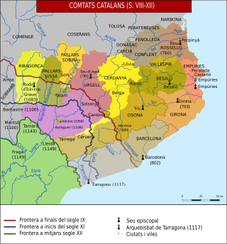
The County of Cerdanya was one of the Catalan counties formed in the last decades of the 8th century by the Franks in the Marca Hispanica. The original Cerdanya consisted of the valley of the upper Segre. Today Cerdanya is a Catalan comarca.
The County of Conflent or Confluent was one of the Catalan counties of the Marca Hispanica in the ninth century. Usually associated with the County of Cerdanya and the county of Razès, it was located to the west of Roussillon. It largely corresponded to the modern comarca of Conflent.
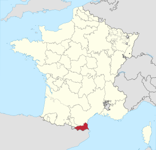
Pyrénées-Orientales, also known as Northern Catalonia, are a department of the region of Occitania, Southern France, adjacent to the northern Spanish frontier and the Mediterranean Sea. It borders the departments of Ariège to the northwest and Aude to the north, the Mediterranean Sea to the east and the Spanish province of Girona in Catalonia to the south and the country of Andorra to the west. It also surrounds the tiny Spanish exclave of Llívia, and thus has two distinct borders with Spain. In 2019, it had a population of 479,979. Some parts of the Pyrénées-Orientales are part of the Iberian Peninsula. It is named after the Pyrenees mountain range.
Occitania is the southernmost administrative region of metropolitan France excluding Corsica, created on 1 January 2016 from the former regions of Languedoc-Roussillon and Midi-Pyrénées. The Council of State approved Occitania as the new name of the region on 28 September 2016, coming into effect on 30 September 2016.
The Angelets, or “the Angelets of the Land”, were peasants who rose up in peasant revolts from 1667 to 1675 against the French authorities in Roussillon; the group of conflicts of the period is called the Revolt of the Angelets. The cause was the institution of the gabelle, a tax on salt, in 1661—a measure contrary to traditional constitutions of the earldom. The revolt first concerned the county of Vallespir, then it spread to those of Conflent and Roussillon.
The canton of Les Pyrénées catalanes is an administrative division of the Pyrénées-Orientales department, in Southern France. It was created at the French canton reorganisation which came into effect in March 2015. Its seat is in Prades.
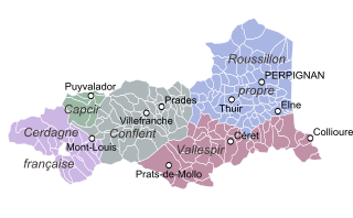
Northern Catalonia is traditionally divided into five historical comarques (counties). These counties formed part of the Principality of Catalonia until the territory was incorporated into France following the Treaty of the Pyrenees, with Cerdanya county split between Spain and France. After the French Revolution, the current department of Pyrénées-Orientales was created, comprising the Northern Catalan counties along with part of the Occitan parçan of Fenouillèdes (Fenolhedés).