Puigcerdà is the capital of the Catalan comarca of Cerdanya, in the province of Girona, Catalonia, northern Spain, near the Segre River and on the border with France.

Cerdanya or often La Cerdanya is a natural comarca and historical region of the eastern Pyrenees divided between France and Spain. Historically it was one of the counties of Catalonia.

The Treaty of the Pyrenees was signed on 7 November 1659 and ended the Franco-Spanish War that had begun in 1635.

Cerdanya is a comarca in northern Catalonia, in the Pyrenees, on the border of Catalonia with France and Andorra. Within Catalonia, Cerdanya is divided between Catalan provinces of Girona and Lleida. Cerdanya's neighbouring comarques are Alt Urgell, Berguedà, and Ripollès.

French Cerdagne is the northern half of Cerdanya, which came under French control as a result of the Treaty of the Pyrenees in 1659, while the southern half remained in Spain. Catalans often refer to French Cerdagne as Upper Cerdanya. It is the only French territory on the Iberian Peninsula, as it is located on the south side of the Pyrenees Range between France and Spain. For example, the Segre river, which goes west and then south to meet the Ebro, has its source in the French Cerdagne. An inadvertent result of the Treaty of the Pyrenees is the Spanish exclave of Llívia which is sovereign Spanish territory surrounded by French Cerdagne.

Northern Catalonia, North Catalonia or French Catalonia is the formerly Catalan-speaking and cultural territory ceded to France by Spain through the signing of the Treaty of the Pyrenees in 1659 in exchange of France's effective renunciation on the formal protection that it had given to the recently founded Catalan Republic. The area corresponds roughly to the modern French département of the Pyrénées-Orientales which were historically part of Catalonia since the old County of Barcelona, and lasted during the times of the Crown of Aragon and the Principality of Catalonia until they were given to France by Spain.

Premià de Mar is a municipality in the comarca of the Maresme in Catalonia. It is situated on the coast between El Masnou and Vilassar de Mar, to the north-east of Barcelona. The town is both a tourist centre and a dormitory town for Barcelona.
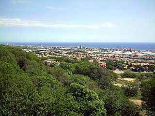
Vilassar de Mar is a municipality in the comarca of the Maresme in Catalonia, Spain. It is situated on the coast between Premià de Mar and Cabrera de Mar, to the north-east of Barcelona. The town is both a tourist centre and a dormitory town for Barcelona, and is also known for its horticulture. The main N-II road and a RENFE railway line run through the town, while a local road connects the municipality with the C-32 autopista at Vilassar de Dalt and Mataró and Barcelona. The famous canned food company DANI is based in Vilassar de Mar coming from a Vilassar family.

Sant Llorenç de Morunys is a municipality in the comarca of the Solsonès in Catalonia, Spain. It is situated in the Lord valley in the north of the comarca below the pyrenean massif of Port del Comte. The shrine of Lord is located in an exclave of the municipality between Guixers and Navès. The town is served by the L-401 road between Coll de Nargó and Berga.

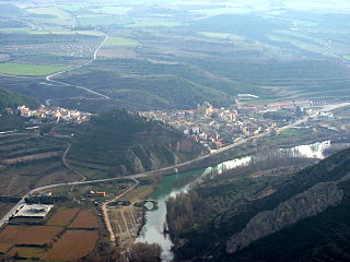
Organyà is a municipality in the comarca of the Alt Urgell in Catalonia. It is situated on the right bank of the Segre river below the Trespons gorge, and is served by the C-14 road between Ponts and La Seu d'Urgell. There is a monument to the Homilies d'Organyà, a 12th or 13th century collection of sermons which is the oldest literary text in the Catalan language to survive in its entirety, discovered in the town in 1904.

Castellar de n'Hug is a municipality in the comarca of the Berguedà in Catalonia, Spain. It is situated on the southern slopes of the pyrenean range of the Creueta. The Llobregat river has its source on the territory of the municipality. The village is served by the B-403 road, which links it with La Pobla de Lillet and which continues over the Creueta to the comarques of the Ripollès and the Cerdanya.
Camarasa is a municipality in the comarca of the Noguera in Catalonia, Spain. It is situated at the confluence of the Segre and Noguera Pallaresa rivers. The Camarasa reservoir on the Noguera Pallaresa (113 hm³) and the Sant Llorenç de Montgai reservoir on the Segre are important hydroelectric power stations.

Agramunt is a municipality (municipi) in the comarca of the Urgell in Catalonia. It is situated in the north of the comarca, near the border with the Noguera. The town centre is protected as a historic-artistic monument, especially the Roman church of Santa Maria which dates from the 12th-13th centuries. The town is also known for the production of torró d'Agramunt, a sort of confectionery traditionally eaten at Christmas. The town is linked to Tàrrega by the C-240 road, to Cervera by the L-303 road and to Artesa de Segre by the L-302 road. The Urgell canal passes through the municipality, crossing the Montclar range through a tunnel. The municipality includes the exclave of Montclar d'Urgell to the north-west.

Borredà is a municipality in the comarca of the Berguedà in Catalonia, Spain. It is situated in the upper valley of the Margençol river in the east of the comarca. There are several notable houses from the 17th and 18th centuries. The Romanesque church of Sant Sadurní de Rotgers, a protected historico-artistic monument, can be reached by a mountain track. The village is served by the C-149 road between Berga and Sant Quirze de Besora. The municipality surrounds an exclave of Les Llosses.

Sant Jaume de Frontanyà is a municipality in the comarca of the Berguedà in Catalonia, Spain. It is situated in the Pyrenees below the peak of Pedró de Tubau (1543 m). The village was the smallest municipality in Catalonia in terms of population but in 2018 lost the title to Gisclareny after the village grew. The monumental Romanesque church of Sant Jaume is a protected historic-artistic monument from the 11th century. The village is served by a local road to Borredà and it is well known for its peace and tranquility.

Prats i Sansor is a municipality in the comarca of Cerdanya, province of Lleida, Catalonia, Spain. It is composed by four villages, Prats, Sansor, Capdevila and El Pla.

Guils de Cerdanya is a municipality in the comarca of Cerdanya, province of Girona, Catalonia, Spain.

Meranges is a village in the comarca of Cerdanya, province of Girona, Catalonia, north-eastern Spain.

Lles de Cerdanya is a Pyrrenean village in the comarca of Cerdanya, province of Lleida, Catalonia, north-eastern Spain. It is located south of the border with Andorra and France and home to two ski resorts, Lles and Aransa.

The France–Spain border was formally defined in 1659. It separates the two countries from Hendaye and Irun in the west, running through the Pyrenees to Cerbère and Portbou on the Mediterranean Sea. It runs roughly along the drainage divide defined by the Pyrenees, though with several exceptions.