Olot is the capital city of the comarca of Garrotxa, in the Province of Girona, Catalonia, Spain. The city is known for its natural landscape, including four volcanoes scattered around the city center. The municipality is part of the Zona Volcànica de la Garrotxa Natural Park. Olot is also well known for its cultural activity, with historical art movements like Olot school or factories of religious imagery, which contributed to the location in the city of the main Design and Arts & Crafts school of the province of Girona, the Escola d'Art i Superior de Disseny d'Olot.

Cassà de la Selva is a municipality in the comarca of the Gironès in Catalonia, It is linked to Girona and to the Baix Empordà by the C-65 road. During the 20th century it was known for the production of cork and derived articles. With an increasing population of 9,200 citizens, this municipality is located 12 km south of Girona and 20 km west of the Mediterranean Sea.

Santa Cristina d'Aro is a small town in the Aro river valley at the junction of the road from Girona/Barcelona to Sant Feliu de Guíxols and Palamós. It is home to a number of workers in the nearby holiday resorts. The Costa Brava golf course is on the outskirts of the town.

Sant Pere Pescador is a municipality in the comarca of Alt Empordà, Girona, Catalonia, Spain, is a small town in the Bay of Roses on the river Fluvià, on the coastline of the Costa Brava.

Sant Mori is a municipality in the comarca of Alt Empordà, Girona, Catalonia, Spain.

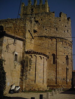
Torroella de Fluvià is a municipality in the comarca of Alt Empordà, Girona, Catalonia, Spain. It includes the village of Vilacolum. The 11th Century Church of Sant Tomàs de Fluvià is a notable romanesque landmark.

Vilamacolum is a municipality and village in the comarca of Alt Empordà, Girona, Catalonia. It is on the left side of the Fluvià river, in a flat land. The local economy is based on agriculture and tourism.

Castellfollit de la Roca is a municipality in the comarca of Garrotxa, in the Province of Girona, Catalonia, Spain. The urban area is bordered by the confluence of the Fluvià and Toronell rivers, between which the town's basalt cliff rises.
Sant Joan les Fonts is a municipality of the comarca of Garrotxa, located in Girona, Catalonia, northern Spain. As of 2014, the population is 2,919. Until 1949 it was known as Begudà.

Sant Pere de Galligants is Benedictine abbey in Girona, Catalonia. Since 1857, it is home to the Archaeology Museum of Catalonia venue in the city. The name translates to English as "Saint Peter of Galligants", where Galligants refers to the River Galligants that runs past the abby.

Amer is a municipality in the comarca of la Selva in the province of Girona, Catalonia, Spain.

Cruïlles, Monells i Sant Sadurní de l'Heura is a Spanish municipality of the Province of Girona, situated in the comarca (county) of Baix Empordà (Catalonia), formed in 1973 by merging the municipalities of Cruïlles, Monells, and Sant Sadurní de l'Heura. Sant Sadurní is the capital of the municipality. According to the 2014 census, the municipality has a population of 1,284 inhabitants.

Llagostera is a municipality in the comarca of the Gironès in Catalonia, Spain. During the 20th century, it was known for the production of cork and derived articles. It is located 20 km south of Girona and 15 km west from the Mediterranean Sea.

Llambilles is a village in the province of Girona and autonomous community of Catalonia, Spain. The municipality covers an area of 14.55 square kilometres (5.62 sq mi), and the population in 2014 was 738.

Les Planes d'Hostoles is a village and municipality in the province of Girona and autonomous community of Catalonia, Spain. The municipality covers an area of 37.51 square kilometres (14.48 sq mi) and the population in 2014 was 1,694.
Quart is a village in the province of Girona and autonomous community of Catalonia, Spain. The municipality covers an area of 38.1 square kilometres (14.7 sq mi) and the population in 2014 was 3,441.

Sant Feliu de Pallerols is a village in the province of Girona and autonomous community of Catalonia, Spain. The municipality covers an area of 34.8 square kilometres (13.4 sq mi) and the population in 2014 was 1,353.

{{Infobox settlement | name = Sant Miquel de Campmajor | settlement_type = Municipality | image_skyline = Sant-Miquel-de-Campmajor.jpg | image_alt = | image_caption = Parish church | image_flag = Bandera de Sant Miquel de Campmajor.svg | flag_alt = | image_seal = | seal_alt = | image_shield = Escut de Sant Miquel de Campmajor.svg | shield_alt = | nickname = | motto = | image_map = | map_alt = | map_caption = | pushpin_map = Spain Province of Girona#Spain | pushpin_label_position = | pushpin_map_alt = | pushpin_map_caption = Location in Catalonia | coordinates = 42°8′15″N2°40′48″E | coor_pinpoint = | coordinates_footnotes = | subdivision_type = Country | subdivision_name = Spain | subdivision_type1 = Community | subdivision_name1 = Catalonia | subdivision_type2 = [[Pr Gironaovinces of Spain|Province]] | subdivision_name2 = | subdivision_type3 = Comarca | subdivision_name3 = Pla de l'Estany | established_title = | established_date = | founder = | seat_type = | seat = | government_footnotes = | leader_party = | leader_title = Mayor | leader_name = Josep Fort Olivella (2015) | unit_pref = Metric | area_footnotes = | area_urban_footnotes = | area_rural_footnotes = | area_metro_footnotes = | area_magnitude = | area_note = | area_water_percent = | area_rank = | area_blank1_title = | area_blank2_title = | area_total_km2 = 33.2 | area_land_km2 = | area_water_km2 = | area_urban_km2 = | area_rural_km2 = | area_metro_km2 = | area_blank1_km2 = | area_blank2_km2 = | dimensions_footnotes = | elevation_footnotes = | elevation_m = | population_as_of = 2018 | population_footnotes = | population_total = 228 | population_density_km2 = auto | population_demonym = | population_note = | postal_code_type = | postal_code = | area_code_type = | area_code = | iso_code = | website = santmiqueldecampmajor.cat | footnotes = }} Sant Miquel de Campmajor is a village in the province of Girona and autonomous community of Catalonia, Spain. The municipality covers an area of 33.2 square kilometres (12.8 sq mi) and the population in 2014 was 232.

Sarrià de Ter is a village in the province of Girona and autonomous community of Catalonia, Spain. It is part of the metropolitan area of the city of Girona.
Sant Miquel may refer to: