Chadiapada

Last updated

Chadiapada
Village
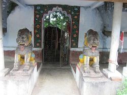
CHDPTHAKURANITMPL.JPG
ଠାକୁରାଣୀ ମନ୍ଦିର
India Orissa location map.svg
Red pog.svg
Chadiapada
Coordinates: 19°40′54″N84°47′43″E / 19.6816266°N 84.7952056°E / 19.6816266; 84.7952056 Coordinates: 19°40′54″N84°47′43″E / 19.6816266°N 84.7952056°E / 19.6816266; 84.7952056
CountryFlag of India.svg  India
State Odisha
District Ganjam
Block Polasara
Gram Panchayat Khanduru
Population
 (2011)
  Total1,001
Language
  Official Oriya
Time zone IST
PIN
761105

Chadiapada is a small village in Ganjam district of Odisha, India.

Contents

Geography

Chadiapada is located at 19°40′54″N84°47′43″E / 19.6816266°N 84.7952056°E / 19.6816266; 84.7952056 . [1] It has an average elevation of 61 meters (200 feet). It is situated at 67 km from Brahmapur on North, 3 km from Polasara on the South-West. Polasara - Asika road passes through this village.

Demographics

Temples

Education

Chadiapada has two Upper Primary Schools and one Middle English School.

Economy

Most people of this village are farmers and textile mill workers in Surat. A few are government and private sector employees. Most of the Brahmins of this village perform priestly services.

Transport

The nearest town is Polasara (around 155 km from state capital Bhubaneswar). It is well connected by road with various cities and towns like Bhubaneswar, Asika, Berhampur and Buguda. Frequent bus services are available to all the above cities.[ citation needed ]

Related Research Articles

Asika Town in Odisha, India

Asika or Aska is a town and a Notified Area Council in Ganjam district in the state of Odisha, India. Fondly known as the sugar city of India. Asika is the 3rd largest city in district of Ganjam after Berhampur and Bhanjanagar. Asika is a major commercial and transportation hub of Ganjam district. It is situated between river Badanadi and holy river Rushikuliya.

Dadhapatna Town in Odisha, India

Dadhapatna is a census town in Barang, Cuttack district in the state of Odisha, India.

Dinhata City in West Bengal, India

Dinhata is a city and a municipality in Cooch Behar district in the state of West Bengal, India. It is the headquarters of the Dinhata subdivision.

Hirekerur city in Karnataka, India

Hirekeruru is a panchayat town in Haveri district in the Indian state of Karnataka. The name "the village of the big pond". The name is pronounced as "Hee ray kay roor".

Jaleswar Town in Odisha, India

Jaleswar is a small town that belongs to Balasore district of state Odisha and is near to border of West Bengal. 'Jaleswar' town is a Municipality. Jaleswar block consists of 144 villages and Jaleswar town (municipality) forms a state constituency along with Balipal Block.

Jemari village in West Bengal, India

Jemari is a village in Salanpur CD Block in Asansol Sadar subdivision of Paschim Bardhaman district in the state of West Bengal, India.

Mukhiguda Town in Odisha, India

Mukhiguda is a census town in Kalahandi district in the Indian state of Odisha. Mukhiguda is one of the villages in Jayapatna tehsil. Mukhiguda is 7 km from its tehsil's main town, Jaipatna, is located 87 km from its district's main city, Bhawanipatna, and is located 510 km (320 mi) from its state's main city Bhubaneswar.

Polasara Town in Odisha, India

Polasara is a town and a notified area council in Ganjam district in the Indian state of Odisha.

Taki (India) City in West Bengal, India

Taki is a city and a municipality under Hasnabad police station of Basirhat subdivision in North 24 Parganas district in the Indian state of West Bengal.

Keshabpur Upazila Upazila in Khulna Division, Bangladesh

Keshabpur is an Upazila of Jessore District in the Division of Khulna, Bangladesh.

Mohanpur Upazila Upazila in Rajshahi Division, Bangladesh

Mohanpur is an Upazila of Rajshahi District in the Division of Rajshahi, Bangladesh.

Mahagaon, Gadhinglaj Town in Maharashtra, India

Mahagaon is a town in Gadhinglaj Taluka, Kolhapur district, situated in the southwest corner of the state of Maharashtra, India, on the banks of the Hiranyakeshi river. It is about 10 kilometres (6.2 mi) south of Gadhinglaj and 14 kilometres (8.7 mi) from the city of Kadgaon. It is managed by a town council. In 2011, it had a population of about 20,108.

Golia, Ganjam Rural area in Odisha, India

Golia is a village located in the Ganjam District of the Indian state of Odisha. It is governed by a panchayat, which also governs several nearby villages, and is famous for the large number of turtles in Nelia Pond beside the temple of Shiva. Golia is 76 kilometres (47 mi) away from the city of Brahampur and 159 kilometres (99 mi) away from the state capital, Bhubaneswar.

Belwania, Bihar Village in Bihar, India

Belwania is a village in West Champaran district in the Indian state of Bihar.

Mathura, Bihar Village in Bihar, India

Mathura is a village in West Champaran district in the Indian state of Bihar. Specially recognized for champaran meat.

Mujagada, Ganjam town in Odisha, India

Mujagada is a small town located near Bhanjanagar of Ganjam district in Orissa. It is located 89 km towards North from District Headquarters Chhatrapur. 159 km from State capital Bhubaneswar. Asika, Hinjilicut, Phulabani, Berhampur are the nearby Cities of the village. Oriya is the local language here. The nearest town Bhanjanagar present about 13 KM away from it. The main occupation of this village is agriculture.

Baunsalundi, Ganjam village in Odisha, India

Baunsalundi is a small village located near Bhanjanagar of Ganjam district in Orissa. It is located 91 km towards North from District Headquarters Chhatrapur. 162 km from State capital Bhubaneswar.. Oriya is the Language here.

Rurka Khurd is a large size village in Phillaur tehsil of Jalandhar District of Punjab State, India. Kalan is Persian language word which means Big and Khurd is Persian word which means small when two villages have same name then it is distinguished with Kalan means Big and Khurd means Small used with Village Name. It is located 1.6 km away from postal head office Goraya, 16.7 km from Phillaur, 35 km from district headquarter Jalandhar and 129 km from state capital Chandigarh. The village is administrated by a sarpanch who is an elected representative of village as per Panchayati raj (India). The man in the photograph is native to this village. It was his first time getting his picture taken as well. He is a cattle herder. His name is Jattmandeep Singh and has a rich knowledge of the village

Karui Village in West Bengal, India

Karui is a village in Katwa II CD block in Katwa subdivision of Purba Bardhaman district of West Bengal state in East India. The meaning of Karui is Grain Storage.

Kulei Village in Odisha, India

Kulei is a traditional Indian village belongs to Angul district of Odisha. Kulei is the 6th most populous village in Samal Barrage sub district of Angul district.Total geographical area of the village is 3 km² and area wise 17th largest village in the sub district. Population density of Kulei is 516 person per km². 0.54 km²(19%) of which is covered with forest.

References

  1. Falling Rain Genomics, Inc - Polasara
  2. "Census of India 2011: View Population Details - Chadhiapadakrushnadaspur". Census Commission of India. Archived from the original on 18 August 2016.
  3. "Census of India 2001: View Population Details - Chadhiapadakrushnadaspur".