Chalfont Viaduct

Last updated

Chalfont Viaduct
Give Peas A Chance - geograph.org.uk - 1723109.jpg
Chalfont Viaduct seen from the M25 (in 2009)
Coordinates 51°34′56″N0°32′04″W / 51.58231°N 0.53458°W / 51.58231; -0.53458
OS grid reference TQ 01633 88067
Carries Chiltern Main Line
Crosses M25 Motorway
Locale Gerrards Cross
Official nameChalfont No. 1 Viaduct
Other name(s)Misbourne Viaduct
Named for The Chalfonts (Chalfont St Giles, Chalfont St Peter, Little Chalfont)
Owner Network Rail
Characteristics
Design Arch
MaterialBlue/black engineering brick
Total length104 metres (114 yd)
Height12.5 metres (41 ft)
No. of spans5, each 15.5 metres (51 ft) wide
Rail characteristics
No. of tracks 2
Track gauge 4 ft 8+12 in (1,435 mm) standard gauge
History
Designer James Charles Inglis, R.C. Sikes
Construction start1902
Construction end1906
Location
Chalfont Viaduct

The Chalfont Viaduct (also known as the Misbourne Viaduct) is the first of two five-arch brick railway viaducts on the Chiltern Main Line in south-east England. It is located between Gerrards Cross and Denham Golf Club stations. The M25 motorway passes beneath it between junctions 16 and 17 at Gerrards Cross near Chalfont St Peter, from where the bridge gets its name. The bridge is known as Chalfont No. 1 Viaduct; the longer Chalfont No. 2 Viaduct is a short distance to the west and spans the A413. [1]

Contents

The bridge is noted as a local landmark because for many years it bore a graffiti slogan, "give peas a chance" painted in large white letters on the south-facing parapet. [2] [3] As of March 2024, it bears the slogan "helta▪skelta" (added in 2021).

Construction

The River Misbourne diverted via culverts under the M25 River Misbourne, M25 Motorway culvert - geograph.org.uk - 803224.jpg
The River Misbourne diverted via culverts under the M25

The Chalfont Viaduct is built of blue and black engineering brick with additional decorative brickwork. The bridge is approximately 12.5 metres (41 ft) high, although it varies in height due to changing ground level, and it has five semi-elliptical arches, each 15.5 metres (51 ft) wide. It was constructed between 1902 and 1906 by the Great Western Railway (GWR) to carry trains on the Great Western and Great Central Joint Railway between London and High Wycombe across the River Misbourne. [4] [5] It was designed by James Charles Inglis, chief civil engineer of the GWR, and assistant engineer Robert Cherry Sikes. [6]

In the mid-1980s the construction of the M25 motorway required the Misbourne to be diverted via underground concrete culverts. The route of the motorway was aligned to pass through the arches of the Chalfont Viaduct, leaving the viaduct largely unaltered apart from the raised ground level and the addition of concrete supports and crash barriers. The viaduct is the only brick-built bridge on this section of the M25. [5]

Graffiti

The new "
give helch a break!!!" graffiti slogan added in 2018 Chalfont Viaduct - Give Helch a Break.jpg
The new "give helch a break!!!" graffiti slogan added in 2018

Between 2008 and 2018, the Chalfont Viaduct bore a graffiti slogan, "give peas a chance" painted in large white letters on the south-facing parapet, visible to M25 drivers heading in a clockwise direction. The north side of the bridge bears the painted legend "peas06". [2]

Originally, the graffiti on the south parapet simply read "peas". It is thought that "Peas" was the tag of a London graffiti artist which can be seen on other locations. Google Streetview images suggest the words "give" and "a chance" were added at some point between June and November 2008; it is unclear whether these were painted by the same person as peas. The altered slogan may refer to the artist being repeatedly arrested, and it may also be a play on words in reference to John Lennon's popular 1969 song, "Give Peace a Chance". [7] [4] [8]

The graffiti became a popular local landmark and was regarded affectionately by motorists and residents in nearby settlements as a reassuring location marker. In 2018, when the graffiti was partially removed and altered by an unknown artist to read "helch, a chance taken", [9] it prompted mass media commentary which lead to the new artist returning a few days later to change the slogan to "give helch a break!!!". [10] [11] It has been speculated that the new graffiti may be related to similar slogans being painted on buildings in the London borough of Harrow, [12] and several other bridges along the M25 and M1 motorways all following the similar, heavily serif-ed style/typeface. The reception towards this modification was largely negative, to the point that a petition to Network Rail to reinstate the previous slogan and make the bridge a listed building was produced, and received over 2,000 signatures. [13]

Thank You NHS Graffiti that appeared in March 2020. NHSCharfontViaduct Aug2020.png
Thank You NHS Graffiti that appeared in March 2020.

In March 2020 during the coronavirus pandemic, an unknown artist replaced the graffiti with one reading "thank you NHS ". [14]

The "
helta#skelta" graffiti slogan, which first appeared in 2021. Chalfont Viaduct "HELTA-SKELTA" 4-4-2024.jpg
The "helta▪skelta" graffiti slogan, which first appeared in 2021.

At some point between July and November 2021, the graffiti was replaced again with "helta▪skelta".

The north side of the bridge, visible to drivers going in an anticlockwise direction was tagged with graffiti from Extinction Rebellion. [15] [ better source needed ].

See also

Related Research Articles

<span class="mw-page-title-main">M25 motorway</span> Circular motorway around Greater London

The M25 or London Orbital Motorway is a major road encircling most of Greater London. The 117-mile (188-kilometre) motorway is one of the most important roads in the UK and one of the busiest. Margaret Thatcher opened the final section in 1986, making the M25 the longest ring road in Europe upon opening. The Dartford Crossing completes the orbital route but is not classed as motorway; it is classed as a trunk road and designated as the A282. In some cases, including notable legal contexts such as the Communications Act 2003, the M25 is used as a de facto alternative boundary for Greater London.

<span class="mw-page-title-main">Dartford Crossing</span> Tunnel and bridge between Kent and Essex, UK

The Dartford–Thurrock River Crossing, commonly known as the Dartford Crossing and until 1991 the Dartford Tunnel, is a major road crossing of the River Thames in England, carrying the A282 road between Dartford in Kent in the south and Thurrock in Essex in the north.

<span class="mw-page-title-main">Amersham</span> Human settlement in England

Amersham is a market town and civil parish in Buckinghamshire, England, in the Chiltern Hills, 27 miles (43 km) northwest of central London, 15 miles (24 km) south-east of Aylesbury and 9 miles (14 km) north-east of High Wycombe. Amersham is part of the London commuter belt.

<span class="mw-page-title-main">M1 motorway</span> First inter-urban motorway in the UK

The M1 motorway connects London to Leeds, where it joins the A1(M) near Aberford, to connect to Newcastle. It was the first inter-urban motorway to be completed in the UK; the first motorway in the country was the Preston Bypass, which later became part of the M6.

<span class="mw-page-title-main">A413 road</span> Road in Buckinghamshire and Northamptonshire

The A413 is a major road in England that runs between Denham to Towcester. It passes through or near various towns and villages including Gerrards Cross, Chalfont St Peter, Chalfont St Giles, Amersham, Little Missenden, Great Missenden, Wendover, Aylesbury, Winslow, and Buckingham. Most of the road is in Buckinghamshire, with a part at the north end in Northamptonshire.

<span class="mw-page-title-main">M40 motorway</span> British motorway connecting London and Birmingham

The M40 motorway links London, Oxford, and Birmingham in England, a distance of approximately 89 miles (143 km).

<span class="mw-page-title-main">Chalfont St Peter</span> Village and civil parish in Buckinghamshire, England

Chalfont St Peter is a large village and civil parish in southeastern Buckinghamshire, England. It is in a group of villages called The Chalfonts which also includes Chalfont St Giles and Little Chalfont. The villages lie between High Wycombe and Rickmansworth. Chalfont St Peter is one of the largest villages, with nearly 13,000 residents. The urban population for Chalfont St Peter and Gerrards Cross is 19,622, the two villages being considered a single area by the Office for National Statistics.

<span class="mw-page-title-main">Gerrards Cross</span> Human settlement in England

Gerrards Cross is a town and civil parish in south Buckinghamshire, England, separated from the London Borough of Hillingdon at Harefield by Denham, south of Chalfont St Peter and north bordering villages of Fulmer, Hedgerley, Iver Heath and Stoke Poges. It spans foothills of the Chiltern Hills and land on the right bank of the River Misbourne. It is 19.3 miles (31.1 km) west-north-west of Charing Cross, central London. Bulstrode Park Camp was an Iron Age fortified encampment.

<span class="mw-page-title-main">Gerrards Cross railway station</span> Railway station in Buckinghamshire, England

Gerrards Cross railway station is a railway station in the town of Gerrards Cross in Buckinghamshire, England. It is on the Chiltern Main Line between Denham Golf Club and Seer Green and Jordans.

<span class="mw-page-title-main">River Misbourne</span> River in Buckinghamshire, England

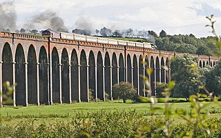
The River Misbourne rises in a field on the outskirts of Great Missenden in Buckinghamshire, passing through Little Missenden, Old Amersham, Chalfont St Giles, Chalfont St Peter and under the Chiltern railway line and the M25 motorway to its confluence with the River Colne just north of where the Colne is crossed by Western Avenue, the A40 road. It falls by around 94 m (310 ft) in the course of its 27 km (17 mi) length.

<span class="mw-page-title-main">Chiltern Main Line</span> British railway line

The Chiltern Main Line is a railway line which links London (Marylebone) and Birmingham on a 112-mile (180 km) route via High Wycombe, Bicester, Banbury, Leamington Spa and Solihull in England.

<span class="mw-page-title-main">Chesham and Amersham (UK Parliament constituency)</span> Parliamentary constituency in the United Kingdom, 1974 onwards

Chesham and Amersham is a parliamentary constituency in Buckinghamshire, South East England, represented in the House of Commons by Sarah Green, a Liberal Democrat elected at a 2021 by-election.

<span class="mw-page-title-main">Gatehampton Railway Bridge</span> Bridge in Lower Basildon, Berkshire

Gatehampton Railway Bridge, otherwise referred to as Gatehampton Viaduct, is a railway bridge carrying the Great Western Main Line over the River Thames in Lower Basildon, Berkshire, England. It takes the line between the stations at Goring and Streatley and Pangbourne, and crosses the Thames on the reach between Whitchurch Lock and Goring Lock.

<span class="mw-page-title-main">Welland Viaduct</span> Viaduct crossing the valley of the River Welland in Rutland, England

Welland Viaduct, Harringworth Viaduct or Seaton Viaduct, crosses the valley of the River Welland between Harringworth in Northamptonshire and Seaton in Rutland, England.

The North Devon Railway connected Barnstaple to the growing railway network in 1854 and as Ilfracombe developed as a watering place, it was obvious a railway connection to the town was needed. The hilly terrain was very difficult, but an Ilfracombe Railway was authorised in 1864 but failed when a major shareholder was unable to respond to a subscription call. After several false starts the Barnstaple and Ilfracombe Railway, soon taken over by the London and South Western Railway, opened in 1870.

The Great Western and Great Central Joint Railway was a railway built and operated jointly by the Great Western Railway (GWR) and Great Central Railway (GCR) between Northolt and Ashendon Junction. It was laid out as a trunk route with gentle curves and gradients and spacious track layouts. The two companies each needed approach railways at both ends of the line to connect their respective systems; these were built as part of a single project.

<span class="mw-page-title-main">James Charles Inglis</span> British civil engineer (1851–1911)

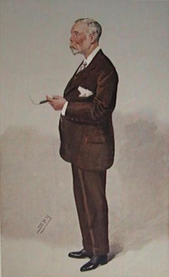
Sir James Charles Inglis was a British civil engineer.

<span class="mw-page-title-main">Smart motorway</span> Designation of roads in the United Kingdom

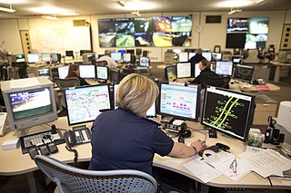
A smart motorway, also known in Scotland as an intelligent transport system, is a section of motorway in the United Kingdom that employs active traffic management (ATM) techniques to increase capacity through the use of MIDAS technology including variable speed limits and occasionally hard shoulder running and ramp metering at busy times. They were developed at the turn of the 21st century as a cost-effective alternative to traditional carriageway widening, with intended benefits ranging from more reliable journey times to lower vehicle emissions. However, despite the risk of a collision occurring between two moving vehicles being found to be decreased, there has been an acknowledged rise in the incidence of collisions involving vehicles where at least one was stationary in the first few years following the widespread removal of the hard shoulder on the country's busiest sections of motorway. Smart motorways garnered intense criticism from politicians, police representatives and motoring organisations, particularly from 2020 onwards, after a surge in near miss incidents and dozens of fatalities were revealed, and as of April 2023, no new smart motorways will be built.

<span class="mw-page-title-main">Graffiti in Russia</span>

In Russia, graffiti is an ambiguous phenomenon, i.e. considered to be desecration by some, and art by others. It is done for a variety of reasons, including expressing oneself through an art form, or protesting against a corporation or ideology.

<span class="mw-page-title-main">Thorney Interchange</span>

The Thorney Interchange is a large motorway intersection in the UK, between the M4 and M25. It is one of the busiest motorway interchanges in the country. It lies on the edges of Buckinghamshire, Greater London and Berkshire, and is close to Surrey and Staines-upon-Thames.

References

Citations

  1. Maggs 2010, p. 34.
  2. 1 2 Winterman, Tom de Castella and Denise (25 May 2011). "Campaigning by graffiti". BBC News. Archived from the original on 20 September 2018. Retrieved 20 September 2018.
  3. "Calls for M25 'give peas a chance' return". BBC News. 21 September 2018. Archived from the original on 21 September 2018. Retrieved 21 September 2018.
  4. 1 2 Hamilton 2015, p. 59.
  5. 1 2 Kelly 2009, p. 1.
  6. Kelly 2009, pp. 2–3.
  7. Kelly 2009, p. 5.
  8. "The 'Give Peas a Chance' Bridge". Atlas Obscura. Archived from the original on 20 September 2018. Retrieved 20 September 2018.
  9. Clifton, Katy (20 September 2018). "London Evening Standard" . Retrieved 1 October 2023.
  10. Clifton, Katy (20 September 2018). "Motorists devastated as iconic 'Give Peas a Chance' graffiti is erased". London Evening Standard. Archived from the original on 20 September 2018. Retrieved 20 September 2018.
  11. "'Give peas a chance' M25 graffiti removed". BBC News. 18 September 2018. Archived from the original on 20 September 2018. Retrieved 20 September 2018.
  12. "Why HELCH is appearing in giant letters on Harrow buildings". MyLondon . Retrieved 7 May 2019.
  13. "Petition calls for M25 'give peas a chance' graffiti return". BBC News. 21 September 2018. Retrieved 18 December 2019.
  14. "Coronavirus: M25 graffiti replaced with NHS thank you". BBC News. 30 March 2020. Retrieved 30 March 2020.
  15. "Google Maps".

Sources