Champdeniers-Saint-Denis

Last updated
Champdeniers-Saint-Denis
Commune

Champdeniers.JPG

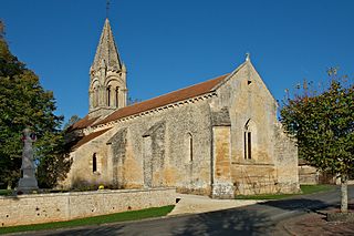
A general view of Champdeniers-Saint-Denis
Blason ville fr Champdeniers 79.svg
Coat of arms
France location map-Regions and departements-2016.svg
Red pog.svg
Champdeniers-Saint-Denis
Location within Nouvelle-Aquitaine region
Aquitaine-Limousin-Poitou-Charentes region location map.svg
Red pog.svg
Champdeniers-Saint-Denis
Coordinates: 46°29′06″N0°24′14″W / 46.485°N 0.4039°W / 46.485; -0.4039 Coordinates: 46°29′06″N0°24′14″W / 46.485°N 0.4039°W / 46.485; -0.4039
Country France
Region Nouvelle-Aquitaine
Department Deux-Sèvres
Arrondissement Niort
Canton Autize-Égray
Intercommunality Val d'Egray
Government
  Mayor (20142020) Jean-François Ferron
Area1 21.81 km2 (8.42 sq mi)
Population (2006)2 1,596
  Density 73/km2 (190/sq mi)
Time zone CET (UTC+1)
  Summer (DST) CEST (UTC+2)
INSEE/Postal code 79066 /79220
Elevation 67–171 m (220–561 ft)
(avg. 120 m or 390 ft)

1 French Land Register data, which excludes lakes, ponds, glaciers > 1 km2 (0.386 sq mi or 247 acres) and river estuaries.

2 Population without double counting : residents of multiple communes (e.g., students and military personnel) only counted once.

Champdeniers-Saint-Denis commune in the Deux-Sèvres department in the Nouvelle-Aquitaine region in western France.

The commune is a level of administrative division in the French Republic. French communes are analogous to civil townships and incorporated municipalities in the United States and Canada, Gemeinden in Germany or comuni in Italy. The United Kingdom has no exact equivalent, as communes resemble districts in urban areas, but are closer to parishes in rural areas where districts are much larger. Communes are based on historical geographic communities or villages and are vested with significant powers to manage the populations and land of the geographic area covered. The communes are the fourth-level administrative divisions of France.

Deux-Sèvres Department of France

Deux-Sèvres is a French department. Deux-Sèvres literally means "two Sèvres": the Sèvre Nantaise and the Sèvre Niortaise are two rivers which have their sources in the department.

In the administrative divisions of France, the department is one of the three levels of government below the national level, between the administrative regions and the commune. Ninety-six departments are in metropolitan France, and five are overseas departments, which are also classified as regions. Departments are further subdivided into 334 arrondissements, themselves divided into cantons; the last two have no autonomy, and are used for the organisation of police, fire departments, and sometimes, elections.

See also

Related Research Articles

Louin, Deux-Sèvres Commune in Nouvelle-Aquitaine, France

Louin is a commune in the Deux-Sèvres department in western France.

Allonne, Deux-Sèvres Commune in Nouvelle-Aquitaine, France

Allonne is a commune in the Deux-Sèvres department in the Nouvelle-Aquitaine region in western France. It is situated some 5 km southeast of Secondigny and 14 km southwest of the town of Parthenay.

La Forêt-sur-Sèvre Commune in Nouvelle-Aquitaine, France

La Forêt-sur-Sèvre is a commune in the Deux-Sèvres department in the Nouvelle-Aquitaine region in western France.

Irais Commune in Nouvelle-Aquitaine, France

Irais is a commune in the Deux-Sèvres department in western France.

Juscorps Commune in Nouvelle-Aquitaine, France

Juscorps is a commune in the Deux-Sèvres department in western France.

Lageon Commune in Nouvelle-Aquitaine, France

Lageon is a commune in the Deux-Sèvres department in western France.

Limalonges Commune in Nouvelle-Aquitaine, France

Limalonges is a commune in the Deux-Sèvres department in western France.

Luché-sur-Brioux Commune in Nouvelle-Aquitaine, France

Luché-sur-Brioux is a commune in the Deux-Sèvres department in western France.

Maisontiers Commune in Nouvelle-Aquitaine, France

Maisontiers is a commune in the Deux-Sèvres department in western France.

Melleran Commune in Nouvelle-Aquitaine, France

Melleran is a commune in the Deux-Sèvres department in western France.

Moncoutant Commune in Nouvelle-Aquitaine, France

Moncoutant is a commune in the Deux-Sèvres department in western France.

La Petite-Boissière Commune in Nouvelle-Aquitaine, France

La Petite-Boissière is a commune in the Deux-Sèvres department in western France.

Pougne-Hérisson Commune in Nouvelle-Aquitaine, France

Pougne-Hérisson is a commune in the Deux-Sèvres department in western France.

Surin, Deux-Sèvres Commune in Nouvelle-Aquitaine, France

Surin is a commune in the Deux-Sèvres department in western France.

Thénezay Commune in Nouvelle-Aquitaine, France

Thénezay is a commune in the Deux-Sèvres department in western France.

Vasles Commune in Nouvelle-Aquitaine, France

Vasles is a commune in the Deux-Sèvres department in western France.

Vautebis Commune in Nouvelle-Aquitaine, France

Vautebis is a commune in the Deux-Sèvres department in western France.

Verruyes Commune in Nouvelle-Aquitaine, France

Verruyes is a commune in the Deux-Sèvres department in western France.

Le Vert, Deux-Sèvres Commune in Nouvelle-Aquitaine, France

Le Vert is a commune in the Deux-Sèvres department in western France. It is around 25 km south of Niort.

Villemain Commune in Nouvelle-Aquitaine, France

Villemain is a commune in the Deux-Sèvres department in western France.

References