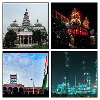
Begusarai is the industrial and financial capital of Bihar and the administrative headquarters of the Begusarai district, which is one of the 38 districts of the Indian state of Bihar. The district lies on the northern bank of the river Ganges in the Mithila region of India.

Munger, formerly spelt as Monghyr, is a twin city and a Municipal Corporation situated in the Indian state of Bihar. It is the administrative headquarters of Munger district and Munger Division. Munger was one of the major cities in Eastern India and undivided Bengal during Mughal period and British Raj. It is one of the major political, cultural, educational and commercial center of Bihar and Eastern India. Munger is situated about 180km from east of capital city Patna, about 480km west of Eastern India's largest city Kolkata and 1200km from country's capital New Delhi.

Patna district is one of the thirty-eight districts of Bihar state in eastern India. Patna, the capital of Bihar, is the district headquarters. The Patna district is a part of Patna division. The Patna district is divided into 6 Sub-divisions (Tehsils) i.e. Patna Sadar, Patna City, Barh, Masaurhi, Danapur and Paliganj.
Samastipur is one of the thirty-eight districts of Bihar in India. The district headquarters are located at Samastipur. The district occupies an area of 2904 km² and has a population of 4,261,566.

Sheikhpura district is one of the thirty-eight districts of the Indian state of Bihar. Sheikhpura is the administrative headquarter of this district. Sheikhpura district is a part of the Munger division. Sheikhpura was split from the Munger district into a separate district with headquarters in Sheikhpura on 31 July 1994 by Rajo Singh. As of 2011 it was the least populous district of Bihar.

Begusarai District is one of the thirty-eight districts of the Indian state of Bihar. The city of Begusarai is its administrative headquarters and is part of the Munger division.

Munger district is one of the thirty-eight districts of Bihar state in eastern India. The city of Munger is the administrative headquarters of this district. The district is a part of Munger Division. Its literacy rate of 73.3% is higher than the state literacy rate of 63.8%, but lower than national rate of 74.04%.

Barauni IOC Township is a census town at Barauni in Begusarai district in the state of Bihar, India.
Rosera is a town (subdivision) on the bank of River Budhi Gandak. It is a municipality in Samastipur district in the Indian state of Bihar. Rosera block consists of 48 villages. Rosera is well connected by the rest of the country through railway or road network. Rosera is connected to Begusarai district via SH-55 and Darbhanga district via SH-88 and it's approx 120km from Capital Patna.
Meghaul is a panchayat village of Khodabandpur taluk, Begusarai district, in the Indian state of Bihar.
Mortar is a village in the Garhpura block of Begusarai district in the Indian state of Bihar about 32.5 km (20.2 mi) north of district capital, Begusarai. The 2011 census gives its population as 1,817. It comes under Malipur Panchayat and under post office Malipur.
Manjhaul is a village in the Begusarai district of Bihar state in India. It is notable for the Jaimangla Garh temple and Kaber Lake.
Subhanpur village is located in Kashi Chak Tehsil of Nawada district in Bihar, India. It is situated 6 km away from sub-district headquarter Kashi Chak and 40 km away from the district headquarter Nawada. As per 2009 stats, Subhanpur village is itself a gram panchayat. According to 2011 census information the location code or village code of Subhanpur village is 257666.
Nayatol is a village located in Begusarai District, Bihar, India. It is one among the 38 villages of Mansurchak.
Partapnagar is a village in Naugachhia Block, Bhagalpur District, Bihar, India. It is located on the north of Bhagalpur District, about 20 kilometres northeast of the district capital Bhagalpur, and 2 kilometres northwest of the block capital Naugachhia. In the year 2011, it had a population of 35,878.
Rani is a village in the state of Bihar, India. It is part of Begusarai District, situating along the National Highway 122. The population of the village was 34,772 as of the 2011 census.
Pundarakh is a city under the administration of the Indian state Bihar. It is located within Patna district, about 68 kilometres east of the state capital Patna. As of 2011, the village had a population of 32,627.
Binda Diara, or Binda Diyara, is a village in the Indian state of Bihar. Located in Bariarpur Block of northern Munger District, it is about 11 kilometres southeast of the district capital Munger. As of the 2011 census, the population of this village was 32,488.
Bara Haldibari is a village in the state of West Bengal, India. It is located near Bangladesh–India border, about 67 kilometres west of the district capital Koch Bihar. According to the 2011 census, the village had a population of 32,340.


