
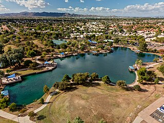
Mittry Lake is located in the Mittry Lake Wildlife Area, just north of Yuma, Arizona, on the Lower Colorado River. It is located in between the upstream Imperial Dam and the downstream Laguna Dam. Mittry Lake comprises about 750 acres (300 ha), with much of the shoreline covered with cattails and bullrush. The lake has undergone rehabilitation work including marsh dredging, revegetation and fish habitat improvement, making it a great location for small game hunting and sport fishing. It is public land managed by the Arizona Game and Fish Department, the Bureau of Reclamation and the Bureau of Land Management, and available to the public for recreational purposes.

The Salt River is a river in Gila and Maricopa counties in Arizona, United States, that is the largest tributary of the Gila River. The river is about 200 miles (320 km) long. Its drainage basin covers about 13,700 square miles (35,000 km2). The longest of the Salt River's many tributaries is the 195-mile (314 km) Verde River. The Salt's headwaters tributaries, the Black River and East Fork, increase the river's total length to about 300 miles (480 km). The name Salt River comes from the river's course over large salt deposits shortly after the merging of the White and Black Rivers.

The Verde River is a major tributary of the Salt River in the U.S. state of Arizona. It is about 170 miles (270 km) long and carries a mean flow of 602 cubic feet per second (17.0 m3/s) at its mouth. It is one of the largest perennial streams in Arizona.

Saguaro Lake is the fourth reservoir on the Salt River, formed by the Stewart Mountain Dam in the U.S. state of Arizona. The lake is off State Route 87, about halfway between Phoenix and the ghost town of Sunflower. The dammed end of the lake is at 33.5656°N 111.5361°W, at an elevation of 1,506 feet (459 m).

The yellow bullhead is a species of bullhead catfish, a ray-finned fish that lacks scales.
Show Low Lake is a 100-acre (0.40 km2) lake nestled at 6,500 feet (2,000 m) elevation in the White Mountains of Arizona which is administered by the Arizona Game and Fish Department along with the city of Show Low. Show Low Lake Park is located five miles (8 km) south of Show Low.

Alamo Lake State Park is a state park of Arizona, USA, centered on Alamo Lake, a flood control and recreational reservoir. The park is located in western Arizona about 38 miles (61 km) north of Wenden. It is accessed via a paved two-lane road off either U.S. Route 60 to the south or U.S. Route 93 to the east. Owing to its remoteness, the park is often considered one of the "best kept secrets" of the state park system.

Ictalurus pricei, the Yaqui catfish, is a species of North American freshwater catfish native to Mexico and Arizona.

Bartlett Lake is a reservoir that was formed by the damming of the Verde River in the U.S. state of Arizona. It is downstream and to the south of Horseshoe Reservoir. Constructed in 1936–39 by the Salt River Project, the Bartlett Dam and reservoir were named for Bill Bartlett, a government surveyor. Bartlett Lake was the first reservoir built on the Verde River.
Eagle Creek is a 58.5-mile-long (94.1 km) river located 50 miles (80 km) northwest of Clifton, Arizona, United States, at the base of the White Mountain Range. It is a tributary of the Gila River.

Parker Canyon Lake is located in southeastern Arizona, 28 miles (45 km) southwest of Sierra Vista around the Huachuca Mountains and about 5 miles (8.0 km) north of the border with Mexico. The lake is a reservoir formed by a dam in Parker Canyon in the south end of the Canelo Hills in southwestern Cochise County. Parker Canyon is a tributary to the Santa Cruz River in the San Rafael Valley. The facilities are maintained by Coronado National Forest division of the USDA Forest Service.

Patagonia Lake is a man-made reservoir in Santa Cruz County, Arizona, United States, located southwest of the town of Patagonia, Arizona and northeast of Nogales. The lake was created by damming Sonoita Creek, and is a popular area for boating and sport fishing. Facilities are maintained by Arizona State Parks as part of Patagonia Lake State Park.
Peña Blanca Lake is a reservoir in Arizona, United States, located 18 miles (29 km) northwest of Nogales. The facilities are maintained by the Coronado National Forest division of the USDA Forest Service. The lake was created in 1957 by the Arizona Game and Fish Department.Back then this lake was known for a plush resort that was located there. In 2008, the lake was closed to clean mercury contamination within the sediment, thought to be from old mines in the area. Also the former plush resort was removed as well. The lake was reopened in August 2009. In 2013, an Arizona Department of Environmental Quality report showed that mercury levels were similar to those before the lake was drained and dredged. One potential cause for the high mercury could be naturally occurring mercury seeping through the faults or a spring in the lake, though these claims are still under investigation.

Kiwanis Lake is located in Kiwanis Community Park in central Tempe, Arizona, United States, southwest of Baseline Road and Mill Avenue. The surrounding park's amenities include boating, group Ramadas, a playground, sports fields, a recreation center with a wave pool, and seasonal paddleboat rentals
Evelyn Hallman Pond, at Evelyn Hallman Park is a small man-made lake located west of Scottsdale Road and south of McKellips Road in the northern part of Tempe, Arizona. Lying on the east side of the Cross Cut Canal it must be reached from the east.
Desert Breeze Lake is located in Desert Breeze Park in west Chandler, Arizona, US, southwest of Ray Road and McClintock Drive on Desert Breeze Boulevard.
Alvord Lake is an urban fishing lake located in Cesar Chavez Park in Laveen, Arizona, at the southwest corner of 35th Avenue and Baseline Road.
Cortez Lake is located in Cortez Park in northwest Phoenix, Arizona, United States, at the northeast corner of 35th Avenue and Dunlap Avenue.
Red Mountain Lake is a small, man-made lake located in Red Mountain Park in Mesa, Arizona, United States, roughly between Power and Ellsworth Roads at Brown Road. It covers 8 acres and has a maximum depth of 17 feet.
The 2009 DARPA Network Challenge was a prize competition for exploring the roles the Internet and social networking play in the real-time communications, wide-area collaborations, and practical actions required to solve broad-scope, time-critical problems. The competition was sponsored by the Defense Advanced Research Projects Agency (DARPA), a research organization of the United States Department of Defense. The challenge was designed to help the military generate ideas for operating under a range of circumstances, such as natural disasters. Congress authorized DARPA to award cash prizes to further DARPA's mission to sponsor revolutionary, high-payoff research that bridges the gap between fundamental discoveries and their use for national security.


