
The Verde River is a major tributary of the Salt River in the U.S. state of Arizona. It is about 170 miles (270 km) long and carries a mean flow of 602 cubic feet per second (17.0 m3/s) at its mouth. It is one of the largest perennial streams in Arizona.

Saguaro Lake is the fourth reservoir on the Salt River, formed by the Stewart Mountain Dam in the U.S. state of Arizona. The lake is off State Route 87, about halfway between Phoenix and the ghost town of Sunflower. The dammed end of the lake is at 33.5656°N 111.5361°W, at an elevation of 1,506 feet (459 m).
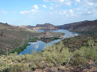
Canyon Lake is one of four reservoirs that were formed by the damming of the Salt River in the U.S. state of Arizona as part of the Salt River Project. It was formed by the Mormon Flat Dam, which was completed in 1925 after two years of construction. Canyon Lake, with a surface area of 950 acres (380 ha), is the third and smallest of the four lakes created along the river. Two others, Apache Lake and Roosevelt Lake, are upstream. The fourth, Saguaro Lake, is downstream.
Show Low Lake is a 100-acre (0.40 km2) lake nestled at 6,500 feet (2,000 m) elevation in the White Mountains of Arizona which is administered by the Arizona Game and Fish Department along with the city of Show Low. Show Low Lake Park is located five miles (8 km) south of Show Low.

Alamo Lake State Park is a state park of Arizona, USA, centered on Alamo Lake, a flood control and recreational reservoir. The park is located in western Arizona about 38 miles (61 km) north of Wenden. It is accessed via a paved two-lane road off either U.S. Route 60 to the south or U.S. Route 93 to the east. Owing to its remoteness, the park is often considered one of the "best kept secrets" of the state park system.
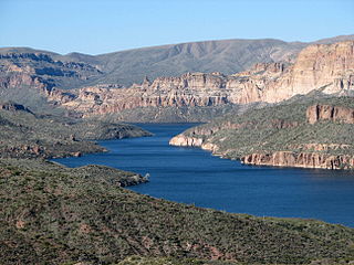
Apache Lake is one of four reservoirs built along the Salt River in central Arizona as part of the Salt River Project.

Lake Mary may refer to one of two reservoirs in northern Arizona southeast of Flagstaff. The name may also be used to refer to the two lakes as a whole. The pair of lakes impound the intermittent Walnut Creek upstream from Walnut Canyon. Recreational facilities at both lakes are maintained under the authority of the Coconino National Forest.
The Lyman Reservoir is the largest lake in the region. Lyman Lake State Park, is located in and administered by the Apache-Sitgreaves National Forest, attracts anglers, as well as campers and water skiers year-round.

Green Valley Lake is located in Payson, Arizona. Green Valley Lake is a reservoir connected to two smaller lakes in Green Valley Park. These lakes were constructed from 1993 to 1996 for ground water recharge.
Arivaca Lake is located in southern Arizona, 60 miles (97 km) south of Tucson near Arivaca, Arizona. In mid-1999, there was a total fish kill at this lake due to oxygen depletion. The facilities are maintained by the Arizona Game and Fish Department.
Eagle Creek is a 58.5-mile-long (94.1 km) river located 50 miles (80 km) northwest of Clifton, Arizona, United States, at the base of the White Mountain Range. It is a tributary of the Gila River.

Patagonia Lake is a man-made reservoir in Santa Cruz County, Arizona, United States, located southwest of the town of Patagonia, Arizona and northeast of Nogales. The lake was created by damming Sonoita Creek, and is a popular area for boating and sport fishing. Facilities are maintained by Arizona State Parks as part of Patagonia Lake State Park.

Roper Lake State Park is a state park of Arizona, surrounding 32-acre (130,000 m2) Roper Lake. The park is located off U.S. Route 191, 5 miles (8.0 km) south of Safford, at the Gila River and Valley.
Peña Blanca Lake is a reservoir in Arizona, United States, located 18 miles (29 km) northwest of Nogales. The facilities are maintained by the Coronado National Forest division of the USDA Forest Service. The lake was created in 1957 by the Arizona Game and Fish Department.Back then this lake was known for a plush resort that was located there. In 2008, the lake was closed to clean mercury contamination within the sediment, thought to be from old mines in the area. Also the former plush resort was removed as well. The lake was reopened in August 2009. In 2013, an Arizona Department of Environmental Quality report showed that mercury levels were similar to those before the lake was drained and dredged. One potential cause for the high mercury could be naturally occurring mercury seeping through the faults or a spring in the lake, though these claims are still under investigation.

Kennedy Lake is located in Tucson at J. F. Kennedy Park, north of Ajo Way between La Cholla Boulevard and Mission Road.

Sahuarita Lake is a human-made lake located 18 miles (29 km) south of downtown Tucson in Sahuarita, Arizona. The lake was created in 2000 and opened for public use in 2001.
Desert Breeze Lake is located in Desert Breeze Park in west Chandler, Arizona, US, southwest of Ray Road and McClintock Drive on Desert Breeze Boulevard.
Cortez Lake is located in Cortez Park in northwest Phoenix, Arizona, United States, at the northeast corner of 35th Avenue and Dunlap Avenue.

Fool Hollow Lake is a public lake located in Navajo County, Arizona, near the city of Show Low. The lake is operated by the Arizona State Parks Department, and consists of 150 acres (61 ha), with an average depth of 23 feet (7.0 m) together with a variety of fish species.
Surprise Lake is located in the City of Surprise, Arizona, United States, on the Surprise Recreation Campus in the north-west Valley, between Bell Road and Greenway on the east side of Bullard Avenue.
