
The Verde River is a major tributary of the Salt River in the U.S. state of Arizona. It is about 170 miles (270 km) long and carries a mean flow of 602 cubic feet per second (17.0 m3/s) at its mouth. It is one of the largest perennial streams in Arizona.

Saguaro Lake is the fourth reservoir on the Salt River, formed by the Stewart Mountain Dam in the U.S. state of Arizona. The lake is off State Route 87, about halfway between Phoenix and the ghost town of Sunflower. The dammed end of the lake is at 33.5656°N 111.5361°W, at an elevation of 1,506 feet (459 m).
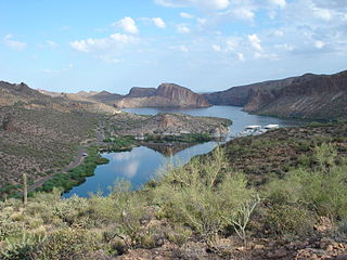
Canyon Lake is one of four reservoirs that were formed by the damming of the Salt River in the U.S. state of Arizona as part of the Salt River Project. It was formed by the Mormon Flat Dam, which was completed in 1925 after two years of construction. Canyon Lake, with a surface area of 950 acres (380 ha), is the third and smallest of the four lakes created along the river. Two others, Apache Lake and Roosevelt Lake, are upstream. The fourth, Saguaro Lake, is downstream.

Mormon Lake is a shallow, intermittent lake located in northern Arizona in Pleasant Valley. With an average depth of only 10 ft (3.0 m), the surface area of the lake is extremely volatile and fluctuates seasonally. When full, the lake has a surface area of about 12 square miles (31 km2), making it the largest natural lake in Arizona. In particularly dry times, the lake has been known to dry up, leaving behind a remnant marsh.
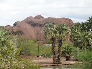
Papago Park is a municipal park of the cities of Phoenix and Tempe, Arizona, United States. It has been designated as a Phoenix Point of Pride. It includes Hunt's Tomb, which is listed on the National Register of Historic Places.
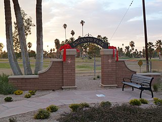
Encanto Park is a public park in central Phoenix, Arizona. The park is composed of 222 acres (0.90 km2) of land consisting of picnic areas, a lagoon, a boat house, swimming pool, nature trail, amusement park, fishing and two golf courses. The lagoon is approximately 7.5 acres (0.030 km2) in surface area and about 6 feet (1.8 m) deep, on average. The park is bounded by Thomas Road on the north, Encanto Boulevard on the south, 15th Avenue on the west and 7th Avenue on the east and is at a surface elevation of 1,100 ft (340 m).
Stoneman Lake is a small lake located in northern Arizona, about 30 mi (48 km) south of the city of Flagstaff. Like the nearby Mormon Lake, it is one of the few natural lakes in Arizona.
Chevelon Canyon Lake is a small reservoir located in northern Arizona, about 28 mi (45 km) northwest of the town of Heber. It is one in a series of small, canyon-bound lakes located on the Mogollon Rim, collectively referred to as the Rim Lakes. It is said to be among the most difficult to access in the region. It is also the second reservoir on Chevelon Creek, downstream from Woods Canyon Lake. The facilities are maintained by Apache–Sitgreaves National Forests division of the USDA Forest Service.

Ashurst Lake is a small lake located on the Anderson Mesa 20 miles (32 km) southeast of Flagstaff. It is one of the few natural lakes in the state of Arizona, the bulk of which reside in the area.
Canyon Creek is located in the Mogollon Rim area of the state of Arizona. The closest town, Young, is 20 miles (32 km) away. The facilities are maintained by Tonto National Forest division of the USDA Forest Service.

Tonto Creek is a 72.5-mile-long (116.7 km) stream located in the Mogollon Rim area of the state of Arizona on the north edge of the Tonto National Forest. The closest town, Payson, is 18 miles (29 km) away. Tonto Creek is a stream that flows year round, starting just below the Mogollon Rim, at the northern edge of Tonto National Forest. The creek continues its descent through the Hellsgate Wilderness area and eventually into a wide valley in the Sonoran Desert. It continues through the desert and into the Salt River within the north end of Theodore Roosevelt Lake. The facilities are maintained by Tonto National Forest division of the USDA Forest Service.
Arivaca Lake is located in southern Arizona, 60 miles (97 km) south of Tucson near Arivaca, Arizona. In mid-1999, there was a total fish kill at this lake due to oxygen depletion. The facilities are maintained by the Arizona Game and Fish Department.
Eagle Creek is a 58.5-mile-long (94.1 km) river located 50 miles (80 km) northwest of Clifton, Arizona, United States, at the base of the White Mountain Range. It is a tributary of the Gila River.

Patagonia Lake is a man-made reservoir in Santa Cruz County, Arizona, United States, located southwest of the town of Patagonia, Arizona and northeast of Nogales. The lake was created by damming Sonoita Creek, and is a popular area for boating and sport fishing. Facilities are maintained by Arizona State Parks as part of Patagonia Lake State Park.
Peña Blanca Lake is a reservoir in Arizona, United States, located 18 miles (29 km) northwest of Nogales. The facilities are maintained by the Coronado National Forest division of the USDA Forest Service. The lake was created in 1957 by the Arizona Game and Fish Department.Back then this lake was known for a plush resort that was located there. In 2008, the lake was closed to clean mercury contamination within the sediment, thought to be from old mines in the area. Also the former plush resort was removed as well. The lake was reopened in August 2009. In 2013, an Arizona Department of Environmental Quality report showed that mercury levels were similar to those before the lake was drained and dredged. One potential cause for the high mercury could be naturally occurring mercury seeping through the faults or a spring in the lake, though these claims are still under investigation.

Sahuarita Lake is a human-made lake located 18 miles (29 km) south of downtown Tucson in Sahuarita, Arizona. The lake was created in 2000 and opened for public use in 2001.
Kiwanis Lake is located in Kiwanis Community Park in central Tempe, Arizona, United States, southwest of Baseline Road and Mill Avenue.
Alvord Lake is an urban fishing lake located in Cesar Chavez Park in Laveen, Arizona, at the southwest corner of 35th Avenue and Baseline Road.
Cortez Lake is located in Cortez Park in northwest Phoenix, Arizona, United States, at the northeast corner of 35th Avenue and Dunlap Avenue.
