
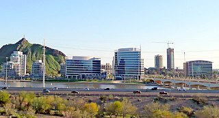
Phoenix is the capital and most populous city of the U.S. state of Arizona, with 1,608,139 residents as of 2020. It is the fifth-most populous city in the United States, and one of only two U.S. state capitals with a population of more than one million residents, along with Austin, Texas.
Tempe is a city in Maricopa County, Arizona, United States, with the Census Bureau reporting a 2020 population of 180,587. The city is named after the Vale of Tempe in Greece. Tempe is located in the East Valley section of metropolitan Phoenix; it is bordered by Phoenix and Guadalupe on the west, Scottsdale and the Salt River Pima–Maricopa Indian Community on the north, Chandler on the south, and Mesa on the east. Tempe is also the location of the main campus of Arizona State University.

The Southwestern United States, also known as the American Southwest or simply the Southwest, is a geographic and cultural region of the United States that generally includes Arizona, New Mexico, and adjacent portions of California, Colorado, Nevada, Oklahoma, Texas, and Utah. The largest cities by metropolitan area are Phoenix, Las Vegas, El Paso, Albuquerque, and Tucson. Prior to 1848, in the historical region of Santa Fe de Nuevo México as well as parts of Alta California and Coahuila y Tejas, settlement was almost non-existent outside of Nuevo México's Pueblos and Spanish or Mexican municipalities. Much of the area had been a part of New Spain and Mexico until the United States acquired the area through the Treaty of Guadalupe Hidalgo in 1848 and the smaller Gadsden Purchase in 1854.

The Gila River is a 649-mile (1,044 km)-long tributary of the Colorado River flowing through New Mexico and Arizona in the United States. The river drains an arid watershed of nearly 60,000 square miles (160,000 km2) that lies mainly within the U.S., but also extends into northern Sonora, Mexico.

Desert Diamond Arena is a multi-purpose entertainment arena located in Glendale, Arizona. The venue anchors the 223-acre, $1 billion Westgate Entertainment District.
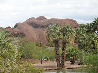
Papago Park is a municipal park of the cities of Phoenix and Tempe, Arizona, United States. It has been designated as a Phoenix Point of Pride. It includes Hunt's Tomb, which is listed on the National Register of Historic Places.

The following is an alphabetical list of articles related to the U.S. state of Arizona.
Deer Valley Unified School District #97 (DVUSD) is a Pre-K–12 school district, headquartered in Phoenix, Arizona, United States. DVUSD is the fifth largest school district in the state of Arizona, serving areas of Phoenix, Glendale, Peoria, Anthem, New River and numerous unincorporated areas of northwest Maricopa County. Situated within the Sonoran Desert, the District has grown from its modest beginnings as a county accommodation school located in New River in 1934 to 37 campuses serving 36,261 students: 15 K–6 elementary schools, 13 K–8 schools, three middle schools, and five comprehensive high schools, plus an online school and an alternative school. Early childhood education opportunities are offered through DVUSD Community Education Preschool/PreKindergarten, and Head Start. Twelve schools receive Title I funding. District facilities include District Office, Support Services Center, Transportation and Administrative Services.

Arizona State Route 74 (SR 74), locally known as the Carefree Highway, is a state highway in central Arizona that stretches east to west from its junction with U.S. Route 60 (US 60) just south of Wickenburg to its junction with Interstate 17 (I-17) in North Phoenix. It serves Lake Pleasant Regional Park and serves as a northern bypass around the often congested stretches of US 60 through the northwest suburbs of the Phoenix metropolitan area. From end to end, it is 30.4 miles (48.9 km) long.

Meadview is an unincorporated community and census-designated place (CDP) in Mohave County, Arizona, United States, located near Lake Mead. As of the 2020 census, Meadview had 1,420 residents, up from 1,224 as of 2010. It was founded in the 1960s as a retirement community and is still largely one, as well as a vacation spot for people coming to enjoy Lake Mead.

The Glendale Desert Dogs are a baseball team that plays in the West Division of the Arizona Fall League. They play their home games at Camelback Ranch in Glendale, Arizona. The ballpark is also the spring training facility of the Chicago White Sox and Los Angeles Dodgers. The team was established in 1992 as the Chandler Diamondbacks, and played for three seasons under that name. The team's nickname has been Desert Dogs since 1995, persisting through several location changes. The Desert Dogs have won six league championships, most recently in 2008. Their five consecutive championships from 2004 to 2008 are an Arizona Fall League record.
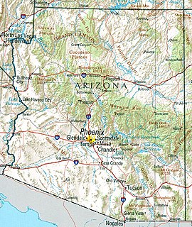
Arizona is a landlocked state situated in the southwestern region of the United States of America. It has a vast and diverse geography famous for its deep canyons, high- and low-elevation deserts, numerous natural rock formations, and volcanic mountain ranges. Arizona shares land borders with Utah to the north, the Mexican state of Sonora to the south, New Mexico to the east, and Nevada to the northwest, as well as water borders with California and the Mexican state of Baja California to the southwest along the Colorado River. Arizona is also one of the Four Corners states and is diagonally adjacent to Colorado.
Desert Breeze Lake is located in Desert Breeze Park in west Chandler, Arizona, US, southwest of Ray Road and McClintock Drive on Desert Breeze Boulevard.

Arizona is a state in the Southwestern United States. It is the 6th largest and the 14th most populous of the 50 states. Its capital and largest city is Phoenix. Arizona is part of the Four Corners region with Utah to the north, Colorado to the northeast, and New Mexico to the east; its other neighboring states are Nevada to the northwest, California to the west and the Mexican states of Sonora and Baja California to the south and southwest.
Many arterial roads in the Phoenix metropolitan area have the same name in multiple cities or towns. Some roads change names or route numbers across town borders, resulting in occasional confusion. For example, the road known as Apache Boulevard in Tempe continues east as Main Street in neighboring Mesa and then as Apache Trail in Apache Junction. Although Broadway Road maintains the same name through Goodyear, Avondale, Phoenix, Tempe, Mesa, and Apache Junction, each town uses a different reference point for address numbers.

The Sunnyslope community is an established neighborhood within the borders of the city of Phoenix, Arizona. The geographic boundaries are 19th Avenue to the west, Cactus Road to the north, 16th Street to the east, and Northern Avenue to the south. This area covers approximately nine square miles (23 km2) and is divided into nine census tracts. The Sunnyslope community is included in parts of three zip code areas: 85020, 85021 and 85029.
The Harcuvar Mountains are a narrow mountain range in western-central Arizona, United States. The range lies just east of the north-south Colorado River, and south of the east-west, west-flowing Bill Williams River, from Alamo Lake.
The Date Creek Mountains are a short, arid range in southwest Yavapai County, Arizona. Congress is on its southeast foothills, and Wickenburg lies 15 mi (24 km) southeast.

The Mountain states form one of the nine geographic divisions of the United States that are officially recognized by the United States Census Bureau. It is a subregion of the Western United States.
