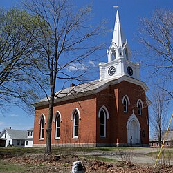
Claremont is the only city in Sullivan County, New Hampshire, United States. The population was 12,949 at the 2020 census.
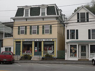
Wells River is a village in the town of Newbury in Orange County, Vermont, United States. The population was 431 at the 2020 census. The village center is located at the junction of U.S. Routes 5 and 302.

Charlestown is a town in Sullivan County, New Hampshire, United States. The population was 4,806 at the 2020 census, down from 5,114 at the 2010 census. The town is home to Hubbard State Forest and the headquarters of the Student Conservation Association.

The Old Middletown Post Office, in Middletown, Connecticut, also known as the U.S. Post Office, was built in 1916. It was listed on the National Register of Historic Places (NRHP) in 1982. The building is also on the NRHP as a contributing property of the Main Street Historic District.

The Williamsburg Center Historic District is a historic district on Massachusetts Route 9 in Williamsburg, Massachusetts. It encompasses the traditional center of the town, which was settled in the 18th century and grew to prosperity in the mid-19th century. It was listed on the National Register of Historic Places in 1980.

The Hatfield Center Historic District encompasses the traditional center of Hatfield, Massachusetts. The area, first laid out in 1661, is bounded by Maple Street to the south, the Connecticut River to the east, Day Avenue and School Street to the north, and the Mill River to the west. The area's layout and land use patterns are relatively little altered since they were laid out, leaving a well-preserved early colonial village landscape. The district was added to the National Register of Historic Places in 1994.
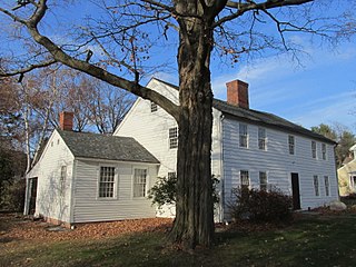
The Parsons, Shepherd, and Damon Houses Historic District is a historic district on the east side of downtown Northampton, Massachusetts encompassing a 2.5-acre (1.0 ha) property that was first laid out in 1654. Now owned by Historic Northampton, the property includes three houses built between 1730 and 1830. The district was added to the National Register of Historic Places in 2001.

Norwichtown is a historic neighborhood in the city of Norwich, Connecticut. It is generally the area immediately north of the Yantic River between I-395 and Route 169.

The Amherst Village Historic District encompasses the historic village center of Amherst, New Hampshire. Centered on the town's common, which was established about 1755, Amherst Village is one of the best examples of a late-18th to early-19th century New England village center. It is roughly bounded on the north by Foundry Street and on the south by Amherst Street, although it extends along some roads beyond both. The western boundary is roughly Davis Lane, the eastern is Mack Hill Road, Old Manchester Road, and Court House Road. The district includes the Congregational Church, built c. 1771-74, and is predominantly residential, with a large number of Georgian, Federal, and Greek Revival houses. Other notable non-residential buildings include the Farmer's Bank, a Federal-style brick building built in 1806, and the Amherst Brick School, a brick Greek Revival structure that now serves as a community center.

The Orford Street Historic District encompasses a particularly attractive stretch of Orford Street in Orford, New Hampshire. It was described as early as the 18th century as "the most charming country village", with a tree-lined promenade that is still a focus of the town center. The district consists of about 0.5 miles (0.80 km) of Orford Street, between its junctions with New Hampshire Route 25A and Archertown Road, and was listed on the National Register of Historic Places in 1977.

The Sawyer–Medlicott House is a historic house at the junction of Bradford and River roads in Piermont, New Hampshire. Built about 1820, it is a good example of Federal period architecture, and the only brick house of that style in the small town. It was built for Joseph Sawyer, a real estate speculator and politician. The house was listed on the National Register of Historic Places in 1991.

The Acworth Silsby Library is the public library of Acworth, New Hampshire, located in the town center at 5 Lynn Hill Road. Built in 1891 and funded by Acworth native Ithiel Homer Silsby, the building is a distinctive local example of Romanesque architecture. The building was listed on the National Register of Historic Places in 1983.

The Oliver Whiting Homestead is a historic farmstead on Old County Farm Road in Wilton, New Hampshire, just south of the County Farm Bridge. The 72-acre (29 ha) property was one of the region's largest dairy farms in the early 19th century, and it was used as Hillsborough County's poor farm between 1867 and 1896. The main focus of the property is a large Federal-style brick house built c. 1800 by Oliver Whiting; it also has an 1846 Gothic Revival barn which predates the establishment of the poor farm. The property was listed on the National Register of Historic Places in 1982.

Charlestown Town Hall is the seat of municipal government of Charlestown, New Hampshire. It is located just off Main Street at 29 Summer Street. It was built in 1872-73, and is a design of Edward Dow, one of New Hampshire's leading architects of the period. The building was listed on the National Register of Historic Places in 1984, and is a contributing property to the Charlestown Main Street Historic District.

The Newport Downtown Historic District encompasses the 19th century heart of Newport, New Hampshire, the county seat of Sullivan County. The district includes the major commercial and civic buildings which line Main Street between Depot Street and the Sugar River. The district was listed on the National Register of Historic Places in 1985.

The North Charlestown Historic District encompasses a 19th-century rural village in Charlestown, New Hampshire. Located about 5 miles (8 km) north of the town's center, the district includes a small cluster of buildings along New Hampshire Route 12A that is a remnant portion of a larger agricultural village. First settled in the 1750s, the oldest buildings in the district date to the 1790s, and most of the major buildings were built in the 19th century. Its economy was based on lumber and farming. The village was once considered a much larger, dispersed settlement, but construction of New Hampshire Route 11 in the 1960s separated some of the more remote parts of the village from its nucleus, which was bypassed by that construction.

The Town Center Historic District encompasses the historic village center of South Hampton, New Hampshire. Centered around the Barnard Green, the town common, on New Hampshire Route 107A, it includes architectural reminders of the town's growth and change over time. The district was listed on the National Register of Historic Places in 1983.
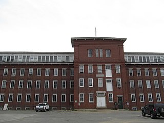
The Salmon Falls Mill Historic District encompasses a historic mill complex on Front Street in Rollinsford, New Hampshire. The complex includes four major structures and seven smaller ones, on about 14 acres (5.7 ha) of land along the Salmon Falls River. They were built between about 1840 and the mid-1860s, and have an unusual architectural unity, for additions made to the buildings were done with attention to matching design elements from the existing structures. The Number 2 Mill, built in 1848, was an early location where a turbine was used instead of a waterwheel to provide power to the mill machinery. The district was listed on the National Register of Historic Places in 1980.
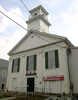
The Putney Village Historic District encompasses most of the main village and town center of Putney, Vermont. Settled in the 1760s, the village saw its major growth in the late 18th and early 19th century, and includes a cohesive collection with Federal and Greek Revival buildings, with a more modest number of important later additions, including the Italianate town hall. The district was listed on the National Register of Historic Places in 1986.

The Asbury Historic District is a 288 acres (117 ha) historic district encompassing the community of Asbury in Franklin Township of Warren County, New Jersey. It is bounded by County Route 632, County Route 643, Maple Avenue, Kitchen Road, and School Street and extends along the Musconetcong River into Bethlehem Township of Hunterdon County. It was listed on the National Register of Historic Places on March 19, 1993 for its significance in architecture, industry, religion, community development, politics/government, and commerce. The district includes 141 contributing buildings, a contributing structure, two contributing sites, and four contributing objects.
