Claremont is the only city in Sullivan County, New Hampshire, United States. The population was 12,949 at the 2020 census.

X̱á:ytem is an indigenous archaeological site and the name of a related museum run under the auspices of the Stoːlo people at Hatzic, British Columbia, Canada. X̱á:ytem is approximately 80 kilometres east of Vancouver on Highway 7. It is reached via the bridge at Mission, about 15 kilometres from the border with the US state of Washington. The site was designated in 1992 as a national historic site of Canada for its spiritual value to the Stoːlo people, as well as being one of the oldest discovered habitation sites at approximately 5000 years old. It was listed on the Canadian register of historic places in 2005. It is also known as Hatzic Rock National Historic Site of Canada.

The Kincaid Mounds Historic Site c. 1050–1400 CE, is a Mississippian culture archaeological site located at the southern tip of present-day U.S. state of Illinois, along the Ohio River. Kincaid Mounds has been notable for both its significant role in native North American prehistory and for the central role the site has played in the development of modern archaeological techniques. The site had at least 11 substructure platform mounds, and 8 other monuments.

The Modoc Rock Shelter is a rock shelter or overhang located beneath the sandstone bluffs that form the eastern border of the Mississippi River floodplain at which Native American peoples lived for thousands of years. This site is significant for its archaeological evidence of thousands of years of human habitation during the Archaic period in the Eastern United States. It is located on the northeastern side of County Road 7 southeast of Prairie du Rocher in Randolph County, Illinois, United States. It was declared a National Historic Landmark in 1961.

The Abbott Farm Historic District is a National Historic Landmark archaeological site in New Jersey. It is the largest known Middle Woodland village of its type on the East Coast of the United States. Significant evidence suggests that the Delaware River floodplain was occupied by Paleoindian people for a long period. It was inhabited between 500 BC and 500 AD. It has been a source of controversy and debate around early development.
The Schultz site, also known as Mira Creek site, and designated by archaeologists with the Smithsonian trinomial 25 VY 1, is a major prehistoric archaeological site near North Loup, Nebraska. It is the largest Middle Woodland period site in the state, covering 30,000 square feet (2,800 m2), with layers suggestive of repeated occupation. It is one of the oldest sites in the state exhibiting evidence of pottery manufacture. It was declared a National Historic Landmark in 1964.

The archaeology of Iowa is the study of the buried remains of human culture within the U.S. state of Iowa from the earliest prehistoric through the late historic periods. When the American Indians first arrived in what is now Iowa more than 13,000 years ago, they were hunters and gatherers living in a Pleistocene glacial landscape. By the time European explorers visited Iowa, American Indians were largely settled farmers with complex economic, social, and political systems. This transformation happened gradually. During the Archaic period American Indians adapted to local environments and ecosystems, slowly becoming more sedentary as populations increased. More than 3,000 years ago, during the Late Archaic period, American Indians in Iowa began utilizing domesticated plants. The subsequent Woodland period saw an increase on the reliance on agriculture and social complexity, with increased use of mounds, ceramics, and specialized subsistence. During the Late Prehistoric period increased use of maize and social changes led to social flourishing and nucleated settlements. The arrival of European trade goods and diseases in the Protohistoric period led to dramatic population shifts and economic and social upheaval, with the arrival of new tribes and early European explorers and traders. During the Historical period European traders and American Indians in Iowa gave way to American settlers and Iowa was transformed into an agricultural state.

Cedar Swamp Archeological District is a prehistoric and historic archaeologically sensitive area in eastern Westborough, Massachusetts, and extending into the northwest corner of Hopkinton. Cedar Swamp is an area of more than 2,600 acres (1,100 ha) of wetlands that include the headwaters area of the Sudbury River. Archeological surveys of the environmentally sensitive and critical area have identified many Native American sites of interest. It is believed that Native Americans prized wood from the cedar trees that grew in the area. The archeological district, which encompasses much of the Cedar Swamp area, was added to the National Register of Historic Places in 1988.
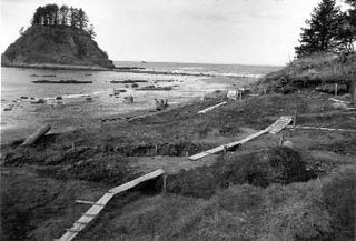
The Ozette Native American Village Archeological Site is the site of an archaeological excavation on the Olympic Peninsula near Neah Bay, Washington, United States. The site was a village occupied by the Ozette Makah people until a mudslide inundated the site around the year 1750. It is located in the now unpopulated Ozette Native American Reservation.

The Canfield Island Site, also known as Archeological Site 36LY37, is an archaeological site in Lycoming County, Pennsylvania, United States. Located on Canfield Island in the West Branch Susquehanna River, the site lies east of the city of Williamsport in Loyalsock Township. It is believed to have been inhabited by prehistoric Native Americans for thousands of years, with the oldest discoveries dating back to more than one millennium before Christ.
The Trinchera Cave Archeological District (5LA9555) is an archaeological site in Las Animas County, Colorado with artifacts primarily dating from 1000 BC to AD 1749, although there were some Archaic period artifacts found. The site was added to the National Register of Historic Places in 2001 and is located on State Trust Lands.
Archeological Site No. 1WI50 is an archaeological site in the Sipsey Wilderness of the William B. Bankhead National Forest in Winston County, Alabama. It was added to the National Register of Historic Places on December 14, 1985.

The Quinebaug River Prehistoric Archeological District encompasses a collection of prehistoric archaeological sites near the Quinebaug River in Canterbury, Connecticut. The district covers 22 acres (8.9 ha), including five sites dating from the Late Archaic to the period of European contact. The district was listed on the National Register of Historic Places in 2009, and was designated a state archaeological preserve in 2003.
The Baum Site (31Ck9) is one of the most prominent Middle and Late Woodland Period sites of the Colington Phase in the state of North Carolina. It is located north of Poplar Branch in Currituck County, North Carolina. This phase, marked by cultures of the Algonkian peoples, aligns with the Late Woodland period in North Carolina, occurring during English explorations between 1584 and 1587, and permanent settlement at 1650. This village is what the first English explorers encountered when entering the coastal region. The site contained ossuaries and evidence for a coastal village adaptation. The site was registered with the National Register of Historic Places on December 8, 1982, after testing and excavations in 1972 and 1973 by David Sutton Phelps, who was an archaeologist at East Carolina University. The site is suffering from erosion due to wave action. After the initial discovery, which was the result of erosion uncovering of remains, Phelps claimed, “this will provide the first glimpse of a coastal village of this type in the state”. A residential subdivision, Currituck Crossing, is now located on the Baum site. https://web.archive.org/web/20160617035403/http://co.currituck.nc.us/pdf/board-of-commissioners-minutes-2013/boc-minutes-13nov04.pdf.

The Platte River Campground Site, designated 20BZ16, is an archaeological site located along the Platte River, within the Sleeping Bear Dunes National Lakeshore near Empire, Michigan. It is significant as a largely intact record of prehistoric life over a long span of time. It was listed on the National Register of Historic Places in 1990.

The Martin Site (44WY13) is a prehistoric Native American village site in Wythe County, Virginia, United States. It is located on the banks of the New River near the community of Fosters Falls. The site has clear evidence of occupation during the Late Woodland period, and offers evidence of older occupation. Finds at the site include pottery sherds, stone tools, ceramic and shell trade items, and grave sites.

Aquadoctan was one of the largest known Native American villages in what is now the U.S. state of New Hampshire. In an area commonly known today as The Weirs, the village lay on the north bank of the Winnipesaukee River at the outlet of Lake Winnipesaukee in the Lakes Region of New Hampshire. The site is now in Weirs Beach, a summer resort and village of the city of Laconia. The Native American village, whose archaeological remains extend for a half mile along the river and a quarter mile along the lake, has been documented through archaeological investigation to have evidence of settlement from 9,000 BCE to the late seventeenth century. Colonial reports document that the site was abandoned substantially in 1696, when most of New Hampshire's remaining native population withdrew to join the Pequawket at present-day Fryeburg, Maine.

The Lochmere Archeological District is a large archeological area on the banks of the Winnipesaukee River in Belknap County, New Hampshire, near the village of Lochmere. The area, part of which is now preserved by the state as the Brennick Lochmere Archaeological Site, is a multi-component site with evidence of human occupation from the Middle Archaic through the Late Woodland periods. The site was occupied in historic times by the Winnipesaukee sub-tribe of the Pennacook people, and is near Aquadoctan, one of the largest native towns of prehistoric New Hampshire.
The Winooski Archeological Site, designated VT-CH-46 by state archaeologists, is a prehistoric Native American site in the city of Winooski, Vermont. First identified in 1972, it is one of the largest Native encampment sites of the Middle Woodland period in the northeastern United States. It was listed on the National Register of Historic Places in 1978, at which time it was recognized as one of just two stratified Woodland period sites in the state.

The Moccasin Bluff site is an archaeological site located along the Red Bud Trail and the St. Joseph River north of Buchanan, Michigan. It was listed on the National Register of Historic Places in 1977, and has been classified as a multi-component prehistoric site with the major component dating to the Late Woodland/Upper Mississippian period.