Chemical equator

Last updated
NASA imaging of a pollution filled "brown storm cloud" over Southeast Asia. Giant Brown Cloud Storm over Asia (NASA).jpg
NASA imaging of a pollution filled "brown storm cloud" over Southeast Asia.

The chemical equator term and concept was coined in 2008 when researchers from University of York discovered a distinct divide between the polluted air and haze over Indonesia from the largely uncontaminated atmosphere over Australia. This divide is distinguishable by a rapid increase in atmospheric levels of carbon monoxide and other pollutants from the Tropical Warm Pool region northward. [1] The divide of the atmosphere of the northern hemisphere from the atmosphere of the southern hemisphere is different from that of the Intertropical Convergence Zone. [2]

Contents

Discovery

Scientists at the University of York's Department of Chemistry conducted the first research that supported the concept of a 50 km wide chemical equator by comparing concentrations of atmospheric pollutants in both sides. [2] They observed that the atmospheric boundary, where drastic and quick changes in pollutants occurred, was well north of the Intertropical Convergence Zone, which was previously thought to be the only chemical atmospheric boundary. This discovery is also the first observance of meteorological and chemical boundaries between air masses not being the same, though correlated. [1]

Causes

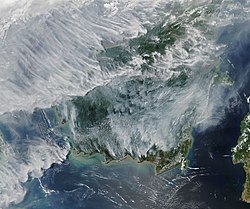
Biomass burning within this region, particularly from Southeast Asia, is responsible for the polluted air which is uplifted by convection and dispersed into the atmosphere over the Western Pacific. This convection is in contrast to the clean ocean air that is advected by cyclones over Northern Australia. [1] Greenhouse gases are produced at high rates in Southeast Asia due to the less developed burning conditions, large population, and fast population growth. The soluble pollutants are mostly removed during the summer by monsoons and winds but during winter these pollutants are more present in the atmosphere, making the divide more definite. [3]

Storm systems in the Tropical Warm Pool may also increase the influence of the atmospheric pollutants by acting as a pump that lifts polluted air higher up in the atmosphere where it will remain suspended for a longer period of time, as well as helping to spread it. [2]

See also

Related Research Articles

<span class="mw-page-title-main">Geography of Brunei</span>

Brunei is a country in Southeast Asia, bordering the South China Sea and East Malaysia. Its geographical coordinates are 4°30′N114°40′E. The country is small with a total size of 5,765 km2 (2,226 sq mi). It is larger in size than Trinidad and Tobago. It is close to vital sea lanes through the South China Sea linking the Indian and Pacific Oceans. The country has two parts physically separated by Malaysia, making it almost an enclave within Malaysia.

The Indian Ocean brown cloud or Asian brown cloud is a layer of air pollution that recurrently covers parts of South Asia, namely the northern Indian Ocean, India, and Pakistan. Viewed from satellite photos, the cloud appears as a giant brown stain hanging in the air over much of the Indian subcontinent and the Indian Ocean every year between October and February, possibly also during earlier and later months. The term was coined in reports from the UNEP Indian Ocean Experiment (INDOEX). It was found to originate mostly due to farmers burning stubble in Punjab and to lesser extent Haryana and Uttar Pradesh. The debilitating air quality in Delhi is also due to the stubble burning in Punjab.

<span class="mw-page-title-main">Horse latitudes</span> Latitudes 30–35 degrees north and south of the Equator

The horse latitudes are the latitudes about 30 degrees north and south of the Equator. They are characterized by sunny skies, calm winds, and very little precipitation. They are also known as subtropical ridges or highs. It is a high-pressure area at the divergence of trade winds and the westerlies.

<span class="mw-page-title-main">Water vapor</span> Gaseous phase of water

Water vapor, water vapour or aqueous vapor is the gaseous phase of water. It is one state of water within the hydrosphere. Water vapor can be produced from the evaporation or boiling of liquid water or from the sublimation of ice. Water vapor is transparent, like most constituents of the atmosphere. Under typical atmospheric conditions, water vapor is continuously generated by evaporation and removed by condensation. It is less dense than most of the other constituents of air and triggers convection currents that can lead to clouds and fog.

<span class="mw-page-title-main">Tropopause</span> The boundary of the atmosphere between the troposphere and stratosphere

The tropopause is the atmospheric boundary that demarcates the troposphere from the stratosphere, which are the lowest two of the five layers of the atmosphere of Earth. The tropopause is a thermodynamic gradient-stratification layer that marks the end of the troposphere, and is approximately 17 kilometres (11 mi) above the equatorial regions, and approximately 9 kilometres (5.6 mi) above the polar regions.

<span class="mw-page-title-main">Anticyclone</span> Weather phenomenon of high pressure, as opposed to a cyclone

An anticyclone is a weather phenomenon defined as a large-scale circulation of winds around a central region of high atmospheric pressure, clockwise in the Northern Hemisphere and counterclockwise in the Southern Hemisphere as viewed from above. Effects of surface-based anticyclones include clearing skies as well as cooler, drier air. Fog can also form overnight within a region of higher pressure.

<span class="mw-page-title-main">Intertropical Convergence Zone</span> Meteorological phenomenon

The Intertropical Convergence Zone, known by sailors as the doldrums or the calms because of its monotonous windless weather, is the area where the northeast and the southeast trade winds converge. It encircles Earth near the thermal equator though its specific position varies seasonally. When it lies near the geographic Equator, it is called the near-equatorial trough. Where the ITCZ is drawn into and merges with a monsoonal circulation, it is sometimes referred to as a monsoon trough.

<span class="mw-page-title-main">Atmospheric circulation</span> Process which distributes thermal energy about the Earths surface

Atmospheric circulation is the large-scale movement of air and together with ocean circulation is the means by which thermal energy is redistributed on the surface of the Earth. The Earth's atmospheric circulation varies from year to year, but the large-scale structure of its circulation remains fairly constant. The smaller-scale weather systems – mid-latitude depressions, or tropical convective cells – occur chaotically, and long-range weather predictions of those cannot be made beyond ten days in practice, or a month in theory.

<span class="mw-page-title-main">Low-pressure area</span> Area with air pressures lower than adjacent areas

In meteorology, a low-pressure area, low area or low is a region where the atmospheric pressure is lower than that of surrounding locations. Low-pressure areas are commonly associated with inclement weather, while high-pressure areas are associated with lighter winds and clear skies. Winds circle anti-clockwise around lows in the northern hemisphere, and clockwise in the southern hemisphere, due to opposing Coriolis forces. Low-pressure systems form under areas of wind divergence that occur in the upper levels of the atmosphere (aloft). The formation process of a low-pressure area is known as cyclogenesis. In meteorology, atmospheric divergence aloft occurs in two kinds of places:

<span class="mw-page-title-main">Trade winds</span> Equatorial east-to-west prevailing winds

The trade winds or easterlies are permanent east-to-west prevailing winds that flow in the Earth's equatorial region. The trade winds blow mainly from the northeast in the Northern Hemisphere and from the southeast in the Southern Hemisphere, strengthening during the winter and when the Arctic oscillation is in its warm phase. Trade winds have been used by captains of sailing ships to cross the world's oceans for centuries. They enabled European colonization of the Americas, and trade routes to become established across the Atlantic Ocean and the Pacific Ocean.

<span class="mw-page-title-main">Pressure system</span> Relative peak or lull in the sea level pressure distribution

A pressure system is a peak or lull in the sea level pressure distribution. The surface pressure at sea level varies minimally, with the lowest value measured 87 kilopascals (26 inHg) and the highest recorded 108.57 kilopascals (32.06 inHg). High- and low-pressure systems evolve due to interactions of temperature differentials in the atmosphere, temperature differences between the atmosphere and water within oceans and lakes, the influence of upper-level disturbances, as well as the amount of solar heating or radiationized cooling an area receives. Pressure systems cause weather to be experienced locally. Low-pressure systems are associated with clouds and precipitation that minimize temperature changes throughout the day, whereas high-pressure systems normally associate with dry weather and mostly clear skies with larger diurnal temperature changes due to greater radiation at night and greater sunshine during the day. Pressure systems are analyzed by those in the field of meteorology within surface weather maps.

In meteorology, the polar highs are areas of high atmospheric pressure, sometimes similar to anticyclones, around the North and South Poles; the south polar high being the stronger one because land gains and loses heat more effectively than sea, which the north has much less of. The cold temperatures in the polar regions cause air to descend, creating the high pressure, just as the warm temperatures around the equator cause air to rise instead and create the low pressure intertropical convergence zone. Rising air also occurs along bands of low pressure situated just below the polar highs around the 50th parallel of latitude. These extratropical convergence zones are occupied by the polar fronts where air masses of polar origin meet and clash with those of tropical or subtropical origin in a stationary front. This convergence of rising air completes the vertical cycle around the polar cell in each latitudinal hemisphere's polar region. Closely related to this concept is the polar vortex, a rotating low-pressure circle of cold air around the poles.

Rainfall and the tropical climate dominate the tropical rain belt, which oscillates from the northern to the southern tropics over the course of the year, roughly following the solar equator. The tropical rain belt is an area of active rain that is positioned mostly around the tropics.

This is a list of meteorology topics. The terms relate to meteorology, the interdisciplinary scientific study of the atmosphere that focuses on weather processes and forecasting.

<span class="mw-page-title-main">Mesoscale convective system</span> Complex of thunderstorms organized on a larger scale

A mesoscale convective system (MCS) is a complex of thunderstorms that becomes organized on a scale larger than the individual thunderstorms but smaller than extratropical cyclones, and normally persists for several hours or more. A mesoscale convective system's overall cloud and precipitation pattern may be round or linear in shape, and include weather systems such as tropical cyclones, squall lines, lake-effect snow events, polar lows, and mesoscale convective complexes (MCCs), and generally forms near weather fronts. The type that forms during the warm season over land has been noted across North and South America, Europe, and Asia, with a maximum in activity noted during the late afternoon and evening hours.

<span class="mw-page-title-main">Atmospheric dispersion modeling</span> Mathematical simulation of how air pollutants disperse in the ambient atmosphere

Atmospheric dispersion modeling is the mathematical simulation of how air pollutants disperse in the ambient atmosphere. It is performed with computer programs that include algorithms to solve the mathematical equations that govern the pollutant dispersion. The dispersion models are used to estimate the downwind ambient concentration of air pollutants or toxins emitted from sources such as industrial plants, vehicular traffic or accidental chemical releases. They can also be used to predict future concentrations under specific scenarios. Therefore, they are the dominant type of model used in air quality policy making. They are most useful for pollutants that are dispersed over large distances and that may react in the atmosphere. For pollutants that have a very high spatio-temporal variability and for epidemiological studies statistical land-use regression models are also used.

<span class="mw-page-title-main">Convergence zone</span> Region in the atmosphere

A convergence zone in meteorology is a region in the atmosphere where two prevailing flows meet and interact, usually resulting in distinctive weather conditions. This causes a mass accumulation that eventually leads to a vertical movement and to the formation of clouds and precipitation. Large-scale convergence, called synoptic-scale convergence, is associated with weather systems such as baroclinic troughs, low-pressure areas, and cyclones. The large-scale convergence zone formed over the equator, the Intertropical Convergence Zone, has condensed and intensified as a result of the global increase in temperature. Small-scale convergence will give phenomena from isolated cumulus clouds to large areas of thunderstorms.

<span class="mw-page-title-main">Monsoon trough</span> Weather phenomenon

The monsoon trough is a portion of the Intertropical Convergence Zone in the Western Pacific, as depicted by a line on a weather map showing the locations of minimum sea level pressure, and as such, is a convergence zone between the wind patterns of the southern and northern hemispheres.

<span class="mw-page-title-main">Tropical cyclogenesis</span> Development and strengthening of a tropical cyclone in the atmosphere

Tropical cyclogenesis is the development and strengthening of a tropical cyclone in the atmosphere. The mechanisms through which tropical cyclogenesis occurs are distinctly different from those through which temperate cyclogenesis occurs. Tropical cyclogenesis involves the development of a warm-core cyclone, due to significant convection in a favorable atmospheric environment.

There are a number of explanations of the asymmetry of the Intertropical Convergence Zone (ITCZ), known by sailors as the Doldrums.

References

  1. 1 2 3 Hamilton, Jacqueline F.; Allen, Grant; Watson, Nicola M.; Lee, James D.; Saxton, Julie E.; Lewis, Alastair C.; Vaughan, Geraint; Bower, Keith N.; Flynn, Michael J.; Crosier, Jonathan; Carver, Glenn D. (2008). "Observations of an atmospheric chemical equator and its implications for the tropical warm pool region" (PDF). Journal of Geophysical Research. 113 (D20): D20313. Bibcode:2008JGRD..11320313H. doi: 10.1029/2008JD009940 . ISSN   0148-0227.
  2. 1 2 3 University of York, 2008, 'Chemical Equator' Discovery Will Aid Pollution Mapping: Science Daily: https://www.sciencedaily.com/releases/2008/09/080923091339.htm (accessed November 2021).
  3. Lawrence, M. G.; Lelieveld, J. (2010). "Atmospheric pollutant outflow from southern Asia: a review". Atmospheric Chemistry and Physics. 10 (22): 11017–11096. Bibcode:2010ACP....1011017L. doi: 10.5194/acp-10-11017-2010 . ISSN   1680-7324.