Chester, Maryland

Last updated
Chester, Maryland
CDP
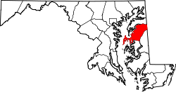
Queen Anne's County Maryland Incorporated and Unincorporated areas Chester Highlighted.svg
Coordinates: 38°58′19″N76°17′17″W / 38.97194°N 76.28806°W / 38.97194; -76.28806 Coordinates: 38°58′19″N76°17′17″W / 38.97194°N 76.28806°W / 38.97194; -76.28806
CountryUnited States
State Maryland
County Queen Anne's
Area
[1]
  Total6.98 sq mi (18.09 km2)
  Land5.24 sq mi (13.56 km2)
  Water1.75 sq mi (4.52 km2)
Elevation
7 ft (2 m)
Population
 (2020)
  Total5,003
  Density955.32/sq mi (368.84/km2)
Time zone UTC−5 (Eastern (EST))
  Summer (DST) UTC−4 (EDT)
ZIP code
21619
Area code 410
FIPS code 24-16125
GNIS feature ID0597229

Chester is a census-designated place on Kent Island in Queen Anne's County, Maryland, United States. The population was 3,723 at the 2000 census.

Contents

Geography

Chester is located at 38°58′19″N76°17′17″W / 38.97194°N 76.28806°W / 38.97194; -76.28806 (38.971907, 76.288045). [2]

According to the United States Census Bureau, the CDP has a total area of 7.0 square miles (18 km2), of which 5.3 square miles (14 km2) is land and 1.8 square miles (4.7 km2) (24.89%) is water.

Demographics

Historical population
CensusPop.
2020 5,003
U.S. Decennial Census [3]

As of the census [4] of 2000, there were 3,723 people, 1,567 households, and 1,037 families residing in the CDP. The population density was 705.3 inhabitants per square mile (272.3/km2). There were 1,723 housing units at an average density of 326.4 per square mile (126.0/km2). The racial makeup of the CDP was 89.61% White, 7.06% African American, 0.13% Native American, 1.02% Asian, 0.05% Pacific Islander, 0.59% from other races, and 1.53% from two or more races. Hispanic or Latino of any race were 1.32% of the population.

There were 1,567 households, out of which 28.1% had children under the age of 18 living with them, 50.4% were married couples living together, 11.8% had a female householder with no husband present, and 33.8% were non-families. 27.1% of all households were made up of individuals, and 10.2% had someone living alone who was 65 years of age or older. The average household size was 2.38 and the average family size was 2.87.

In the CDP, the population was spread out, with 23.1% under the age of 18, 6.6% from 18 to 24, 30.3% from 25 to 44, 26.0% from 45 to 64, and 14.0% who were 65 years of age or older. The median age was 39 years. For every 100 females, there were 94.3 males. For every 100 females age 18 and over, there were 90.8 males.

The median income for a household in the CDP was $56,558, and the median income for a family was $60,195. Males had a median income of $42,289 versus $30,495 for females. The per capita income for the CDP was $27,789. About 3.3% of families and 4.9% of the population were below the poverty line, including 7.5% of those under age 18 and 3.7% of those age 65 or over.

Notable person

Related Research Articles

<span class="mw-page-title-main">Bayview-Montalvin, California</span> Former CDP in California, United States

Bayview-Montalvin is a former census-designated place (CDP) in Contra Costa County, California, United States. The population was 5,004 at the 2000 census.

<span class="mw-page-title-main">North El Monte, California</span> Census-designated place in California, United States

North El Monte is a census-designated place (CDP) in the San Gabriel Valley, in Los Angeles County, California, United States. The population was 3,723 at the 2010 census, up from 3,703 at the 2000 census.

<span class="mw-page-title-main">South Apopka, Florida</span> Census-designated place in Florida, United States

South Apopka is a census-designated place and an unincorporated area in Orange County, Florida, United States. Per the 2020 census, the population was 6,803. It is part of the Orlando–Kissimmee Metropolitan Statistical Area.

<span class="mw-page-title-main">Selby-on-the-Bay, Maryland</span> Former census-designated place in Maryland, United States

Selby-on-the-Bay is a census-designated place (CDP) in Anne Arundel County, Maryland, United States, for the 2000 census, at which time its population was 3,674. It was added to the Mayo CDP for the 2010 census.

<span class="mw-page-title-main">Algonquin, Maryland</span> Census-designated place in Maryland, United States

Algonquin is a census-designated place (CDP) in Dorchester County, Maryland, United States. The population was 1,241 at the 2010 census. The community was named for the Algonquin people, one of the Native American tribes in the East.

<span class="mw-page-title-main">Kent Narrows, Maryland</span> CDP in Maryland, United States

Kent Narrows is a census-designated place and town in Queen Anne's County, Maryland, United States. As of the 2000 census, the town had a population of 567.

<span class="mw-page-title-main">Gray Summit, Missouri</span> Census-designated place in Missouri, United States

Gray Summit is an unincorporated community and census-designated place (CDP) in Franklin County, Missouri, United States. The population was 2,701 at the 2010 census. Also called "Gray's Summit", it was founded by Daniel Gray of New York, who built a hotel here in 1845. It is located on Missouri Route 100 just north of Interstate 44.

<span class="mw-page-title-main">Horine, Missouri</span> Census-designated place in Missouri, United States

Horine is an unincorporated community and census-designated place (CDP) in Jefferson County, Missouri, United States. The population was 821 at the 2010 census, down from 923 in 2000.

<span class="mw-page-title-main">Inverness, Montana</span> CDP in Montana, United States

Inverness is a census-designated place (CDP) in Hill County, Montana, United States. The population was 55 at the 2010 census. It was named after a town in Scotland.

<span class="mw-page-title-main">Joplin, Montana</span> Unincorporated community in Montana, United States

Joplin is a unincorporated community and census-designated place (CDP) in Liberty County, Montana, United States. The population was 157 at the 2010 census.

<span class="mw-page-title-main">Tajique, New Mexico</span> CDP in New Mexico, United States

Tajique is a census-designated place (CDP) in Torrance County, New Mexico, United States. The population was 148 at the 2000 census. It is part of the Albuquerque Metropolitan Statistical Area.

<span class="mw-page-title-main">Olde West Chester, Ohio</span> Census-designated place in Ohio, United States

Olde West Chester is a census-designated place (CDP) in West Chester Township, Butler County, Ohio, United States. The population was 240 at the 2010 census.

West Goshen was a census-designated place (CDP) in West Goshen Township, Chester County, Pennsylvania, United States. The population was 8,472 at the 2000 census. The CDP was not delineated for the 2010 census.

<span class="mw-page-title-main">Village Green-Green Ridge, Pennsylvania</span> Census-designated place in Pennsylvania, United States

Village Green-Green Ridge is a census-designated place (CDP) in Delaware County, Pennsylvania, United States. The population was 7,822 at the 2010 census, down from 8,279 at the 2000 census.

<span class="mw-page-title-main">Edgewood, Northumberland County, Pennsylvania</span> CDP in Pennsylvania, United States

Edgewood is a census-designated place (CDP) located in Coal Township, in Northumberland County, Pennsylvania, United States. The population was 2,619 at the 2000 census.

<span class="mw-page-title-main">Buck Run, Pennsylvania</span> CDP in Pennsylvania, United States

Buck Run is a census-designated place (CDP) in Schuylkill County, Pennsylvania, United States. The population was 176 at the 2010 census.

<span class="mw-page-title-main">Valley View, Schuylkill County, Pennsylvania</span> CDP in Pennsylvania, United States

Valley View is a census-designated place (CDP) in Schuylkill County, Pennsylvania, United States. The population was 1,677 at the 2000 census.

<span class="mw-page-title-main">Pennville, Pennsylvania</span> CDP in Pennsylvania, United States

Pennville is a census-designated place (CDP) in York County, Pennsylvania, United States. The population was 1,947 at the 2010 census.

<span class="mw-page-title-main">Gayle Mill, South Carolina</span> Census-designated place in South Carolina, United States

Gayle Mill is a census-designated place (CDP) in Chester County, South Carolina, United States. The population was 913 at the 2010 census, down from 1,094 at the 2000 census.

<span class="mw-page-title-main">Cokesbury, South Carolina</span> Census-designated place in South Carolina, United States

Cokesbury is a census-designated place (CDP) in Greenwood County, South Carolina, United States. The population was 215 at the 2010 census, down from 279 in 2000.

References

  1. "2020 U.S. Gazetteer Files". United States Census Bureau. Retrieved April 26, 2022.
  2. "US Gazetteer files: 2010, 2000, and 1990". United States Census Bureau. 2011-02-12. Retrieved 2011-04-23.
  3. "Census of Population and Housing". Census.gov. Retrieved June 4, 2016.
  4. "U.S. Census website". United States Census Bureau . Retrieved 2008-01-31.