Kent Narrows, Maryland

Last updated

Kent Narrows, Maryland
CDP
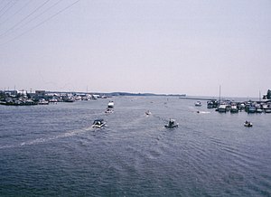
Chesapeake Country Scenic Byway - Overlook of Kent Narrows Channel - NARA - 7717626.jpg
Boaters enjoy a sunny Sunday afternoon on the Kent Narrows Channel
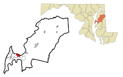
Queen Anne's County Maryland Incorporated and Unincorporated areas Kent Narrows Highlighted.svg
Coordinates: 38°58′9″N76°14′25″W / 38.96917°N 76.24028°W / 38.96917; -76.24028
CountryUnited States
State Maryland
County Queen Anne's
Area
[1]
  Total3.22 sq mi (8.33 km2)
  Land0.94 sq mi (2.44 km2)
  Water2.28 sq mi (5.90 km2)
Elevation
7 ft (2 m)
Population
 (2020)
  Total612
  Density650.37/sq mi (251.05/km2)
Time zone UTC−5 (Eastern (EST))
  Summer (DST) UTC−4 (EDT)
FIPS code 24-43725
GNIS feature ID1852595

Kent Narrows is a census-designated place and town in Queen Anne's County, Maryland, United States. As of the 2020 census [2] , the town had a population of 612.

Contents

Geography

Kent Narrows is located at 38°58′09″N76°14′25″W / 38.969259°N 76.240177°W / 38.969259; -76.240177 . [3]

According to the United States Census Bureau, the CDP has a total area of 2.6 square miles (6.7 km2), of which 1.0 square mile (2.6 km2) is land and 1.6 square miles (4.1 km2) (62.16%) is water.

Demographics

Historical population
CensusPop.Note
2020 612
U.S. Decennial Census [4]

As of the census [5] of 2000, there were 567 people, 277 households, and 188 families residing in the CDP. The population density was 576.8 inhabitants per square mile (222.7/km2). There were 358 housing units at an average density of 364.2 per square mile (140.6/km2). The racial makeup of the CDP was 96.30% White, 2.82% African American, 0.18% Asian, and 0.71% from two or more races. Hispanic or Latino of any race were 1.23% of the population.

There were 277 households, out of which 10.8% had children under the age of 18 living with them, 65.3% were married couples living together, 1.8% had a female householder with no husband present, and 31.8% were non-families. 24.9% of all households were made up of individuals, and 7.6% had someone living alone who was 65 years of age or older. The average household size was 2.05 and the average family size was 2.38.

In the CDP, the population was spread out, with 9.7% under the age of 18, 2.8% from 18 to 24, 19.2% from 25 to 44, 47.8% from 45 to 64, and 20.5% who were 65 years of age or older. The median age was 53 years. For every 100 females, there were 96.2 males. For every 100 females age 18 and over, there were 92.5 males.

The median income for a household in the CDP was $95,239, and the median income for a family was $99,467. Males had a median income of $83,471 versus $42,813 for females. The per capita income for the CDP was $48,899. None of the families and 4.8% of the population were living below the poverty line, including no under eighteens and 3.3% of those over 64.

Related Research Articles

<span class="mw-page-title-main">Valencia West, Arizona</span> CDP in Pima County, Arizona

Valencia West is a census-designated place (CDP) in Pima County, Arizona, United States. The population was 9,355 at the 2010 census, a 293% increase over the population of 2,380 in 2000.

<span class="mw-page-title-main">Bayview-Montalvin, California</span> Former CDP in California, United States

Bayview-Montalvin is a former census-designated place (CDP) in Contra Costa County, California, United States. The population was 5,004 at the 2000 census.

<span class="mw-page-title-main">Hillsmere Shores, Maryland</span> Former census-designated place in Maryland, United States

Hillsmere Shores was a census-designated place (CDP) in Anne Arundel County, Maryland, United States. It is a suburb of Annapolis. The population was 2,977 at the 2000 census. It was included in the Annapolis Neck CDP at the 2010 census. Built in phases, beginning in 1960, the community has been home to The Key School, a non-sectarian private school, since the 1960s.

<span class="mw-page-title-main">Riva, Maryland</span> Census-designated place in Maryland, United States

Riva is a census-designated place (CDP) in Anne Arundel County, Maryland, United States. The population was 4,257 at the 2020 census. The area is scenic, especially where the two-lane Riva Road crosses the South River on a bridge. The area is growing with large new homes as the suburbs of Annapolis grow outward. Riva is bordered by Annapolis to the north, Edgewater to the east, and Davidsonville to the west.

<span class="mw-page-title-main">Selby-on-the-Bay, Maryland</span> Former census-designated place in Maryland, United States

Selby-on-the-Bay is a census-designated place (CDP) in Anne Arundel County, Maryland, United States, for the 2000 census, at which time its population was 3,674. It was added to the Mayo CDP for the 2010 census.

<span class="mw-page-title-main">Algonquin, Maryland</span> Census-designated place in Maryland, United States

Algonquin is a census-designated place (CDP) in Dorchester County, Maryland, United States. The population was 1,241 at the 2010 census. The community was named for the Algonquin people, one of the Native American tribes in the East.

<span class="mw-page-title-main">Chester, Maryland</span> CDP in Maryland, United States

Chester is a census-designated place on Kent Island in Queen Anne's County, Maryland, United States. The population was 3,723 at the 2000 census.

<span class="mw-page-title-main">Seneca Knolls, New York</span> Census-designated place in New York, United States

Seneca Knolls is a hamlet in Onondaga County, New York, United States. The population was 2,011 at the 2010 census.

<span class="mw-page-title-main">Village Green, New York</span> Census-designated place in New York, United States

Village Green is a hamlet in Onondaga County, New York, United States. The population was 3,891 at the 2010 census.

<span class="mw-page-title-main">Kenwood, Ohio</span> Census-designated place in Ohio, United States

Kenwood is a census-designated place (CDP) in Sycamore Township, Hamilton County, Ohio, United States. The population was 7,570 at the 2020 census. It is a major shopping destination for the Cincinnati area, featuring properties such as Kenwood Towne Centre and The Kenwood Collection.

Jacksonville is a census-designated place (CDP) in Indiana County, Pennsylvania, United States. The population was 637 at the 2010 census. It was formerly an independent borough, until January 1, 1993 when it was returned to Black Lick Township, Pennsylvania.

Arlington Heights is a census-designated place (CDP) in Monroe County, Pennsylvania, United States. The population was 6,331 at the 2020 census. One notable location in Arlington Heights is the Stroud Mall.

<span class="mw-page-title-main">Edgewood, Northumberland County, Pennsylvania</span> CDP in Pennsylvania, United States

Edgewood is a census-designated place (CDP) located in Coal Township, in Northumberland County, Pennsylvania, United States. The population was 2,619 at the 2000 census.

<span class="mw-page-title-main">Buck Run, Pennsylvania</span> CDP in Pennsylvania, United States

Buck Run is a census-designated place (CDP) in Schuylkill County, Pennsylvania, United States. The population was 176 at the 2010 census.

<span class="mw-page-title-main">Donaldson, Pennsylvania</span> CDP in Pennsylvania, United States

Donaldson is a census-designated place (CDP) in Frailey Township, Schuylkill County, Pennsylvania, United States. The population was 325 at the 2000 census.

<span class="mw-page-title-main">Lake Wynonah, Pennsylvania</span> CDP in Pennsylvania, United States

Lake Wynonah is a census-designated place (CDP) in Schuylkill County, Pennsylvania, United States. The population was 1,961 at the 2000 census, and 2,640 at the 2010 census. Lake Wynonah is a gated community with two lakes, Fawn Lake and Lake Wynonah, and as of July 2008, there are over 1200 homes and 1500 members. It is in South Manheim and Wayne Townships.

<span class="mw-page-title-main">Marlin, Pennsylvania</span> CDP in Pennsylvania, United States

Marlin, or MarLin is a census-designated place (CDP) in Schuylkill County, Pennsylvania, United States. The population was 640 at the 2000 census. It is a village of Norwegian Township. The village is the seat of government for the township.

<span class="mw-page-title-main">Newtown, Schuylkill County, Pennsylvania</span> CDP in Pennsylvania, United States

Newtown is a census-designated place (CDP) in Reilly Township, Schuylkill County in the U.S. state of Pennsylvania. The population was 244 at the 2000 census.

Duncott is a census-designated place (CDP) in Schuylkill County, Pennsylvania, United States, near Minersville in the Coal Region. The population was 76 at the 2000 census. It is located in Cass Township.

<span class="mw-page-title-main">Fort Kent (CDP), Maine</span> Census-designated place in Maine, United States

Fort Kent is a census-designated place (CDP) that comprises the main village in the town of Fort Kent in Aroostook County, Maine, United States. In 2010, Fort Kent's population was 2,488 of 4,097 for the entire town.

References

  1. "2020 U.S. Gazetteer Files". United States Census Bureau. Retrieved April 26, 2022.
  2. https://www.census.gov/search-results.html?searchType=web&cssp=SERP&q=Kent%20Narrows%20CDP,%20Maryland%7C2020 decennial Census page
  3. "US Gazetteer files: 2010, 2000, and 1990". United States Census Bureau. February 12, 2011. Retrieved April 23, 2011.
  4. "Census of Population and Housing". Census.gov. Retrieved June 4, 2016.
  5. "U.S. Census website". United States Census Bureau . Retrieved January 31, 2008.