A ZIP Code is a postal code used by the United States Postal Service (USPS) in a system it introduced in 1963. The term ZIP is an acronym for Zone Improvement Plan; it was chosen to suggest that the mail travels more efficiently and quickly when senders use the code in the postal address. The basic format consists of five digits. An extended ZIP+4 code was introduced in 1983 which includes the five digits of the ZIP Code, followed by a hyphen and four additional digits that reference a more specific location.

Centreville is an incorporated town in Queen Anne's County, Maryland, United States. Incorporated in 1794, it is the county seat of Queen Anne's County. The population was 4,285 at the 2010 census. The ZIP code is 21617 and the area code is 410. The local telephone exchange is 758. It hosts the Queen Anne's County Fair each summer and was home to three franchises during the existence of the Eastern Shore Baseball League—the Colts, Red Sox, and Orioles. The book Red Kayak by Priscilla Cummings is set in Centreville.

Baldwin is an unincorporated community in Baltimore County, Maryland, United States. The United States Postal Service has assigned Baldwin the ZIP Code 21013. Until 1958, this community was served by the Maryland and Pennsylvania Railroad at milepost 18.4. Hidden Valley Farm was listed on the National Register of Historic Places in 1983.
Maryland Route 304 is a state highway in the U.S. state of Maryland. The highway runs 15.23 miles (24.51 km) from Spider Web Road near Centreville east to MD 312 in Bridgetown. MD 304 connects Centreville with U.S. Route 301 and several small settlements in central Queen Anne's County and northern Caroline County, including Ruthsburg and Bridgetown. The first sections of modern MD 304 were improved in the 1910s, but much of the highway from Centreville to Ruthsburg was constructed from the mid-1930s to the early 1940s. The part of the highway west of Centreville was constructed as Maryland Route 606 and became part of MD 304 in 1950. Since the 1950s, the highway through Centreville has been municipally maintained. MD 304 was extended east to MD 405 and replaced that route to Bridgetown in the 1960s. The US 301 junction became a superstreet intersection in 2011 and a dumbbell interchange in 2017.

Layton is an unincorporated community located within Sandyston Township in Sussex County, New Jersey, United States. The area is served as United States Postal Service ZIP code 07851.
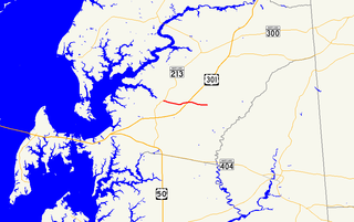
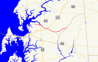
Maryland Route 305 is a state highway in the U.S. state of Maryland. Known as Hope Road, the highway runs 5.08 miles (8.18 km) from MD 213 in Centreville east to an intersection with Hayden Road and Dean Road at Hope east of its intersection with U.S. Route 301 in central Queen Anne's County. MD 305 was constructed in the early 1910s and early 1920s. The highway was planned to extend to Ingleside, but only one segment of that extension was built at the Ingleside end in the mid-1940s. That disjoint part of MD 305 was removed from the state highway system in the early 1960s.

Maryland Route 19 is a state highway in the U.S. state of Maryland. Known for much of its length as Roberts Station Road, the highway runs 8.60 miles (13.84 km) from MD 213 in Church Hill east to MD 313 at Ingleside. MD 19 runs through central Queen Anne's County, connecting both communities with U.S. Route 301 near the road's namesake community. The highway was one of the original state roads marked for improvement in 1909 and was paved in the mid-1910s. MD 19 was widened and extended to its present eastern terminus in the early 1950s. The state highway was extended to its present western terminus in 1970.
Fishing Creek is an unincorporated community and census-designated place (CDP) in Dorchester County, Maryland, United States, on Upper Hoopers Island. As of the 2010 census, the population of Fishing Creek was 163.

Marydel is an unincorporated community in Kent County, Delaware, United States. It lies along Delaware Route 8 west of the city of Dover, the county seat of Kent County and Delaware's state capital. Because the community has borne multiple names, the Board on Geographic Names officially designated it "Marydel" in 1897. Although it is unincorporated, it has a post office, with the ZIP code of 19964. The post office is shared with Marydel, Maryland and is located in Maryland.
Harbeson is an unincorporated community in east central Sussex County, Delaware, United States. It lies at the intersection of U.S. Route 9/Delaware Route 404 and Delaware Route 5, east of the town of Georgetown, the county seat of Sussex County. Its elevation is 36 feet (11 m). Although it is unincorporated, it has a post office, with the ZIP code of 19951.
Forest Hill is an unincorporated community in Harford County, Maryland, United States, located north of the county seat of Bel Air. The main part of town is located at the intersection of Maryland Route 24 and Jarrettsville Road. Until 1958, this community was served by the Maryland and Pennsylvania Railroad at milepost 30.3.
Nottingham is an unincorporated community in Baltimore County, Maryland, United States. Its elevation is 62 feet (19 m). Although Nottingham is unincorporated, it has a post office, with the ZIP code of 21236. Nottingham is often considered a broad area in Baltimore County, encompassing many census-designated places (CDPs) and unincorporated communities. There is also a historical town in Prince George's County, MD that was named Nottingham - it is now an archeological site.
Brinklow is an unincorporated community in Montgomery County, Maryland, United States. Brinklow is located on Maryland Route 650 3 miles (4.8 km) northeast of Olney. Brinklow has a post office with ZIP code 20862.
Spencerville is an unincorporated community and census-designated place in Montgomery County, Maryland, United States. Spencerville is 1 mile (1.6 km) north of Cloverly. Spencerville has a post office with ZIP code 20868.

Price is an unincorporated community in Queen Anne's County, Maryland, United States. Price is located at the junction of U.S. Route 301 and Maryland Route 405 3.5 miles (5.6 km) south-southeast of Church Hill. Price has a post office with ZIP code 21656.
Woolford is an unincorporated community in Dorchester County, Maryland, United States. Woolford is located on Maryland Route 16 1.5 miles (2.4 km) west of Church Creek. Woolford has a post office with ZIP code 21677.
Toddville is an unincorporated community in Dorchester County, Maryland, United States. Toddville is 1.5 miles (2.4 km) northeast of Wingate. Toddville has a post office with ZIP code 21672.

Ingleside is a neighborhood in Holyoke, Massachusetts located to the south of the city center, approximately 2 miles from downtown. The neighborhood features access to the Connecticut River through the Sue Ellen Panitch River Center and the Land of Providence reservation. Ingleside is also home to the Holyoke Mall, the Nuestras Raices farm, the Sisters of Providence of Holyoke, the Providence Behavioral Health Hospital, and several recreational and historical venues.
The Record-Observer newspaper serves Centreville, Maryland and is published once a week on Thursdays, with a readership of approximately 5,000, and a 2014 print circulation of 2,876.