China-Myanmar Economic Corridor (CMEC) is a number of infrastructure projects supporting connectivity between Myanmar and China. It is an economic corridor of the Belt and Road Initiative. [1] [2] [3]
China-Myanmar Economic Corridor (CMEC) is a number of infrastructure projects supporting connectivity between Myanmar and China. It is an economic corridor of the Belt and Road Initiative. [1] [2] [3]
The infrastructure development plan calls for building road and rail transportation from Yunnan Province in China through Muse and Mandalay to the seaport city, Kyaukpyu in Rakhine State. [4] The transportation route follows gas and oil pipelines built in 2013 and 2017. [2] At the end of the route, a port and Special Economic Zone is planned at Khaukphyu. The largest construction project along the route is the 431-kilometre (268 mi) Muse-Mandalay Railway, a project estimated to cost US$9 billion. The newly built railway would connect to the Chinese railway network at Ruili, Yunnan province. [5]
An important part of the corridor will be three core zones at the border of both countries. [6] The core zones will be commercial areas with duty-free concessions, hotels, manufacturing, and financial services. According to a policy plan in 2019 by the Myanmar Ministry of Commerce, the locations for the core zones would be Muse and Chinshwehaw in the northern part of Shan State and Kan Pite Tee in Kachin State. [7]

Yunnan, is a landlocked province in Southwest China. The province spans approximately 394,000 km2 (152,000 sq mi) and has a population of 48.3 million. The capital of the province is Kunming. The province borders the Chinese provinces of Guizhou, Sichuan, autonomous regions of Guangxi and Tibet, as well as Southeast Asian countries Vietnam, Laos, and Myanmar. Yunnan is China's fourth least developed province based on disposable income per capita in 2014.
The Trans-Asian Railway(TAR) is a project to create an integrated freight railway network across Europe and Asia. The project is of the United Nations Economic and Social Commission for Asia and the Pacific (UNESCAP).

The Asian Highway Network (AH), also known as the Great Asian Highway, is a cooperative project among countries in Asia and the United Nations Economic and Social Commission for Asia and the Pacific (ESCAP) to improve their connectivity via highway systems. It is one of the three pillars of the Asian Land Transport Infrastructure Development (ALTID) project, endorsed by the ESCAP commission at its 48th session in 1992, comprising Asian Highway, Trans-Asian Railway (TAR) and facilitation of land transport projects.

The Eurasian Land Bridge, sometimes called the New Silk Road, is the rail transport route for moving freight and passengers overland between Pacific seaports in the Russian Far East and China and seaports in Europe. The route, a transcontinental railroad and rail land bridge, currently comprises the Trans-Siberian Railway, which runs through Russia and is sometimes called the Northern East-West Corridor, and the New Eurasian Land Bridge or Second Eurasian Continental Bridge, running through China and Kazakhstan. As of November 2007, about one percent of the $600 billion in goods shipped from Asia to Europe each year were delivered by inland transport routes.
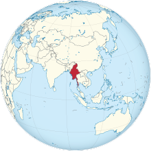
Kyaukphyu is a major town in Rakhine State, in western Myanmar. It is located on the north western corner of Yanbye Island on Combermere Bay, and is 250 miles (400 km) north-west of Yangon. It is the principal town of Kyaukphyu Township and Kyaukphyu District. The town is situated on a superb natural harbor which connects the rice trade between Calcutta and Yangon. The estimated population in 1983 was 19,456 inhabitants. The population of Kyaukphyu's urban area is 20,866 as of 2014, while Kyaukphyu Township's population is 165,352.

The Gwadar Port is situated on the Arabian Sea at Gwadar in Balochistan province of Pakistan and is under the administrative control of the Maritime Secretary of Pakistan and operational control of the China Overseas Port Holding Company. The port features prominently in the China–Pakistan Economic Corridor (CPEC) plan, and is considered to be a link between the Belt and Road Initiative and the Maritime Silk Road projects. It is about 120 kilometres (75 mi) southwest of Turbat, and 170 kilometres (110 mi) to the east of Chabahar Port.

Sino-Myanmar pipelines refers to the oil and natural gas pipelines linking Myanmar's deep-water port of Kyaukphyu (Sittwe) in the Bay of Bengal with Kunming in Yunnan province of China.
The Ministry of Development of North Eastern Region is a Government of India ministry, established in September 2001, which functions as the nodal Department of the Central Government to deal with matters related to the socio-economic development of the eight States of Northeast India: Arunachal Pradesh, Assam, Manipur, Meghalaya, Mizoram, Nagaland, Tripura and Sikkim. It acts as a facilitator between the Central Ministries/ Departments and the State Governments of the North Eastern Region in the economic development including removal of infrastructural bottlenecks, provision of basic minimum services, creating an environment for private investment and to remove impediments to lasting peace and security in the North Eastern Region.

Muse is the capital of Mu Se Township in northern Shan State, Myanmar. It is a border town situated on the Shweli River, and is connected by a bridge to Ruili in Yunnan Province, China. The town is a major regional trade hub with China, accounting for 70% of cross-border trade between the two nations.

The Kunming–Singapore railway is a network of railways that connects China, Singapore and all the countries of mainland Southeast Asia. The concept originated with the British and French colonial empires, which sought to link the railways they had built in southwest China, Indochina and Malaya, but international conflicts in the 20th century kept regional railways fragmented. The idea was formally revived in October 2006 when 18 Asian and Eurasian countries signed the Trans-Asian railway Network Agreement, which incorporated the Kunming–Singapore railway into the Trans-Asian railway network.
The Dali–Ruili railway or Darui railway (大瑞铁路), is a single-track electrified railway under construction in Yunnan Province of Southwest China. The line is slated to run 336.39 km (209 mi) from Dali to Ruili on the border with Myanmar. The line traverses rugged terrain, and bridges and tunnels will account for 75% of the total track length, including the 34.5 km Gaoligongshan Tunnel through the Gaoligong Mountains.

The Bangladesh, China, India and Myanmar Economic Corridor (BCIM) was a proposed corridor connecting India and China through Myanmar and Bangladesh as a corridor.

The Kaladan Road Project is a US$484 million project connecting the eastern Indian seaport of Kolkata with Sittwe seaport in Rakhine State, Myanmar by sea. In Myanmar, it will then link Sittwe seaport to Paletwa in Chin State via the Kaladan river boat route, and then from Paletwa by road to Mizoram state in Northeast India. All components of the project, including Sittwe port and power, river dredging, Paletwa jetty, have been completed, except the under construction Zorinpui-Paletwa road. Originally, the project was scheduled to be completed by 2014, but end-to-end project is expected to be fully operational only by December 2023 as per November 2023 update.

China–Pakistan Economic Corridor (CPEC) is a 3,000 km Chinese infrastructure network project in construction in Pakistan. This sea-and-land-based corridor is aimed to secure and reduce the passage for China's energy imports from the Middle East, by avoiding the existing route from the Straits of Malacca between Malaysia and Indonesia, which, in case of war could be blockaded, and thus hamper the Chinese energy-dependent economic avenues. Developing a deep water port at Gwadar in the Arabian Sea and a well built road and rail line from this port to Xinjiang region in western China would be a shortcut for boosting the trade between Europe and China. In Pakistan, it aims to overcome an electricity shortfall, infrastructural development and modernize transportation networks. Along with shifting it from an agricultural based economic structure to industrial based.

The economy of Chongqing, China, has developed rapidly since it was separated from the Sichuan and became a centrally-administered municipality in 1997. In 2019, it was the sixth-largest Chinese city economy and ranked as China's third-largest municipal economy. In China's overall layout, Chongqing is also important for connecting China's underdeveloped western region with its more advanced eastern region, as well as promoting the economy of the mid-lower reaches of Yangtze river and the central western region.
Arunachal Frontier Highway (AFH), officially notified as the National Highway NH-913 and also called Bomdila-Vijaynagar Highway (BVH), connecting Bomdila Airstrip ALG & HQ in northwest to Vijaynagar Airstrip ALG & HQ in southeast via Nafra HQ-Sarli HQ-Huri Helipad ALG & HQ-Nacho HQ-Mechuka Airstrip ALG & HQ-Monigong HQ-Jido -Hunli HQ-Hayuliang Airstrip ALG HQ-Chenquenty-Hawai HQ-Miao HQ including 800 km greenfield section and network of new tunnels & bridges, is a 2-lane paved-shoulder under-construction national highway along the India-China LAC-McMahon Line border in the Indian state of Arunachal Pradesh. The 1,748 km-long (1,086 mi) highway itself will cost ₹27,000 crore and total cost including 6 additional inter-corridors is ₹40,000 crore. In some places, this highway will run as close as 20 km from the LAC. To be constructed by MoRTH in 9 packages, all packages will be approved by the end of fy 2024-25 and construction will be completed in 2 years by 31 March 2027. Of the total route, 800km is greenfield, rest brownfield will be upgraded and tunnels will be built. This highway in the north & east Arunachal along the China border, would complement the Trans-Arunachal Highway and the Arunachal East-West Corridor as major highways spanning the whole state, pursuing the Look East connectivity policy.
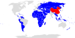
The Belt and Road Initiative, known within China as the One Belt One Road or OBOR/1B1R for short, sometimes referred to as the New Silk Road, is a global infrastructure development strategy adopted by the Chinese government in 2013 to invest in more than 150 countries and international organizations. It is considered a centerpiece of the Chinese leader Xi Jinping's foreign policy. The BRI forms a central component of Xi's "Major Country Diplomacy" strategy, which calls for China to assume a greater leadership role for global affairs in accordance with its rising power and status. It has been compared to the American Marshall Plan. As of August 2023, 155 countries were listed as having signed up to the BRI. The participating countries include almost 75% of the world's population and account for more than half of the world's GDP.

India–Myanmar–Thailand Trilateral Highway, 1,360 km (850 mi) long route, is a 4-lane highway under construction under India's Look East policy that will connect Moreh, India with Mae Sot, Thailand via Myanmar. Imphal-Mandalay-Bangkok 1,813 km (1,127 mi) route, consisting of Imphal-Mandalay 584 km (363 mi) and Mandalay-Bangkok 1,397 km (868 mi), is a highway in good condition except for 101 km (63 mi) part of 120 km (75 mi) long Kalewa-Yagyi stretch being built to 2-lane in each direction highway by India.
The New International Land-Sea Trade Corridor is a trade and logistics passage with an operational hub centered on Chongqing. According to Xinhua the corridor was connected to 190 ports in 90 countries in September 2019. It is one of many corridors under the Belt and Road Initiative, a global economic connectivity program organized by China.
| | This China-related article is a stub. You can help Wikipedia by expanding it. |
| | This article about foreign relations is a stub. You can help Wikipedia by expanding it. |
| | This Myanmar-related article is a stub. You can help Wikipedia by expanding it. |