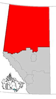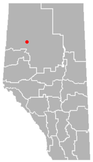
Deadwood is a hamlet in Alberta, Canada within the County of Northern Lights. It is located on Highway 690, approximately 10 kilometres (6.2 mi) east of the Mackenzie Highway, 80 kilometres (50 mi) north of Peace River and 34 kilometres (21 mi) southeast of Manning.
Barillas is a town and municipality located in the province and autonomous community of Navarre, northern Spain.

Sarbia is a village in the administrative district of Gmina Czarnków, within Czarnków-Trzcianka County, Greater Poland Voivodeship, in west-central Poland. It lies approximately 8 kilometres (5 mi) north-east of Czarnków and 63 km (39 mi) north of the regional capital Poznań.
Turowiec is a settlement in the administrative district of Gmina Brusy, within Chojnice County, Pomeranian Voivodeship, in northern Poland. It lies approximately 10 kilometres (6 mi) south-west of Brusy, 14 km (9 mi) north-east of Chojnice, and 89 km (55 mi) south-west of the regional capital Gdańsk.

Swarożyn is a village in the administrative district of Gmina Tczew, within Tczew County, Pomeranian Voivodeship, in northern Poland. It lies approximately 8 kilometres (5 mi) south-west of Tczew and 37 km (23 mi) south of the regional capital Gdańsk.
Cierpkie is a village in the administrative district of Gmina Pasłęk, within Elbląg County, Warmian-Masurian Voivodeship, in northern Poland. It lies approximately 4 kilometres (2 mi) south of Pasłęk, 19 km (12 mi) south-east of Elbląg, and 61 km (38 mi) north-west of the regional capital Olsztyn.
Makowo is a village in the administrative district of Gmina Iława, within Iława County, Warmian-Masurian Voivodeship, in northern Poland. It lies approximately 12 kilometres (7 mi) north-east of Iława and 57 km (35 mi) west of the regional capital Olsztyn.

Brownvale is a hamlet in northern Alberta, Canada within the Municipal District of Peace No. 135. It is located on Highway 737 less than 1 kilometre (0.62 mi) off Highway 2, approximately 48 kilometres (30 mi) southwest of the Town of Peace River and 20 kilometres (12 mi) southwest of Grimshaw. Duncan's First Nation reserve is less than 5 km (3.1 mi) to the south.
Chinook is a hamlet in southern Alberta, Canada within Special Area No. 3. It is located on Highway 9 approximately 119 kilometres (74 mi) northeast of Brooks.
Faust is a hamlet in northern Alberta within Big Lakes County, located 1 kilometre (0.62 mi) north of Highway 2, approximately 241 kilometres (150 mi) northwest of Edmonton.
Guy is a hamlet in northern Alberta, Canada within the Municipal District of Smoky River No. 130. It is located on Highway 49, approximately 113 kilometres (70 mi) northeast of Grande Prairie. It is the home of Honey Bunny honey products.
Hotchkiss is an unincorporated community in northern Alberta under the jurisdiction of the County of Northern Lights.
Imperial Mills is an unincorporated community in northern Alberta in Lac La Biche County, located 33 kilometres (21 mi) northeast of Highway 55, 117 kilometres (73 mi) northwest of Cold Lake.
Jean Cote, or Jean Côté, is a hamlet in northern Alberta, Canada within the Municipal District of Smoky River No. 130. It is located approximately 11 kilometres (6.8 mi) west of Highway 2 and 123 kilometres (76 mi) northeast of Grande Prairie.
Lafond is a hamlet in northern Alberta, Canada within the County of St. Paul No. 19. It is located 5 kilometres (3.1 mi) east of Highway 36, approximately 117 kilometres (73 mi) northwest of Lloydminster.
Notikewin is a hamlet in northern Alberta, Canada within the County of Northern Lights.
Ridgevalley is a hamlet in northern Alberta, Canada within the Municipal District of Greenview No. 16. It is located 2.5 kilometres (1.6 mi) southwest of Highway 43, approximately 57 kilometres (35 mi) east of Grande Prairie.
Silver Valley is an unincorporated community in northern Alberta within Saddle Hills County, located 76 kilometres (47 mi) north of Highway 43, 110 kilometres (68 mi) northwest of Grande Prairie. The area was first opened for homesteaders in 1952.
Tangent is a hamlet in northern Alberta, Canada within Birch Hills County, located 6 kilometres (3.7 mi) north of Highway 49, approximately 98 kilometres (61 mi) northeast of Grande Prairie.
Twin Lakes is an unincorporated place in northern Alberta under the jurisdiction of the County of Northern Lights.