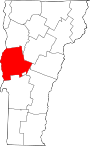
Lake Champlain is a natural freshwater lake in North America. It mostly lies between the U.S. states of New York and Vermont, but also extends north into the Canadian province of Quebec.

Crown Point is a town in Essex County, New York, United States, located on the west shore of Lake Champlain. The population was 2,024 at the 2010 census. The name of the town is a direct translation of the original French name, Pointe à la Chevelure.
Samuel de Champlain (1574–1635) was a French explorer.

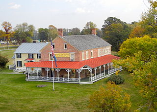
Fort Crown Point was built by the combined efforts of British and Colonial troops from New York and the New England Colonies in 1759 at a narrows on Lake Champlain on the border between New York and Vermont. It was erected to secure the region against the French in upstate New York near the town of Crown Point, and it was the largest earthen fortress built in the American colonies. The fort's ruins are a National Historic Landmark administered as part of Crown Point State Historic Site.
Chimney Point is a peninsula in the town of Addison, Vermont, which juts into Lake Champlain forming a narrows. It is one of the earliest settled and most strategic sites in the Champlain Valley.

Ticonderoga is a museum ship and one of just two remaining sidewheel passenger steamers with an intact walking beam engine of the type that powered countless thousands of American freight and passenger vessels on America's bays, lakes and rivers for more than a century. Commissioned by the Champlain Transportation Company, Ticonderoga was built in 1906 at the Shelburne Shipyard in Shelburne, Vermont on Lake Champlain.

Mount Independence on Lake Champlain in Orwell, Vermont, was the site of extensive fortifications built during the American Revolutionary War by the American army to stop a British invasion. Construction began in July 1776, following the American defeat in Canada, and continued through the winter and spring of 1777. After the American retreat on July 5 and 6, 1777, British and Hessian troops occupied Mount Independence until November 1777.

The Crown Point Road, or the Crown Point Military Road, is a historic road built in 1759-60, mostly in what is now the United States state of Vermont. It was built by British Army and colonial militia forces to connect Fort Crown Point near the southern end of Lake Champlain to the Fort at Number 4 in what is now Charlestown, New Hampshire. It was the first major road in Vermont, spurring development along its route after the French and Indian War. Fragments of the road are still visible in largely period condition, or have been paved over, while others have disappeared into the forest. Sections of the road located in Weathersfield have been listed on the National Register of Historic Places.
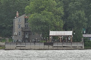
The Larrabee's Point Complex consists of a collection of ferry-related buildings and structures at the western end of Vermont Route 74 in Shoreham, Vermont. Included are facilities currently used by the oldest operating ferry on Lake Champlain, the Ticonderoga-Larrabees Point Ferry, and two buildings historically associated with the ferry operation. The complex was listed on the National Register of Historic Places in 1980.
The Hawley's Ferry House, also known just as the Hawley House, is a historic house on the shore of Lake Champlain in Kingsland Bay State Park, Ferrisburgh, Vermont. Built about 1790, it is one of the few surviving 18th-century buildings on the Vermont side of the lake. It was listed on the National Register of Historic Places in 1978.

The Battery Street Historic District encompasses one of the oldest developed areas of Burlington, Vermont. With a history dating to 1790, this area, south of downtown Burlington and initially bounded roughly by Main, St. Paul, and Maple Streets, and Lake Champlain, this area includes a mix of residential, commercial, and industrial uses, with architecture spanning from its early period to the 20th century, including one of the city's oldest houses. The district was listed on the National Register of Historic Places in 1977, and has twice been enlarged, extending west to South Union Street.

The District School No. 1 is a historic one-room schoolhouse on Lake Road in Panton, Vermont. Built about 1818, the stone building is one of Vermont's oldest district schoolhouses. It was listed on the National Register of Historic Places in 1980.
The Burlington Bay Horse Ferry is a shipwreck in Lake Champlain off Burlington, Vermont, United States. It is the only known example of a turntable horse ferry, a ship type that was common on United States waterways in the mid-19th century. The wreck is a Vermont State Historic Site, and was listed on the National Register of Historic Places in 1993. Its location is marked by buoys in Burlington Bay between the northern end of the Burlington Breakwater and Lone Rock Point, and it is visitable by certified divers.

The Burlington Breakwater is a breakwater providing shelter to the harbor of Burlington, Vermont from the open waters of Lake Champlain. It was built in several stages between 1836 and 1890, and is a rare example of a 19th-century timber-cribbed stone breakwater. It was listed on the National Register of Historic Places in 2003.

The Ira Hill House is a historic house at 2304 Main Streets in Isle La Motte, Vermont. Built in 1822 for a prominent local citizen by James Ritchie, a regionally acclaimed stonemason, it is one of the rural community's finer stone houses of the period. It was listed on the National Register of Historic Places in 2003.

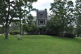
The Follett House is a historic house at 63 College Street in Burlington, Vermont. Built in 1840 for a prominent local businessman, it is the last surviving grand 19th-century lakeside mansion in the city, and one of the state's finest examples of Greek Revival architecture. It was listed on the National Register of Historic Places in 1972. It has seen commercial and institutional uses since 1885.

The McNeil Homestead is a historic ferry-related property off Wings Point Road in Charlotte, Vermont, USA. The complex includes a 19th-century house, former tavern, and barn, all built by members of the McNeil family, the first operators of the Charlotte-Essex Ferry, whose eastern terminus is just south of the property. It was listed on the National Register of Historic Places in 1982.
The O.J. Walker was a cargo schooner that plied the waters of Lake Champlain between New York and Vermont. Built in 1862 in Burlington, Vermont, she hauled freight until sinking off the Burlington coast in a storm in 1895, while carrying a load of brick and tile. The shipwreck, located west of the Burlington Breakwater, is a Vermont State Historic Site, and is accessible to registered divers. It is one of the best-preserved examples of the 1862 class of sailing canal schooners, and was listed on the National Register of Historic Places in 1998.

St. Albans Town Hall is the center of government of the town of St. Albans, Vermont. It is located at 579 Lake Road in the village of St. Albans Bay. It is a Richardsonian Romanesque building, constructed in 1898, two years after the city of St. Albans, the former town center, was politically separated. The building was listed on the National Register of Historic Places in 1996.

The South Willard Street Historic District encompasses what was once the most fashionable residential area of Burlington, Vermont. Located along South Willard Street between Pearl and Beech Streets, the architecturally heterogeneous area was in the 19th century home to major estates of the city's business leaders, and has since been infilled with a variety of late 19th and early 20th century architecture. The district was listed on the National Register of Historic Places in 1988.