Cima Cars

Last updated
Cima Cars
Cima Cars from Monte Grosso.png
The summit from Ellero Valley
Highest point
Elevation 2,218 m (7,277 ft) [1]
Prominence 183 m (600 ft) [2] [1]
Coordinates 44°13′11″N7°42′12″E / 44.2197559°N 7.7034535°E / 44.2197559; 7.7034535 Coordinates: 44°13′11″N7°42′12″E / 44.2197559°N 7.7034535°E / 44.2197559; 7.7034535
Geography
Alps location map.png
Red triangle with thick white border.svg
Cima Cars
Location in the Alps
Location Piemonte, Italy
Parent range Ligurian Alps
Climbing
First ascent ancestral
Easiest route hiking

The Cima Cars is a mountain of the Ligurian Alps located in Piedmont (NW Italy).

Contents

Geography

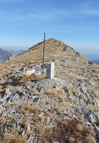
Summit of Cima Cars Cima Cars summit point.png
Summit of Cima Cars

The mountain stands on the ridge dividing the valleys of Ellero and Pesio. Is located between Colletto Pellerina (2.017 m, North) and Colle di Serpentera (2.035 m, South). Westwards from its summit starts a third ridge which divides two tributary valleys of the Pesio, vallone Serpentera (S) and vallone del Funtanin; on this ridge, close to a saddle at 1.985 m and a summit of 2.030 m, stands the Punta Bartivolera (1.957 m). [3] The topographic prominence of Cima Cars is of 183 m, as results from the drop in height between the summit (2.218 m) and Colle di Serpentera (2.035 m), its key col. Some summit crosses stand on subsummits of Cima Cars located on its Ellero valley side.

SOIUSA classification

According to the SOIUSA (International Standardized Mountain Subdivision of the Alps) the mountain can be classified in the following way: [4]

Geology

The area where the mountain stands is of karstic nature. The name Cars itself is linked to this geological feature, [5] as other toponyms of the Ligurian Alps like as Le Carsene, Sella del Cars, Monte Carsino etc. [6]

Access to the summit

Cima Cars con be reached by a waymarked foothpath starting from Pian delle Gorre (Pesio valley), [7] or from the Ellero valley, in this case starting from Ponte Murato (Pian Marchisio). [8]

The mountain is also a classical destination for Ski mountaineering, considered quite engaging (BS - good skiers - difficulty). [9]

Mountain huts

Conservation

The western slopes of the mountain, facing the Pesio Valley, are part of the Natural Park of Marguareis, a nature reserve established by Regione Piemonte.

Related Research Articles

<span class="mw-page-title-main">Monte Carmo di Loano</span> Mountain in Italy

Monte Carmo di Loano is a mountain in Liguria, northern Italy, part of the Ligurian Prealps. It is located in the province of Savona. It lies at an altitude of 1389 metres.

<span class="mw-page-title-main">Monte Frontè</span> Mountain in Italy

Monte Frontè is a mountain in Liguria, northern Italy, part of the Alps. It is located in the province of province of Imperia. It lies at an altitude of 2,152 metres. After Monte Saccarello it is the second highest peak in the Ligurian region.

<span class="mw-page-title-main">Monte Galero</span> Mountain in Italy

Monte Galero is a mountain in Liguria, northern Italy, part of the Alps. It is located in the provinces of Savona and Cuneo. It lies at an altitude of 1708 metres and, after Monte Armetta, is the second highest summit of the Ligurian Prealps.

<span class="mw-page-title-main">Monte Settepani</span> Mountain in Italy

Monte Settepani is 1,386 metres high mountain in Liguria, northern Italy, part of the Ligurian Prealps.

<span class="mw-page-title-main">Colle di Cadibona</span>

Colle di Cadibona - 436 m (1,430 ft) - is a mountain pass between Savona and Altare in the Ligurian Alps, delineating the boundary with the Apennine Mountains. It is also known as Bocchetta di Altare. On the south-eastern side of the Alps Godovič Pass (Slovenia) conventionally represents the opposite end of the Alpine range.

<span class="mw-page-title-main">Cima di Pertegà</span> Mountain in Italy

Cima di Pertegà (Italian) or Cime de la Pertègue (French) is a mountain located on the French-Italian border between Piemonte and Provence-Alpes-Côte d'Azur.

<span class="mw-page-title-main">Cime de Capoves</span> Mountain in Italy

The Cime de Capoves (French) or Cima Capoves (Italian) is a mountain of the Ligurian Alps located in the French region of Provence-Alpes-Côte d'Azur, close to the French-Italian border.

<span class="mw-page-title-main">Carmo di Brocchi</span> Mountain in Italy

Carmo di Brocchi is a 1,610-metre (5,282 ft) mountain of the Ligurian Alps, in Italy.

<span class="mw-page-title-main">Monte Spinarda</span> Mountain in Italy

Monte Spinarda is a 1,357-metre (4,452 ft) mountain of the Ligurian Prealps in Italy.

<span class="mw-page-title-main">Monte Bertrand</span> Mountain in Italy

Monte Bertrand (Italian) or Mont Bertrand (French) is a mountain located on the French-Italian border between Piemonte and Provence-Alpes-Côte d'Azur.

<span class="mw-page-title-main">Cime de Missun</span> Mountain in Italy

The Cime de Mussun (French) or Cima Missun (Italian) is a mountain of the Ligurian Alps.

<span class="mw-page-title-main">Bric Costa Rossa</span> Mountain in Italy

The Bric Costa Rossa is a mountain of the Ligurian Alps located in Piedmont.

<span class="mw-page-title-main">Cima della Fascia</span> Mountain in Italy

The Cima della Fascia is a mountain of the Ligurian Alps located in Piedmont.

<span class="mw-page-title-main">Monte Mongioie</span> Mountain in Italy

The Monte Mongioie is a mountain of the Ligurian Alps located in Piedmont.

<span class="mw-page-title-main">Monte Antoroto</span> Mountain in Italy

The Monte Antoroto is a mountain of the Ligurian Alps located in Piedmont.

<span class="mw-page-title-main">Cima delle Saline</span> Mountain in Italy

The Cima delle Saline is a mountain of the Ligurian Alps located in Piedmont.

<span class="mw-page-title-main">Punta Mirauda</span> Mountain in Italy

The Punta Mirauda is a mountain of the Ligurian Alps located in Piedmont.

<span class="mw-page-title-main">Monte Cianea</span> Mountain in Italy

Monte Cianea is a 1,226-metre (4,022 ft) mountain of the Ligurian Prealps, in Italy.

<span class="mw-page-title-main">Monte Fantino</span> Mountain in Italy

The Monte Fantino is a mountain of the Ligurian Alps located in Piedmont.

The Ligurian Prealps are a mountain range in northwestern Italy. They belong to the Ligurian Alps and are located between the regions of Piemonte and Liguria. Their highest summit is the monte Armetta, at an elevation of 1,739 metres (5,705 ft).

References

  1. 1 2 Fraternali & 1:25.000 map nr.16.
  2. Key col: Colle di Serpentera(2.035 m)
  3. CAI-TCI , p. 371.
  4. Marazzi, Sergio (2005). Atlante Orografico delle Alpi. SOIUSA (in Italian). Priuli & Verlucca. p. 64. ISBN   978-88-8068-273-8.
  5. AA.VV. (Comitato per le onoranze al Prof. G. Gola) (1947). Lavori di botanica. Volume pubblicato in occasione del 70 ̊genetliaco del Prof. Giuseppe Gola (in Italian). Rosenberg & Sellier. p. 211. Retrieved 2020-07-02.
  6. Industria Tipografica Romana, 1939 (1939). Memorie della Società geologica italiana (in Italian). Vol. 2. p. 118. Retrieved 2020-07-02.
  7. andrea81 (6 June 2010). "Cars (Cima) da Pian delle Gorre per il Vallone Serpentera" (in Italian). gulliver.it. Retrieved 2020-07-02.
  8. Chiaretta, Furio; Ceragioli, Filippo; Molino, Aldo (2006). "La Cima Cars (2218)". A piedi in Piemonte (in Italian). Vol. 1. Subiaco. Iter edizioni. pp. 238–239. ISBN   88-8177-115-2.
  9. "Cars (Cima) da Madonna d'Ardua per il Vallone Serpentera" (in Italian). gulliver.it. 22 May 2008. Retrieved 2020-07-02.

Bibliography

Maps

Commons-logo.svg Media related to Cima Cars at Wikimedia Commons