Cima della Fascia

Last updated
Cima della Fascia
Cima della Fascia da nord.png
The summit as seen from its N shoulder
Highest point
Elevation 2,495 m (8,186 ft) [1]
Prominence 276 m (906 ft) [2] [1]
Coordinates 44°16′12″N7°36′21″E / 44.269973°N 7.605758°E / 44.269973; 7.605758 Coordinates: 44°16′12″N7°36′21″E / 44.269973°N 7.605758°E / 44.269973; 7.605758
Geography
Alps location map.png
Red triangle with thick white border.svg
Cima della Fascia
Location in the Alps
Location Piemonte, Italy
Parent range Ligurian Alps
Climbing
First ascent ancestral
Easiest route hiking

The Cima della Fascia is a mountain of the Ligurian Alps located in Piedmont (NW Italy).

Contents

Geography

The mountain stands on the ridge dividing the valleys of Vermenagna and Pesio. [3] Southwards the water divide continues heading to the Punta Mirauda and Bric Costa Rossa, while northwards in connects Cima della Fascia with the main chain of the Alps. The summit, which offers a very vast panorama, is marked by a cairn bearing a metallic summit cross; in the base of the cairn a box contains the summit register.

SOIUSA classification

According to the SOIUSA (International Standardized Mountain Subdivision of the Alps) the mountain can be classified in the following way: [4]

Geology

Karstic cliffs facing the Vallone del Cros Cima della Fascia dal vallone del Cros.png
Karstic cliffs facing the Vallone del Cros

The mountain stands in a karstic area. Its basement is mainly formed of Triassic limestone, the intermediate portion of younger limestone, of Jurassic origin, and the summit of layers of Eocenic schists. [5]

Conservation

The eastern slopes of the mountain, facing the Pesio Valley, are part of the Natural Park of Marguareis, a nature reserve established by Regione Piemonte.

Access to the summit

Cima della Fascia summit cross, on its right the Bric Costa Rossa Cima della Fascia croce di vetta a destra il Bric Costa Rossa.png
Cima della Fascia summit cross, on its right the Bric Costa Rossa

The Cima della Fascia can be reached hiking from Limone Piemonte. [6] The mountain is also accessible in winter by ski mountaineers, with quite a demanding itinerary. [7]

Maps

Related Research Articles

Ligurian Alps Mountain range in Italy and France

The Ligurian Alps are a mountain range in northwestern Italy. A small part is located in France. They form the south-western extremity of the Alps, separated from the Apennines by the Colle di Cadibona. The Col de Tende and the Vermenagna valley separate them from the Maritime Alps. They form the border between Piedmont in the north and Liguria in the south.

Monte Frontè

Monte Frontè is a mountain in Liguria, northern Italy, part of the Alps. It is located in the province of province of Imperia. It lies at an altitude of 2,152 metres. After Monte Saccarello it is the second highest peak in the Ligurian region.

Punta Marguareis

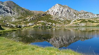
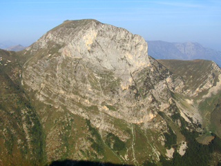
The Punta Marguareis (It) or Pointe Marguareis (Fr) is a mountain in the Ligurian Alps, on the boundary between Italy and France; It is the highest peak of the Ligurian Alps.

Monte Tanarello

Monte Tanarello (Italian) or Mont Tanarel (French) is a 2094 metres high mountain located on the French-Italian border.

Punta Sulè Mountain in Italy

Punta Sulè is a 3,384 m a.s.l.mountain of the Graian Alps, located in Italy.

Cima di Pertegà

Cima di Pertegà (Italian) or Cime de la Pertègue (French) is a mountain located on the French-Italian border between Piemonte and Provence-Alpes-Côte d'Azur.

Cime de Capoves

The Cime de Capoves (French) or Cima Capoves (Italian) is a mountain of the Ligurian Alps located in the French region of Provence-Alpes-Côte d'Azur, close to the French-Italian border.

Monte Monega Mountain in Italy

Monte Monega is a 1,882-metre (6,175 ft) mountain of the Ligurian Alps, in Italy.

Carmo di Brocchi Mountain in Italy

Carmo di Brocchi is a 1,610-metre (5,282 ft) mountain of the Ligurian Alps, in Italy.

Monte Bertrand

Monte Bertrand (Italian) or Mont Bertrand (French) is a mountain located on the French-Italian border between Piemonte and Provence-Alpes-Côte d'Azur.

Cime de Missun

The Cime de Mussun (French) or Cima Missun (Italian) is a mountain of the Ligurian Alps.

Bric Costa Rossa Mountain in Italy

The Bric Costa Rossa is a mountain of the Ligurian Alps located in Piedmont.

Monte Mongioie Mountain in Italy

The Monte Mongioie is a mountain of the Ligurian Alps located in Piedmont.

Monte Antoroto Mountain in Italy

The Monte Antoroto is a mountain of the Ligurian Alps located in Piedmont.

Natural Park of Marguareis Nature reserve in Italy

The Natural Park of Marguareis(in Italian Parco Naturale del Marguareis) is a regional natural park of the Ligurian Alps located in the Province of Cuneo.

Cima delle Saline Mountain in Italy

The Cima delle Saline is a mountain of the Ligurian Alps located in Piedmont.

Monte Capezzone Mountain in Italy

The Monte Capezzone is a mountain in the Pennine Alps of north-western Italy; with an elevation of 2,421 m (7,943 ft) is the highest peak of the Strona Valley.

Punta Mirauda Mountain in Italy

The Punta Mirauda is a mountain of the Ligurian Alps located in Piedmont.

Cima Cars Mountain in Italy

The Cima Cars is a mountain of the Ligurian Alps located in Piedmont.

Monte Fantino Mountain in Italy

The Monte Fantino is a mountain of the Ligurian Alps located in Piedmont.

References

  1. 1 2 1:25.000 map nr.16 "Val Vermenagna Valle Pesio Alta val Ellero Parco naturale del Marguareis" (Map). Ciriè: Fraternali.
  2. Key col: Colla Bassa di Malaberga (2.219 m)
  3. Carta in scala 1:50.000 n. 8 Alpi Marittime e Liguri (Map). Torino: Istituto Geografico Centrale.
  4. Marazzi, Sergio (2005). Atlante Orografico delle Alpi. SOIUSA (in Italian). Priuli & Verlucca. p. 64. ISBN   978-88-8068-273-8.
  5. Memorie della Società geologica italiana (in Italian). Vol. 2. Industria Tipografica Romana. 1939. p. 247. Retrieved 2019-07-20.
  6. "Tetti Barat (Limone) - Capanna Chiara - Vallone del Cros - Cima della Fascia" (in Italian). L'appenninista. September 2017. Retrieved 2019-07-20.
  7. "Scheda tecnica - Cima della Fascia da Limone Piemonte" (PDF) (in Italian). cuneoclimbing. Retrieved 2019-07-20.

Commons-logo.svg Media related to Cima della Fascia at Wikimedia Commons