City of Henrico (Virginia Company)

Last updated
City of Henrico
Colonial incorporation of England
1619–1634
Approximate Boundaries of the City of Henrico in 1619.jpg

Approximate boundaries of the City of Henrico in 1619 (in purple) as described by Alexander Brown. [1]
History 
 Instructions from Virginia Company create City of Henrico
1619
  Powhatan attack destroys Henricus
1622
 Virginia becomes royal colony
1624
 Shire of Henrico established
1634
Today part of Virginia, United States of America

The City of Henrico (also known as Henrico) is one of the oldest counties in the Colony of Virginia. It was one of four incorporations established in the colony by its proprietor, the Virginia Company. The City of Henrico, which included the settlement of Henricus, was the furthest incorporation upstream on the James River. In 1634, Henrico was reorganized under royal authority as the shire of Henrico, one of eight shires in the Crown Colony of Virginia, Later, it became known as Henrico County, Virginia.

Contents

History

The City of Henrico was formed in 1618 when the Virginia Company, the proprietor of the colony of Virginia, provided instructions to Governor Sir George Yeardley for the reorganization of the colony's government. [2] : 98 These instructions provided for the incorporation of most of the plantations and developments of Virginia into four boroughs or cities that extended across the James River, the main conduit of transportation of the era. These incorporations were called James City, Charles City, Kiccowtan [note 1] and Henrico. The seat of the colony's government was in Virginia's only major town, Jamestown in James City.

The City of Henrico's major settlement was the fortified town of Henricus, which was founded by Sir Thomas Dale on what is now known as Farrar's Island, [3] near the location of the Dutch Gap Canal today. Henrico had been founded to eventually replace Jamestown as a healthier and militarily more secure seat of the colony's government. By 1612, Alexander Whitaker, the "apostle to Virginia" who married John Rolfe and Pocahontas, became Henricus's first minister [4] the surrounding lands were designated for the first English college in North America,. [5] and the Falling Creek Ironworks, the first iron production facility in North America, [6] were founded there.

However, by the time the City of Henrico was incorporated in 1619, the town of Henricus was already in a state of dilapidation. [7] The town, the ironworks, and the plan for a college was abandoned after the Powhatan attack of 1622. [8] Initially, the attack had an adverse effect on Henrico's settlement: 1624, 29 people as living in Henrico, all on the former college lands [9] and in 1625, 22 people were listed as living there. [10] However, the City of Henrico's population continued to increase in the following decade.

Jurisdiction

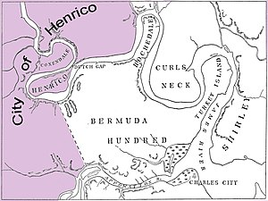
In 1619, the original area of the City of Henrico included the northernmost region of the colony. [1] The northern section incorporated lands around Henricus and Farrar's Island, as well as the settlements of Coxendale, which was on the south bank of the James just east of Farrar's Island, [11] and Arrohattock, which was further upstream from Henricus; [12] South of Farrar's Island, the city included the lands west of Dale's Pale, a defensive work with palisades and a ditch that crossed the neck of the Bermuda Hundred Peninsula from the James river to the falls of the Appomattox River. [13] The city boundaries ended on the Appomattox, where it bordered Charles City.

At its founding, the City of Henrico did not have a governmental seat. All legal issues in the City of Henrico were originally adjudicated by the governor and councillors in Jamestown who served as the Council Court. [14] : 33 In 1626, the Council of Virginia established a monthly court, which could meet either at Jordan's Journey or Shirley Hundred. Both of these locations were in Charles City, but they served the "Upper Parts" of the James River, which included both Charles City and Henrico. [15] These courts handled civil cases [14] : 45–46 concerning amounts under the value of 100 pounds of tobacco in 1626 [16] : 125 [note 2] , which was increased to five pounds sterling in 1632. [16] : 168 There were six commissioners in the monthly court of the Upper Parts. The councillor William Farrar served as the city's head commissioner from the founding of the court in 1626 to after his reappointment in 1632 by Governor Sir John Harvey, being given the choice of where court was to be held in the 1626 commission [15] and explicitly required to be present at all cases and having the authority to hand down final decision on all cases in the 1632 reappointment [16] : 168 However criminal cases, civil cases involving large amounts of money, and appeals of decisions by the monthly court were decided by the Council Court in Jamestown. [14] : 55

The Shire of Henrico

The eight shires of Virginia created in 1634 with Henrico in purple 1634 Virginia Counties- Henrico Focus.jpg
The eight shires of Virginia created in 1634 with Henrico in purple

In 1634, City of Henrico became the Shire of Henrico, one of eight shires in the Royal Colony of Virginia. [16] : 224 The shire was apportioned lands formerly belonging to Charles City, including Bermuda Hundred and more easterly parts of the northern bank of the James River. The boundaries of Henrico shire was the Chickahominy River in the north, Turkey Creek and the Appomattox River in the east, the Appomattox River in the south, with the west remaining unbounded. [18] By 1642, the Shire of Henrico was already being referred to by its current name, Henrico County, during legislative sessions. [16] : 239

The county seat of Henrico was established at Varina Plantation and a courthouse was built there sometime before 1688. [19] The courthouse remained at Varina until 1752, when a new one was built in Richmond. [20]

Notes

  1. Kiccowtan, whose modern spelling is Kecoughtan, was renamed Elizabeth City in 1620 [2] : 276 by the Virginia Company in response to the legislative assembly in Virginia's petition to change Kiccowtan's "savage" name [2] : 161
  2. During the time between 1619 and 1630, tobacco was the primary currency in the colony [17]

Related Research Articles

<span class="mw-page-title-main">Prince George County, Virginia</span> County in Virginia, United States

Prince George County is a county located in the Commonwealth of Virginia. As of the 2020 census, the population was 43,010. Its county seat is Prince George.

<span class="mw-page-title-main">Henrico County, Virginia</span> County in Virginia, United States

Henrico County, officially the County of Henrico, is a county located in the Commonwealth of Virginia in the United States. As of the 2020 census, the population was 334,389 making it the fifth-most populous county in Virginia. Henrico County is included in the Greater Richmond Region. There is no incorporated community within Henrico County; therefore, there is no incorporated county seat either. Laurel, an unincorporated CDP, serves this function.

<span class="mw-page-title-main">Charles City County, Virginia</span> County in Virginia, United States

Charles City County is a county located in the U.S. commonwealth of Virginia. The county is situated southeast of Richmond and west of Jamestown. It is bounded on the south by the James River and on the east by the Chickahominy River.

<span class="mw-page-title-main">John Rolfe</span> English-born explorer, farmer, and merchant

John Rolfe was an English explorer, farmer and merchant. He is best known for being the husband of Pocahontas and the first settler in the colony of Virginia to successfully cultivate a tobacco crop for export.

Thomas Dowse, also known as Thomas Dawse and Thomas Dawles was an English-American immigrant who represented City of Henricus in the first meeting of the House of Burgesses on July 30, 1619 at Jamestown, Virginia.

<span class="mw-page-title-main">Henricus</span> Archaeological site in Virginia, United States

The "Citie of Henricus"—also known as Henricopolis, Henrico Town or Henrico—was a settlement in Virginia founded by Sir Thomas Dale in 1611 as an alternative to the swampy and dangerous area around the original English settlement at Jamestown, Virginia. It was named for Henry, Prince of Wales (1594–1612), the eldest son of King James I.

<span class="mw-page-title-main">St. John's Episcopal Church (Richmond, Virginia)</span> Historic church in Virginia, United States

St. John's Church is an Episcopal church located at 2401 East Broad Street in Richmond, Virginia, United States. Formed from several earlier parishes, St. John's is the oldest church in the city of Richmond, Virginia. It was built in 1741 by William Randolph's son, Colonel Richard Randolph; the Church Hill district was named for it. It was the site of two important conventions in the period leading to the American Revolutionary War, and is famous as the location where American Founding Father Patrick Henry gave his memorable speech at the Second Virginia Convention, closing with the often-quoted demand, "Give me liberty, or give me death!" The church is designated as a National Historic Landmark.

<span class="mw-page-title-main">Varina, Virginia</span> Former unincorporated community and current magisterial district in Virginia, United States

Varina is a former unincorporated community and current magisterial district in the easternmost portion of Henrico County, Virginia, United States.

<span class="mw-page-title-main">Varina Farms</span> Historic house in Virginia, United States

Varina Farms, also known as Varina Plantation or Varina Farms Plantation or Varina on the James, is a plantation established in the 17th century on the James River about 10 miles (16 km) south of Richmond, Virginia. An 820-acre (330 ha) property was listed on the National Register of Historic Places in 1977 as "Varina Plantation". At that time it included two contributing buildings and one other contributing site.

<span class="mw-page-title-main">Jordan Point, Virginia</span> Unincorporated community in Virginia, United States

Jordan Point is a small unincorporated community on the south bank of the James River in the northern portion of Prince George County, Virginia, United States. It is about 20 miles from Richmond and 30 miles upstream from Jamestown on the James River. It was the location of extensive archeological research between 1987 and 1993. This research provided substantial information about human existence in the area from the prehistoric to the late colonial eras. In particular, the research extensively studied the Jordan's Journey settlement that existed between 1620 and 1640 during early years of the Virginia colony.

Captain Samuel Mathews was a Virginia planter, political figure, and the father of Governor Samuel Mathews.

George Thorpe, was a noted landowner, Member of Parliament, distiller, educator and major investor in early colonial companies in the Americas.

<span class="mw-page-title-main">Richard Buck (chaplain)</span> US colonial Virginia minister 1610–1624

Reverend Richard Buck was a minister to the Colony of Virginia at Jamestown, Virginia from 1610 to 1624. He was chaplain of the first session of the Virginia General Assembly, which was composed of the House of Burgesses and the Virginia Governor's Council. This assembly met in the church at Jamestown on July 30, 1619, as the first elected assembly and law making body in colonial America.

<span class="mw-page-title-main">William Farrar (settler)</span> Early settler, member of the Virginia Council, and Commissioner in the Virginia colony

William Farrar was a landowner and politician in colonial Virginia. He was a subscriber to the third charter of the Virginia Company who immigrated to the colony from England in 1618. After surviving the Jamestown massacre of 1622, he moved to Jordan's Journey. In the following year, Farrar became involved in North America's first breach of promise suit when he proposed to Cecily Jordan.

<span class="mw-page-title-main">Farrar's Island</span> Peninsula in Chesterfield County, Virginia

Farrar's Island is a peninsula on the west side of the James River in Chesterfield County, Virginia. It is the site of the Dutch Gap Conservation Area and Boat Landing and the Henricus Historical Park. Originally, Farrar's Island was formed by a meander loop in the James River and lay on the east side of the James River. At its smallest point, the neck of the peninsula was less than 400 feet wide. At that time, Farrar's Island was slightly less than 700 acres and lay about 15 miles (24 km) south of the James River fall line at Richmond, Virginia.

Samuel Sharpe, sometimes referred to as Samuel Sharp was an early Virginia colonist who settled in the area that became Charles City County, Virginia. He came to Virginia in 1610 with most of the passengers and crew of the Sea Venture as they made their way to the colony after 10 months in Bermuda. They had wrecked in a storm there and built two small boats to complete their journey to Jamestown. Along with Samuel Jordan, he represented Charles City as a burgess in the first general assembly of the Virginia House of Burgesses in Jamestown, Virginia in 1619. He was a representative for Westover, an incorporation of Charles City, in the 1623/24 assembly and signed a letter along with several burgesses at the time of that assembly.

William Sharpe was an early Virginia colonist, soldier, ancient planter, and Virginia Company shareholder who settled in the Bermuda Hundred area that became part of Charles City County, Virginia. He served in the Virginia House of Burgesses in Jamestown, Virginia, in 1629.

John Pollington was an early Virginia colonist who was a member of the first assembly of the Virginia House of Burgesses at Jamestown, Virginia in 1619 for the "Citie" of Henricus, Virginia. In 1624, he was a burgess for Warrosquyoake Shire sometimes shown as Warresqueak and other variations, now Isle of Wight County, Virginia. He also was a landowner and merchant.

References

  1. 1 2 Brown, Alexander (1898). The First Republic in America. Boston, MA: Houghton, Mifflin. p. 312. Lock-green.svg
  2. 1 2 3 Kingsbury, Susan Myra, ed. (1933). Records of the Virginia Company of London. Vol. 3. Washington DC: Government Printing Office. Lock-green.svg
  3. Surface, G. T. (1907). "Geographic Influence on the Economic History of Virginia". Bulletin of the American Geographical Society. 39 (7): 402. doi:10.2307/198932. JSTOR   198932 .
  4. Porter, Harry C. (1957). "Alexander Whitaker: Cambridge Apostle to Virginia". The William and Mary Quarterly. 14 (3): 317–343. doi:10.2307/1915647. JSTOR   1915647 .(registration required)
  5. Chandler, J. A. C.; Thames, Travis B. (1907). Colonial Virginia. Richmond, VA: Times Dispatch. pp. 103–106. Lock-green.svg
  6. Bezis-Selfa, John (2003). "Dust and Ashes". Forging America: Ironworkers, Adventurers, and the Industrious Revolution. Boston, MA: Cornell University. pp. 45–49. ISBN   0801439930.
  7. Tyler, Lyon Gardiner (1906). The Cradle of the Republic : Jamestown and James River. Richmond, VA: Hermitage Press. pp. 220–221. Lock-green.svg
  8. Cave, Alfred (2003). "A Plantation of Sorrows". Lethal Encounters: Englishmen and Indians in Colonial Virginia. Lincoln, NE: University of Nebraska. ISBN   0313393354.
  9. Hotten, John Camden (1874). "Lists of the Living and Dead in Virginia, February 16, 1623". The Original Lists of Persons of Quality, Emigrants, Religious Exiles, Political Rebels, Serving Men Sold for a Term of Years; Apprentices; Children stolen; Maidens Pressed; and Others Who Went from Great Britain to the American Plantations, 1600-1700. New York, NY: Empire State Book. p. 169. Lock-green.svg
  10. Hotten, John Camden (1874). "Musters of the Inhabitants in Virginia 1624/25". The Original Lists of Persons of Quality, Emigrants, Religious Exiles, Political Rebels, Serving Men Sold for a Term of Years; Apprentices; Children stolen; Maidens Pressed; and Others Who Went from Great Britain to the American Plantations, 1600-1700. pp. 201–202. Lock-green.svg
  11. Hamor, Ralph (1957) [1626]. A True Discourse of the Present State of Virginia. Richmond, VA: Virginia State Library. p. 31. Lock-green.svg
  12. McCartney, Martha W. (2005). "Chapter 4: Narrative History". In Moretti-Langholtz, D. (ed.). A Study of Virginia Indians and Jamestown: The First Century. Williamsburg, VA: Colonial National Park Service, U. S Department of the Interior. Archived from the original on 9 July 2017. Lock-green.svg
  13. Wertenbaker, Thomas J. (1914). Virginia Under the Stuarts. Princeton, NJ: Princeton University Press. p. 20. Lock-green.svg
  14. 1 2 3 Chitwood, Oliver P. (1905). Justice in Colonial Virginia. Baltimore, MD: Johns Hopkins. Lock-green.svg
  15. 1 2 McIlwaine, Henry R., ed. (1924). Minutes of the Council and General Court of Colonial Virginia 1622-1632, 1670-1676 with Notes and Excerpts from Original Council and General Court Records into 1683, Now Lost. Richmond, VA: Virginia State Library. p. 106. Lock-green.svg
  16. 1 2 3 4 5 Hening, William Waller, ed. (1809). The Statutes at Large; Being a Collection of All the Laws of Virginia, from the First Session of the Legislature, in the year 1619. Published Pursuant to an Act of the General Assembly of Virginia. Richmond, VA: Samuel Pleasants, Jr., Printer to the Commonwealth. Lock-green.svg
  17. Goldberg, Dror (2015). "King Tobacco, 1619-1630". Money, Credit, and Banking in Virginia, 1585-1645 (PDF). pp. 23–27. Archived from the original (PDF) on 19 December 2018. Lock-green.svg
  18. Torrence, William C. (1915). "Henrico County, Virginia: Beginnings of Its Families: Part I". The William and Mary Quarterly. 24 (2): 126. doi:10.2307/1914991. JSTOR   1914991 .
  19. Virginia Department of Historic Resources (1999). "Henrico". The Virginia Landmarks Register. Richmond, VA: Virginia Department of Historic Resources. p. 228.
  20. Lounsbury, Carl R. (2003). The Courthouses of Early Virginia: An Architectural History. Charlottesville, VA: University of Virginia. ISBN   9780813923017.

Further reading

Grymes, Charles A. (2019). "How Counties Got Started in Virginia". VirginiaPlaces.org. Archived from the original on 28 September 2019. Retrieved 4 April 2020.

37°22′54″N77°20′09″W / 37.38167°N 77.33583°W / 37.38167; -77.33583