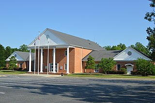
New Kent County is a county in the south eastern part the Commonwealth of Virginia. As of the 2020 United States Census, its population was 22,945. Its county seat is New Kent.

Charles City County is a county located in the U.S. commonwealth of Virginia. The county is situated southeast of Richmond and west of Jamestown. It is bounded on the south by the James River and on the east by the Chickahominy River.
Mechanicsville is an unincorporated community and census-designated place (CDP) in Hanover County, Virginia, United States. The population was 39,482 during the 2020 census, up from 36,348 in the 2010 census.

Powhatan, whose proper name was Wahunsenacawh, was the leader of the Powhatan, an alliance of Algonquian-speaking Native Americans living in Tsenacommacah, in the Tidewater region of Virginia at the time when English settlers landed at Jamestown in 1607.

Toano, formerly Burnt Ordinary, is an unincorporated community in James City County, Virginia, United States. It is in Virginia’s 1st Congressional District.

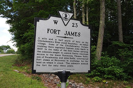
Providence Forge is an unincorporated community in New Kent County, Virginia, United States. It was one of the earliest settlements in the county and the site of a colonial iron forge that was destroyed by British General Banastre Tarleton during the American Revolutionary War.

Fort Pocahontas was an earthen fort on the north bank of the James River at Wilson's Wharf, in Charles City County, Virginia which served as a Union supply depot during the American Civil War. The fort was constructed by African-American soldiers of the United States Colored Troops under the command of Brig. Gen. Edward Augustus Wild.

Historic Jamestown is the cultural heritage site that was the location of the 1607 James Fort and the later 17th-century town of Jamestown in America. It is located on Jamestown Island, on the James River at Jamestown, Virginia and operated as a partnership between Preservation Virginia and the U.S. National Park Service as part of Colonial National Historical Park.
Werowocomoco was a village that served as the headquarters of Chief Powhatan, a Virginia Algonquian political and spiritual leader when the English founded Jamestown in 1607. The name Werowocomoco comes from the Powhatan werowans (weroance), meaning "leader" in English; and komakah (-comoco), "settlement". The town was documented by English settlers in 1608 as located near the north bank of the York River in what is now Gloucester County. It was separated by that river and the narrow Virginia Peninsula from the English settlement of Jamestown, located on the James River.

Palmyra is a census-designated place (CDP) in and the county seat of Fluvanna County, Virginia, United States. The population as of the 2010 census was 104. Palmyra lies on the eastern bank of the Rivanna River along U.S. Route 15. The ZIP code for Palmyra and surrounding rural land is 22963.

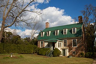
Piney Grove at Southall's Plantation is a property listed on the National Register of Historic Places in Holdcroft, Charles City County, Virginia. The scale and character of the collection of domestic architecture at this site recalls the vernacular architectural traditions of the eighteenth, nineteenth and twentieth centuries along the James River.

The Abbott Farm Historic District is a National Historic Landmark archaeological site in New Jersey. It is the largest known Middle Woodland village of its type on the East Coast of the United States. Significant evidence suggests that the Delaware River floodplain was occupied by Paleoindian people for a long period. It was inhabited between 500 BC and 500 AD. It has been a source of controversy and debate around early development.

Minisink Archeological Site, also known as Minisink Historic District, is an archeological site of 1320 acres located in both Sussex County, New Jersey and Pike County, Pennsylvania. It was part of a region occupied by Munsee-speaking Lenape that extended from southern New York across northern New Jersey to northeastern Pennsylvania. The Munsee were speakers of one of the three major language dialects of the Lenape Native American tribe. This interstate territory became the most important Munsee community for the majority of the 17th and 18th centuries.

St. John's is an Episcopal church located in Hampton, Virginia, United States, within the Episcopal Diocese of Southern Virginia. Established in 1610, St. John's is the oldest English-speaking parish in continuous existence in the United States of America.
Tree Hill near Richmond, Virginia, in Henrico County, Virginia, is a Greek Revival style plantation house overlooking the James River about two miles east of downtown Richmond near the intersection of the historic Osborne Turnpike and New Market Road. Currently still a private farm, but expected to become partly a park after housing and commercial development, it was once owned by Richmond distiller and landowner Franklin Stearns, a prominent Unionist during the American Civil War. Centuries earlier, it had been a Native American camp site, and the birthplace of powerful chief Powhatan (d.1618).

Windsor Shades is located on the Pamunkey River in Sweet Hall, Virginia, United States. It is listed on the National Register of Historic Places. Archeological native artifacts found on the property surrounding the house suggest it was the site of Kupkipcok, a Pamunkey village noted on John Smith's 1609 map.

Conestoga Town is an historic archaeological site memorializing the Native American tribal village which stood on the site from the late 17th into the mid-18th-century; it is located at what is now Manor Township in Lancaster County, Pennsylvania. The town is a settlement at the southern end of the once vast range of the Susquehannock nation or Conestoga Indian nation, which once extended from the northern reaches of Maryland to the along the southern width of southern New York State and southern Catskills where a related people, the Five Nations of the Iroquois Confederacy held western settlement in check for 200 years. Their territory encompassed the entire drainage basin of the Susquehanna River which shares the tribe's root name and extended to the drainage divides of the flanking mountains both to the East to the Delaware nation and to the West to Shawnee lands. The town is the earliest established known surviving settlement of the tribe, and it is known that William Penn himself visited to negotiate with the tribal leaders. The site is also one known to be among the last occupied of the Susquehannock town sites in Pennsylvania as they faded into obscurity.

Kentland Farm Historic and Archeological District is a historic home, archaeological site, and national historic district located near Blacksburg, Montgomery County, Virginia. The district encompasses a complex of 19th century agricultural outbuildings associated with a Federal and Greek Revival style brick dwelling built 1834–1835. Located in the district are significant archaeological resources that include a complex of Late Woodland village or camp sites.
The Chickahominy Shipyard Archeological Site is a historic archaeological site located near Toano, Virginia. The shipyard was established in 1776 on the Chickahominy River by the Virginia Committee on Safety for the construction of a small navy to protect the Virginia colony during the American Revolution. It remained in production until 1781, when the British seized and burned the shipyard. The site consists of both submerged and dryland components.

 Virginia historical marker
