Cityplace, Dallas

Last updated

Cityplace
Uptown Dallas.jpg
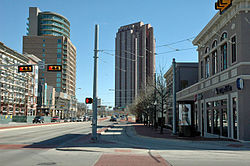
West Village, Mondrian and Tower at Cityplace
Cityplace, Dallas
Country United States
State Texas
County Dallas
City Dallas
Area
  Water0 sq mi (0 km2)  0%
Area codes 214, 469, 972

Cityplace is a TIF District and neighborhood in Old East Dallas, Dallas, Texas, United States, near the Uptown neighborhood and adjacent to the intersection of Central Expressway and Haskell Avenue/Blackburn Street. East of Central Expressway, the neighborhood includes the tree-lined Haskell Boulevard and travels past the 42-story Cityplace Tower, the tallest building in Dallas outside of Downtown. The west side of Cityplace includes the new-urbanist West Village and the northern end of the Uptown neighborhood.

Contents

Tallest structures

Measuring by structural height, the tallest buildings in the Cityplace neighborhood are:

  1. Cityplace Tower, 560 feet (171 m)
  2. The Mondrian, 263 feet (80 m)

Economy

On June 8, 2009, Dean Foods announced plans to move to the Tower at Cityplace in the first quarter of 2010. [1]

Attractions

Education

Public (DISD)

High schools

Middle schools

  • Rusk Middle School
  • Alex W. Spence Middle School

Elementary schools

  • Houston Elementary School

Private Schools

  • Holy Trinity Catholic School

Transportation

Streetcars

The M-Line Trolley is a heritage streetcar that provides service between Cityplace/Uptown station in Uptown and St Paul station in Downtown. Service is free.
The M-Line features 40 dedicated stops serving key destinations including: the West Village, McKinney Avenue, Klyde Warren Park, the Dallas Arts District, four historical cemeteries, and the State Thomas historic neighborhood.

Light rail

References

  1. Hethcock, Bill. "Dean Foods to relocate corporate office." Dallas Business Journal . Monday June 8, 2009. Retrieved on August 2, 2009.

32°48′25″N96°47′35″W / 32.807°N 96.793°W / 32.807; -96.793