
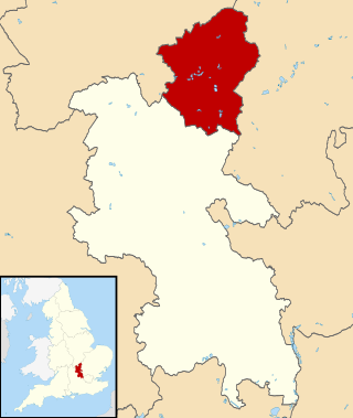
South Yorkshire is a ceremonial county in the Yorkshire and the Humber region of England. It borders North Yorkshire and West Yorkshire to the north, the East Riding of Yorkshire to the north-east, Lincolnshire to the east, Nottinghamshire to the south-east, and Derbyshire to the south and west. The largest settlement is the city of Sheffield.

Doncaster is a city in South Yorkshire, England. Named after the River Don, it is the administrative centre of the City of Doncaster metropolitan borough, and is the second largest settlement in South Yorkshire after Sheffield. Noted for its racing and railway history, it is situated in the Don Valley on the western edge of the Humberhead Levels and east of the Pennines. The built up area had a population of 87,455 at the 2021 census, whilst the wider metropolitan borough had a population of 308,100.
The City of Milton Keynes is a unitary authority area with both borough and city status, in Buckinghamshire. It is the northernmost district of the South East England Region. The borough abuts Bedfordshire, Northamptonshire and the remainder of Buckinghamshire.

Bassetlaw is a local government district in north Nottinghamshire, England. Its council is based in the town of Worksop; the other towns in the district are Retford, Tuxford and Harworth Bircotes. The district also contains numerous villages and surrounding rural areas.

Selby District was a local government district of North Yorkshire, England, from 1974 to 2023. Its council was based in the town of Selby. The district had a population of 83,449 at the 2011 Census. The southernmost district of North Yorkshire, it bordered the City of York unitary authority, the Borough of Harrogate in North Yorkshire, the City of Leeds and City of Wakefield districts in West Yorkshire, the City of Doncaster in South Yorkshire, and the ceremonial county of the East Riding of Yorkshire.
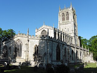
Tickhill is a market town and civil parish in the City of Doncaster, South Yorkshire, England, close to the border with Nottinghamshire. At the 2001 census it had a population of 5,301, reducing to 5,228 at the 2011 Census.

The Metropolitan Borough of Rotherham is a metropolitan borough of South Yorkshire, England. It is named after its main settlement of Rotherham. The wider borough spans a larger area and covers the outlying towns of Maltby, Swinton, Wath-upon-Dearne, Dinnington. As well as the villages of Rawmarsh and Laughton. A large valley spans the entire borough and is referred to as the "Rother Valley".

The City of Doncaster is a metropolitan borough with city status in South Yorkshire, England. It is named after its principal settlement, Doncaster, and includes the surrounding suburbs of Doncaster as well as numerous towns and villages. The district has large amounts of countryside; at 219 square miles (570 km2), it is the largest metropolitan borough in England by area.

Austerfield is a village and civil parish in the City of Doncaster, South Yorkshire, England. It is 1 mile (1.6 km) to the north-east of the market town of Bawtry on the A614 road, and adjacent to the hamlet of Newington in Nottinghamshire, close to the River Idle. The population in 2001 was 571, which fell to 536 at the 2011 Census.

Clayton is a village in the west of the City of Doncaster, South Yorkshire, England, on the border with West Yorkshire. It lies to the north of Thurnscoe at an elevation of around 80 metres above sea level.

A civil parish is a country subdivision, forming the lowest unit of local government in England. There are 94 civil parishes in the ceremonial county of South Yorkshire, most of the county being unparished. At the 2001 census, there were 360,191 people living in the parishes, increasing to 369,220 in 2011, accounting for 27.5 per cent of the county's population.
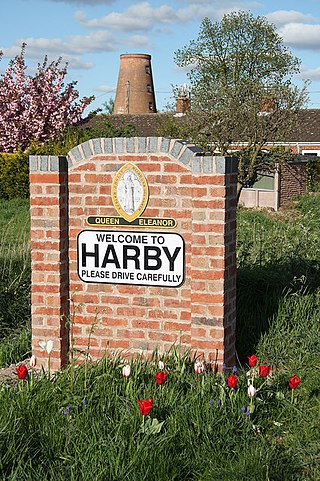
Harby is a village and civil parish in the Newark and Sherwood district of Nottinghamshire, England. It is close to Doddington, Lincolnshire, and is the easternmost settlement in Nottinghamshire, the boundary separating the two. According to the 2011 census, it had a population of 336, up from 289 at the 2001 census. It increased to 346 at the 2021 census.
Barwick in Elmet and Scholes is a civil parish in the City of Leeds metropolitan borough in West Yorkshire, England. According to the 2001 census it had a population of 5,120, decreasing to 4,902 at the 2011 Census. The parish includes Barwick-in-Elmet and Scholes, situated in the north-eastern part of the borough.
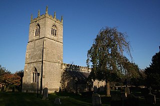
Braithwell is a village and civil parish in the Metropolitan Borough of Doncaster in South Yorkshire, England. It is about 1 mile (1.6 km) north from Maltby and 3 miles (5 km) south-east from Conisbrough. According to the 2001 Census the civil parish had a population of 1,056, increasing slightly to 1,060 at the 2011 Census.
Brodsworth is a village and civil parish in the City of Doncaster district in South Yorkshire, England. Situated about five miles north-west of Doncaster city centre, the parish also includes Scawsby. According to the 2001 census, it had a population of 2,875, increasing to 2,936 at the 2011 Census.
Shadwell is a village and civil parish in north-east Leeds, West Yorkshire, England. The village is 6 miles (9.7 km) to the north east of Leeds city centre.

Hook is a village and civil parish in the East Riding of Yorkshire, England. It is situated approximately 1.5 miles (2.4 km) north-east of Goole town centre and lies on the west bank of the River Ouse.

Thorpe in Balne is a village and civil parish in the Metropolitan Borough of Doncaster in South Yorkshire, England. It had a population of 176 at the 2001 census, increasing to 203 at the 2011 Census.
Conisbrough Parks is a civil parish in the Metropolitan Borough of Doncaster and ceremonial county of South Yorkshire in England. It had a population of 385 at the 2001 Census, reducing to 374 at the 2011 Census.

