
The Arctic Archipelago, also known as the Canadian Arctic Archipelago, is a group of islands north of the Canadian mainland.

Drygalski Island is an ice-capped island that is 20.4 kilometres (11 nmi) long and rises to 325 m (1,066 ft) in the Davis Sea of the Southern Ocean, about 85 km (53 mi) north of the coast of Queen Mary Land and 45 km (28 mi) north-northeast of Cape Filchner. The island has an area of 220 km2 (85 sq mi).
Scullin Monolith is a crescent-shaped rock fronting the sea 6 km (3.7 mi) west of the similar Murray Monolith, and 8 km (5.0 mi) from Torlyn Mountain, in Mac. Robertson Land, Antarctica. Early in January 1930 the British Australian New Zealand Antarctic Research Expedition (BANZARE) under Douglas Mawson made an aerial flight from the ship over the area. Mawson set foot on the rock on 13 February 1931 and named it for James Scullin, Prime Minister of Australia in 1929 - 31. The rock was charted in January and February 1931 from Norwegian whale catchers exploring the coast, and named "Mount Klarius Mikkelsen" for Captain Klarius Mikkelsen, master of the whale catcher Torlyn. Mikkelsen Peak is retained as the name of the highest peak of the outcrop.
Holme Bay is a bay in Antarctica in Mac. Robertson Land, 22 miles (35 km) wide, containing many islands, indenting the coast 5 miles (8 km) north of the Framnes Mountains. Holme Bay is largely snow-free and was mapped by Norwegian cartographers from aerial photographs taken by the Lars Christensen Expedition in January-February 1937, and named Holmevika because of its island-studded character.

Seaton Glacier is a glacier 17 miles (27 km) long, flowing southeast into Edward VIII Ice Shelf at the northwest part of Edward VIII Bay. It was mapped by Norwegian cartographers from aerial photos taken by the Lars Christensen Expedition, 1936–37, remapped, 1954–58, by ANARE and named by ANCA in 1958 for Flight Lt. John Seaton, RAAF, pilot with ANARE at Mawson in 1956.
The Scott Mountains are a large number of isolated peaks lying south of Amundsen Bay in Enderby Land of East Antarctica, Antarctica. Discovered on 13 January 1930 by the British Australian New Zealand Antarctic Research Expedition (BANZARE) under Sir Douglas Mawson. He named the feature Scott Range after Captain Robert Falcon Scott, Royal Navy. The term mountains is considered more appropriate because of the isolation of its individual features.
Sheehan Islands is a group of small islands lying at the southeast side of Islay in the William Scoresby Archipelago. Discovered on February 18, 1931, by the British Australian New Zealand Antarctic Research Expedition (BANZARE) under Mawson. He named one of the group Sheehan Nunatak after Sir Harry Sheehan, Asst. Secretary to the Treasury, who was Secretary of the Australian Antarctic Committee of BANZARE. BANZARE erroneously charted Sheehan Nunatak as lying behind the coastline. The insularity of the group was determined by Discovery Investigations personnel on the RSS William Scoresby on February 27, 1936. The islands were more fully mapped by Norwegian cartographers from aerial photographs taken by the Lars Christensen Expedition in January and February 1937.
Robinson Group is a group of small islands extending 16 km (10 mi) in an east-west direction, lying close northwest of Cape Daly. The group was observed by British Australian New Zealand Antarctic Research Expedition (BANZARE) under Mawson, 1931, who named it after W.S. Robinson of Melbourne, a patron of the expedition. Essentially the same islands were observed in 1931 by the crew of the Norwegian whale catcher Thorgaut, who gave them the name "Thorgautoyane". In concurrence with the recommendations by Antarctic Names Committee of Australia (ANCA), the name "Robinson" has been assigned to the whole group and the name "Thorgaut" to the most conspicuous island.
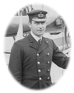
William Colbeck was a British seaman who distinguished himself on two Antarctic expeditions.
Cape Bruce forms the northern tip of a small island lying at the eastern side of Oom Bay, separated from the mainland rocks just west of Taylor Glacier in Mac. Robertson Land, Antarctica.
Oom Bay is a well-defined bay, 2 mi wide, indenting the Mawson coast between Cape Bruce and Campbell Head. Discovered in February 1931 by the British Australian and New Zealand Antarctic Research Expedition (BANZARE) under Douglas Mawson, who named it for Lieutenant K.E. Oom, RAN, cartographer with the expedition.
Chapman Ridge is a ridge rising to 300 metres (1,000 ft) and extending southwest for 3 nautical miles (6 km) from Byrd Head. It was discovered by the British Australian New Zealand Antarctic Research Expedition, 1929–31, under Douglas Mawson, and mapped by Norwegian cartographers from aerial photographs taken by the Lars Christensen Expedition, 1936–37. It was named by the Antarctic Names Committee of Australia for the then-Australian scientist, Philip K. Chapman, auroral physicist at Mawson Station, during the International Geophysical Year,1958. Chapman and Henry Fischer, a Swiss national, were members of the Australian National Antarctic Research Expedition (ANARE). They were the first humans to climb the ridge which they did several times. They did not take geological samples, make claims nor leave any marker.
Mount Christensen is a prominent ice-covered mountain, 1,475 metres (4,840 ft) high, at the southwest side of Rayner Glacier in Enderby Land. It was discovered on 13 January 1930 by the British Australian New Zealand Antarctic Research Expedition under Mawson, who named it for Consul Lars Christensen, Norwegian whaling magnate and promoter of several Norwegian Antarctic expeditions.
Watson Nunatak is a nunatak standing between Price and Van Hulssen Nunataks in the Trilling Peaks, Framnes Mountains, in Mac. Robertson Land. Mapped by Norwegian cartographers from air photos taken by the Lars Christensen Expedition, 1936-37. Named by Antarctic Names Committee of Australia (ANCA) for K.D. Watson, diesel mechanic at Mawson Station, who assisted in the Framnes Mountains--Depot Peak survey by ANARE in 1965.
Stevenson Island is a small island 120 m high, lying at the east side of Colbeck Archipelago, 2 nautical miles (3.7 km) northeast of Cape Simpson. Discovered in February 1931 by the British Australian New Zealand Antarctic Research Expedition (BANZARE) under Mawson. He named it for Captain J.B. Stevenson, Royal Navy, a member of the Australian Aurora Committee, 1916-17.
Grinder Rock is the southernmost of a group of rocks extending from the southeast end of Intercurrence Island, in the Palmer Archipelago, Antarctica. It was shown on Argentine and Chilean government charts of 1957. The name, given by the UK Antarctic Place-Names Committee in 1960, is descriptive of this toothlike feature.
Mill Peak is a prominent peak, 1,760 metres (5,770 ft) high, rising above the Antarctic ice sheet 10 nautical miles (19 km) south of Pearce Peak and 30 nautical miles (56 km) south of Cape Simpson. it was discovered in February 1931 by the British Australian New Zealand Antarctic Research Expedition under Douglas Mawson, who named it for Dr. Hugh Robert Mill.
Teksla Island is a largest island in the Colbeck Archipelago near the coast of Mac. Robertson Land, 1 nautical mile (1.9 km) north of Chapman Ridge. Mapped by Norwegian cartographers from aerial photographs taken by the Lars Christensen Expedition, 1936–37, and named Teksla.
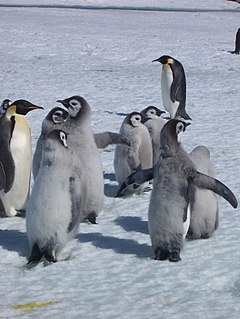
Taylor Rookery is an emperor penguin breeding colony on the Mawson Coast of Mac.Robertson Land in East Antarctica. It is the larger of the two known entirely land-based colonies of the species, most of which are situated on sea ice.


