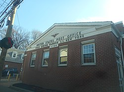
Cold Spring Harbor, New York | |
---|---|
Coordinates: 40°52′N73°27′W / 40.867°N 73.450°W | |
Country | United States |
State | New York |
County | Suffolk |
Town | Huntington |
Area | |
• Total | 3.58 sq mi (9.28 km2) |
• Land | 3.41 sq mi (8.84 km2) |
• Water | 0.17 sq mi (0.44 km2) |
Elevation | 33 ft (10 m) |
Population (2020) | |
• Total | 3,064 |
• Density | 898.01/sq mi (346.70/km2) |
Time zone | UTC-5 (Eastern (EST)) |
• Summer (DST) | UTC-4 (EDT) |
ZIP code(s) | 11724, 11743 [2] |
Area code(s) | 631, 934 |
FIPS code | 36-16958 |
GNIS feature ID | 0947073 |
Website | www |
Cold Spring Harbor is a hamlet and census-designated place (CDP) in the Town of Huntington, in Suffolk County, on the North Shore of Long Island in New York. As of the 2010 United States census, the CDP population was 5,070. [3]
Cold Spring Harbor was named after the naturally cold freshwater springs that flow in the area. Its economy mainly tied to milling and port activities, it rose in prominence as a whaling community in the mid-nineteenth century. After the decline of whaling in the 1860s, it became a resort town with several hotels. In the 20th century it became known as the site of Cold Spring Harbor Laboratory, although the laboratory itself is located in the adjacent village of Laurel Hollow in Nassau County, which was called Cold Spring before incorporation.
Today it is primarily a bedroom community of New York City, with a small central business area running along Route 25A, and is home to many educational and cultural organizations: the Cold Spring Harbor Whaling Museum, the Cold Spring Harbor Fish Hatchery and Aquarium (also in Laurel Hollow), Dolan DNA Learning Center, the Uplands Farm Sanctuary (home of The Nature Conservancy's Long Island chapter), and a museum exhibition gallery run by Preservation Long Island.
According to the United States Census Bureau, the CDP has a total area of 3.9 square miles (10 km2), of which 3.7 square miles (9.6 km2) is land and 0.2 square miles (0.52 km2), or 4.86%, is water. [4]
Census | Pop. | Note | %± |
---|---|---|---|
2000 | 4,975 | — | |
2010 | 5,070 | 1.9% | |
2020 | 3,064 | −39.6% | |
U.S. Decennial Census [5] |
As of the census [6] of 2000, there were 4,975 people, 1,753 households, and 1,416 families residing in the CDP. The population density was 1,336.3 inhabitants per square mile (515.9/km2). There were 1,790 housing units at an average density of 480.8 per square mile (185.6/km2). The racial makeup of the CDP was 97.03% White, 0.42% African American, 0.02% Native American, 1.31% Asian, 0.24% from other races, and 0.98% from two or more races. Hispanic or Latino of any race were 1.97% of the population.
There were 1,753 households, out of which 38.8% had children under the age of 18 living with them, 71.8% were married couples living together, 7.1% had a female householder with no husband present, and 19.2% were non-families. 14.9% of all households were made up of individuals, and 5.8% had someone living alone who was 65 years of age or older. The average household size was 2.84 and the average family size was 3.15.
In the CDP, the population was spread out, with 26.7% under the age of 18, 4.2% from 18 to 24, 28.9% from 25 to 44, 26.9% from 45 to 64, and 13.4% who were 65 years of age or older. The median age was 40 years. For every 100 females, there were 94.9 males. For every 100 females age 18 and over, there were 92.1 males.
The median income for a household in the CDP was $101,122, and the median income for a family was $112,441. Males had a median income of $78,984 versus $44,464 for females. The per capita income for the CDP was $52,403. About 1.3% of families and 2.2% of the population were below the poverty line, including 0.4% of those under age 18 and 3.6% of those age 65 or over.
Residents of Cold Spring Harbor fall into one of two library districts, Cold Spring Harbor and Huntington, each of which correspond to their respective school district. [7] [2]
Cold Spring Harbor State Park is located here.
Cold Spring Harbor is primarily served by the Cold Spring Harbor School District, and in parts by the Huntington Union Free School District. [2]
Cold Spring Harbor is served by the Cold Spring Harbor LIRR Station which is outside the hamlet in the neighboring hamlet of West Hills.
Baldwin Harbor is a hamlet and former census-designated place (CDP) in the Town of Hempstead, in Nassau County, on Long Island, in New York, United States. It was created concomitant with the 1990 United States Census from the southernmost portions of the neighboring hamlet of Baldwin. As of the 2010 census, it had a population of 8,102.
Bellerose Terrace is a hamlet and census-designated place (CDP) in the Town of Hempstead in Nassau County, on Long Island, in New York, United States. The population was 2,329 at the 2020 census.
Garden City Park is a hamlet and census-designated place (CDP) located in the Town of North Hempstead in Nassau County, New York, on Long Island. It's a suburb of New York City, located approximately 20 miles (32 km) from Midtown Manhattan. The population was 7,806 at the 2010 census.
Harbor Hills is a hamlet and census-designated place (CDP) located on the Great Neck Peninsula within the Town of North Hempstead in Nassau County, on the North Shore of Long Island, in New York, United States. The population was 562 at the time of the 2020 census.
Laurel Hollow is a village in the Town of Oyster Bay in Nassau County, on the North Shore of Long Island, in New York, United States. The population was 1,952 at the 2010 census. According to Bloomberg BusinessWeek, Laurel Hollow was the eighth wealthiest town in America.
Syosset is a hamlet and census-designated place in the Town of Oyster Bay, in Nassau County, on the North Shore of Long Island, in New York, United States. The population was 19,259 at the time of the 2020 census.
Woodbury is a hamlet and census-designated place (CDP) located within the Town of Oyster Bay in Nassau County, on Long Island, in New York, United States. The population was 9,335 at the 2020 census.
Bridgehampton is a hamlet and census-designated place (CDP) on the South Fork of Suffolk County, New York, United States. The population was 1,756 at the 2010 census.
Centerport is a hamlet and census-designated place (CDP) in Suffolk County, New York, United States, on the notably affluent North Shore of Long Island, historically known as the Gold Coast. Formerly known as Little Cow Harbor in about 1700, as Centerport in 1836, and as Centerport after 1895, the name refers to its geographic position midway between the east and west boundaries of the town of Huntington.
East Northport is a hamlet and census-designated place (CDP) in the town of Huntington in Suffolk County, New York, United States. The population was 20,217 at the 2010 census.
Eatons Neck is a hamlet and census-designated place (CDP) in the Town of Huntington in Suffolk County, on the North Shore of Long Island, in New York, United States. The population was 1,406 at the 2010 census.
Fort Salonga is a hamlet and census-designated place (CDP) in the Towns of Huntington and Smithtown in Suffolk County, on the North Shore of Long Island, in New York, United States. The population was 10,008 at the 2010 census.
Greenlawn is a hamlet and census-designated place (CDP) in Suffolk County, New York, United States. Located on Long Island in the Town of Huntington, the population was 13,742 at the 2010 census. Students primarily attend the Harborfields Central School District.
Halesite is a hamlet and census-designated place (CDP) in the Town of Huntington in Suffolk County, on the North Shore of Long Island, in New York, United States. The population was 2,498 at the 2010 census.
Melville is an affluent hamlet and census-designated place (CDP) in the Town of Huntington in Suffolk County, on Long Island, in New York, United States. The population was 19,284 at the time of the 2020 census.
North Amityville is a hamlet and census-designated place (CDP) in the Town of Babylon in Suffolk County, on the South Shore of Long Island, in New York. The population was 18,643 at the 2020 Census.
Northwest Harbor is a hamlet and census-designated place (CDP) in the Town of East Hampton, Suffolk County, New York, United States. The population was 3,317 at the 2010 census.
Wading River is a hamlet and census-designated place (CDP) in Suffolk County, New York, United States, on the North Shore of Long Island. As of the 2010 census, the CDP population was 7,719. It is adjacent to Shoreham and shares a school district.
Riverhead is a census-designated place (CDP) roughly corresponding to the hamlet by the same name located in the Town of Riverhead in Suffolk County, on Long Island, in New York, United States. The CDP's population was 13,299 at the 2010 census.
Huntington is a hamlet and census-designated place (CDP) located within the Town of Huntington in Suffolk County, on the North Shore of Long Island, in New York, United States. The population was 18,406 at the 2010 census. The hamlet serves as the Town Seat of the Town of Huntington.