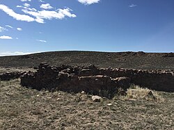
Ruins of the Cold Springs Pony Express station built in 1860
Cold Springs, less commonly known as Rock Creek, was established as a station along the Pony Express express mail route in March 1860. In 1861, a repeater which would eventually serve the first transcontinental telegraph was built about 1.5mi (2.4km) northwest of the Pony Express station. Later that year in July, a new station serving the Overland Trail commercial and passenger stage line opened just south of the telegraph station, replacing the original Cold Springs station which had been pillaged by Native Americans in May 1860 amidst the Paiute War.[2][3]
Currently, the area just northeast of the stagecoach stations is the site of the Cold Springs Station Resort with a restaurant, bar, gift shop, and lodging accommodations, including a six-room motel, three cabins, and an RV park.[6] The rest of the community of Cold Springs consists of residences and a Nevada Department of Transportation maintenance depot.
This page is based on this Wikipedia article Text is available under the CC BY-SA 4.0 license; additional terms may apply. Images, videos and audio are available under their respective licenses.