Collinwood Township, Meeker County, Minnesota

Last updated

Collinwood Township, Minnesota
District No. 48 School.jpg
Collinwood Town Hall, built as a schoolhouse in 1870
USA Minnesota location map.svg
Red pog.svg
Collinwood Township, Minnesota
Location within the state of Minnesota
Usa edcp location map.svg
Red pog.svg
Collinwood Township, Minnesota
Collinwood Township, Minnesota (the United States)
Coordinates: 45°1′N94°19′W / 45.017°N 94.317°W / 45.017; -94.317
Country United States
State Minnesota
County Meeker
Area
  Total36.1 sq mi (93.4 km2)
  Land31.0 sq mi (80.4 km2)
  Water5.0 sq mi (13.0 km2)
Elevation
1,125 ft (343 m)
Population
 (2000)
  Total1,037
  Density33.4/sq mi (12.9/km2)
Time zone UTC-6 (Central (CST))
  Summer (DST) UTC-5 (CDT)
FIPS code 27-12628 [1]
GNIS feature ID0663849 [2]

Collinwood Township is a township in Meeker County, Minnesota, United States. The population was 1,037 at the 2000 census.

Contents

History

Collinwood Township was named after Collinwood, Canada, where the first settlers in the area came from. There is also a Collinwood Lake nearby. For a few years, the township was known as New Virginia (the 1870 U.S. Census lists it as such). In May of 1866, the first settlers came. They were Oliver Rasnick, Henry Fuller, George Fuller, and Jacob, Nancy, and Thomas Hutchins. The town was organized on May 8, 1866. The first Justice of the Peace was Oliver Rasnick. The first death was the child of E. K. and Jane Counts, who were from Virginia. In 1857, John Taylor and Elizabeth Hutchins were the first couple to be married there. Also that year, Alexander Ramsey married Margaret Hutchins. The population was 1,037 in the 2000 census.

Geography

According to the United States Census Bureau, the township has a total area of 36.1 square miles (93 km2), of which 31.0 square miles (80 km2) is land and 5.0 square miles (13 km2) (13.92%) is water.

Collinwood Township is located in Township 118 North of the Arkansas Base Line and Range 29 West of the 5th Principal Meridian.

Demographics

As of the census [1] of 2000, there were 1,037 people, 364 households, and 289 families residing in the township. The population density was 33.4 inhabitants per square mile (12.9/km2). There were 462 housing units at an average density of 14.9 per square mile (5.8/km2). The racial makeup of the township was 99.32% White, 0.10% Asian, 0.19% from other races, and 0.39% from two or more races. Hispanic or Latino of any race were 0.77% of the population.

There were 364 households, out of which 36.3% had children under the age of 18 living with them, 73.9% were married couples living together, 2.5% had a female householder with no husband present, and 20.6% were non-families. 16.2% of all households were made up of individuals, and 5.8% had someone living alone who was 65 years of age or older. The average household size was 2.85 and the average family size was 3.16.

In the township the population was spread out, with 28.0% under the age of 18, 5.4% from 18 to 24, 25.6% from 25 to 44, 27.9% from 45 to 64, and 13.2% who were 65 years of age or older. The median age was 40 years. For every 100 females, there were 114.3 males. For every 100 females age 18 and over, there were 113.4 males.

The median income for a household in the township was $56,786, and the median income for a family was $63,295. Males had a median income of $41,200 versus $30,000 for females. The per capita income for the township was $22,065. About 4.1% of families and 6.2% of the population were below the poverty line, including 11.6% of those under age 18 and 1.6% of those age 65 or over.

Steelesville

Located within the township is an area known as Steelesville. The community of Steelesville was first delineated by the school district of the same name. The school was a typical rural America one-room school building occupied by students in grades one through eight who resided in the confines of the Steelesville School district. Also located within the Steelesville community is the Steelesville Cemetery. The Steelesville Cemetery is a one-acre active cemetery, owned by Gethsemane Lutheran Church, Dassel, Minnesota, and maintained by the Steelesville Cemetery Association.

Related Research Articles

<span class="mw-page-title-main">Seney Township, Michigan</span> Civil township in Michigan, United States

Seney Township is a civil township of Schoolcraft County in the U.S. state of Michigan. As of 2020, its population was 115. With a population density of only 0.560/sq mi (0.216/km2), Seney Township is the second least-densely populated municipality in the state after West Branch Township.

Lake Eunice Township is a township in Becker County, Minnesota, United States. The population was 1,538 as of the 2010 census.

Spring Prairie Township is a township in Clay County, Minnesota, United States. As of the 2020 census, the population was 506, up from 368 at the previous census.

Pilot Mound Township is a township in Fillmore County, Minnesota, United States. The population was 364 at the 2000 census.

South Harbor Township is a township in Mille Lacs County, Minnesota, United States. The population was 800 at the 2010 census.

Belfast Township is a township in Murray County, Minnesota, United States. The population was 195 at the 2000 census.

Bondin Township is a township in Murray County, Minnesota, United States. The population was 335 at the 2000 census.

<span class="mw-page-title-main">Fullerton, Nebraska</span> City in and county seat of Nance County, Nebraska, United States

Fullerton is a city in, and the county seat of, Nance County, Nebraska, United States. Its population was 1,307 as of the 2010 Census.

<span class="mw-page-title-main">Burrell Township, Armstrong County, Pennsylvania</span> Township in Pennsylvania, United States

Burrell Township is a township in Armstrong County, Pennsylvania, United States, and is part of the Pittsburgh metropolitan area. The population was 659 at the 2020 census, a decrease from the figure of 689 tabulated in 2010.

<span class="mw-page-title-main">Kittanning Township, Armstrong County, Pennsylvania</span> Township in Pennsylvania, United States

Kittanning Township is a township in Armstrong County, Pennsylvania, United States. The population was 2,019 at the 2020 census, a decrease from the figure of 2,265 tabulated in 2010.

<span class="mw-page-title-main">Terry Township, Pennsylvania</span> Township in Pennsylvania, United States

Terry Township is a township in Bradford County, Pennsylvania. The population was 992 at the 2010 census.

<span class="mw-page-title-main">West Taylor Township, Pennsylvania</span> Township in Pennsylvania, United States

West Taylor Township is a township that is located in Cambria County, Pennsylvania, United States. The population was 795 at the time of the 2010 census.

<span class="mw-page-title-main">Liverpool Township, Perry County, Pennsylvania</span> Township in Pennsylvania, United States

Liverpool Township is a township in Perry County, Pennsylvania, United States. The population was 1,037 at the 2020 census. It is not to be confused with the borough of Liverpool, which is adjacent.

<span class="mw-page-title-main">Reinerton-Orwin-Muir, Pennsylvania</span> Former CDP in Pennsylvania, United States

Reinerton-Orwin-Muir was a census-designated place (CDP) that was located in Schuylkill County, Pennsylvania, United States. The population was 1,037 at the time of the 2000 census. For the 2010 census, the area was split into three CDPs, Reinerton, Orwin, and Muir.

<span class="mw-page-title-main">Black Township, Pennsylvania</span> Township in Pennsylvania, United States

Black Township is a township in Somerset County, Pennsylvania, United States. The population was 899 at the 2020 census. It is part of the Johnstown, Pennsylvania, Metropolitan Statistical Area. The township was named for Jeremiah Sullivan Black, a native of Somerset County who became Chief Justice of the Supreme Court of Pennsylvania, U.S. Attorney General, and U.S Secretary of State.

<span class="mw-page-title-main">Liberty Township, Tioga County, Pennsylvania</span> Township in Pennsylvania, United States

Liberty Township is a township in Tioga County, Pennsylvania, United States. The population was 1,037 at the 2020 census.

<span class="mw-page-title-main">Freehold Township, Warren County, Pennsylvania</span> Township in Pennsylvania, United States

Freehold Township is a township in Warren County, Pennsylvania, United States. The population was 1,214 at the 2020 census, down from 1,510 at the 2010 census.

<span class="mw-page-title-main">Union Township, Washington County, Pennsylvania</span> Township in Pennsylvania, United States

Union Township is a township in Washington County, Pennsylvania, United States. The population was 5,367 at the 2020 census.

North Penobscot is an unorganized territory in Penobscot County, Maine, United States. The population was 405 at the 2020 census.

<span class="mw-page-title-main">Montgomery Township, Crawford County, Illinois</span> Township in Illinois, United States

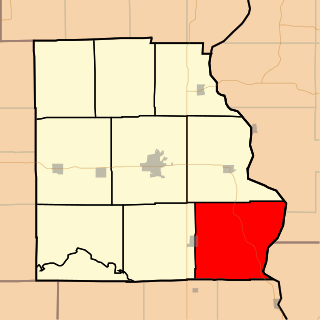
Montgomery Township is one of ten townships in Crawford County, Illinois, USA. As of the 2020 census, its population was 671 and it contained 289 housing units.

References

  1. 1 2 "U.S. Census website". United States Census Bureau . Retrieved January 31, 2008.
  2. "US Board on Geographic Names". United States Geological Survey. October 25, 2007. Retrieved January 31, 2008.