Colne Valley | |
---|---|
Urban district | |
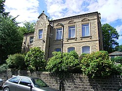
Slaithwaite Town Hall | |
Area | |
6,479 hectares (16,010 acres) | |
Population | |
• 1939 | 22,766 |
• 1961 | 21,298 [1] |
History | |
• Created | 1 April 1937 |
• Abolished | 31 March 1974 |
• Succeeded by | Metropolitan Borough of Kirklees |
• HQ | Slaithwaite |
Contained within | |
• County Council | West Riding |
Map of boundary as of 1960 |
Colne Valley was an urban district in the West Riding of Yorkshire, England between 1937 and 1974. It takes its name from the River Colne which rises above the town of Marsden and flows eastward towards Huddersfield.
Colne Valley Urban District was formed on 1 April 1937 following the abolition of many of the urban districts and reallocation of land surrounding Huddersfield and comprised the following former urban district areas: [2] [1]
Colne Valley UD was abolished under the Local Government Act 1972, becoming part of the Metropolitan Borough of Kirklees on 1 April 1974. No successor parish was created for the area, but its boundaries remain reflected in a ward of the same name on Kirklees Council.
Kirklees is a metropolitan borough of West Yorkshire, England. The borough comprises the ten towns of Batley, Birstall, Cleckheaton, Dewsbury, Heckmondwike, Holmfirth, Huddersfield, Meltham, Mirfield and Slaithwaite. It is governed by Kirklees Council. Kirklees had a population of 422,500 in 2011; it is the third-largest metropolitan district in England by area size, behind Doncaster and Leeds.
Marsden is a large village in the Colne Valley, in the metropolitan borough of Kirklees, West Yorkshire, England. It is in the South Pennines close to the Peak District which lies to the south. The village is 7 miles (11 km) west of Huddersfield at the confluence of the River Colne and Wessenden Brook. It was an important centre for the production of woollen cloth. In 2020, the village had an estimated population of 3,768.
Slaithwaite is a town and former civil parish in the Colne Valley area of the metropolitan borough of Kirklees, in West Yorkshire, England. Historically part of the West Riding of Yorkshire, it lies in the Colne Valley, lying across the River Colne and the Huddersfield Narrow Canal, approximately 5 miles (8 km) south-west of Huddersfield.
Huddersfield is a market town in the Metropolitan Borough of Kirklees in West Yorkshire, England. It is the administrative centre and largest settlement in the Kirklees district. The town is in the foothills of the Pennines. The River Holme's confluence into the similar-sized Colne is to the south of the town centre which then flows into the Calder in the north eastern outskirts of the town.
The Metropolitan Borough of Barnsley is a metropolitan borough in South Yorkshire, England; the main settlement is Barnsley and other notable towns include Penistone, Wombwell and Hoyland.
The Colne Valley is a steep sided valley on the east flank of the Pennine Hills in the English county of West Yorkshire. It takes its name from the River Colne which rises above the town of Marsden and flows eastward towards Huddersfield.
Upperthong is a village approximately 807 feet (246 m) above sea level, near the town of Holmfirth in Holme Valley, approximately 7 miles (11 km) south of Huddersfield, West Yorkshire, England.
Colne Valley is a constituency represented in the House of Commons of the UK Parliament since 2019 by Jason McCartney of the Conservative Party.
The Moorside Edge is a steeply sloping area of moorland at grid reference SE070154 just north of Slaithwaite and about 5 miles (8 km) west of Huddersfield in the Kirklees District of West Yorkshire, England. It descents from the relatively flat summit of Pole Moor into the valley of the River Colne.
Holme Valley, formerly Holmfirth is a large civil parish in the metropolitan borough of Kirklees in West Yorkshire, England. It has a population of 25,049, increasing to 34,680 for the two wards in the 2011 Census. Its administrative centre is in Holmfirth. Other sizeable settlements in the parish include, Brockholes, Honley and New Mill. It is named from the River Holme that runs through the parish.
Spenborough was, from 1915 to 1974, a local government district in the administrative county of Yorkshire, West Riding, England.
Kirkheaton is a village in the parish of Kirkburton, in the Kirklees district of West Yorkshire, England, Historically, it is part of the West Riding of Yorkshire. It is 3 miles (5 km) north-east of Huddersfield, in the Dalton ward of Kirklees Council. In 2021 it had a population of 3,496.
Netherton is a village, near Huddersfield, in the Kirklees metropolitan borough of West Yorkshire, England. It is 2 miles (3 km) south-west of the town centre on the road to Meltham. Netherton together with South Crosland have a population of 3,702 according to the 2001 census.
Thongsbridge is a small village in the Kirklees district of West Yorkshire, England. It is in the semi-rural Holme Valley and the village boundaries merge into the neighbouring communities of Holmfirth, New Mill and Wooldale. According to the 2001 Census, it covers an area of 124.7 hectares.
The Wessenden Valley is a moorland valley in the Dark Peak, immediately south of Marsden in West Yorkshire, England. The name Wessenden derives from Old English and means the 'valley with rock suitable for whetstones'. The valley was formed by retreating glaciers at the end of the last ice age and continues to be cut by the Wessenden Brook a tributary of the River Colne with a catchment of 6.28 square miles (16.27 km2).
Nettleton Hill is a hamlet in the Kirklees district in the English county of West Yorkshire. It is situated west of the town of Huddersfield, north of Scapegoat Hill and south of Pighill Wood. Longwood reservoir is to the east of the settlement. Nettleton Hill is part of the Golcar ward and of the HD7 postcode district.
Baildon was an urban district in the West Riding of Yorkshire, England between 1894 and 1974.
The River Calder is a river in West Yorkshire, in Northern England.
Wilberlee is a hamlet in the Colne Valley, in the Kirklees district, in the county of West Yorkshire, England. It is near the town of Huddersfield and the village of Slaithwaite. Wilberlee has a school called Wilberlee Junior and Infant School.
Slaithwaite Town Hall, also known as Empire House is a former municipal building in Lewisham Road in the town of Slaithwaite, West Yorkshire, England. The building, which served as the offices of Colne Valley Urban District Council, is now a business centre.