State Highway 96 (SH 96) is a state highway in eastern Colorado. Its western terminus is an intersection with SH 69 in Westcliffe. Its eastern terminus is at the Kansas state line, east of Towner, where it continues as K-96.

The San Juan Skyway Scenic and Historic Byway is a 236-mile (380 km) All-American Road, National Forest Scenic Byway, and Colorado Scenic and Historic Byway located in Dolores, La Plata, Montezuma, San Juan, and San Miguel counties, Colorado, United States. The byway forms a loop in southwestern Colorado traversing the heart of the San Juan Mountains. The San Juan Skyway reaches its zenith at Red Mountain Pass at elevation 11,018 feet (3,358 m). Mesa Verde National Park was one of the original UNESCO World Heritage Sites. The Silverton Historic District and the Telluride Historic District are National Historic Landmarks.
The Top of the Rockies National Scenic Byway is a National Scenic Byway and Colorado Scenic and Historic Byway located in the high Rocky Mountains of Eagle, Lake, Pitkin, Summit counties, Colorado, United States. The 115-mile (185 km) byway showcases the two highest peaks of the Rocky Mountains: Mount Elbert at elevation 14,440 feet (4,401.2 m) and Mount Massive at elevation 14,428 feet (4,398 m). The byway connects with the Collegiate Peaks Scenic Byway at the junction of Colorado State Highway 82 and U.S. Highway 24.

State Highway 10 (SH 10) is a 71.968-mile-long (115.821 km) state highway in the US state of Colorado. SH 10's western terminus is at Interstate 25 (I-25) and U.S. Route 160 (US 160) in Walsenburg, and the eastern terminus is at US 50 in La Junta.

State Highway 103 in the U.S. state of Colorado runs from Interstate 70 (I-70), U.S. Route 6 and US 40 at Idaho Springs to county roads 151 and 103 at Mestaa'ėhehe Pass. The 13 miles (19 km) from Idaho Springs to SH 5 forms about half of the Mount Blue Sky Scenic Byway.

State Highway 55 (SH-55) is an Idaho highway from Marsing to New Meadows, connecting with US-95 at both ends.

The Dinosaur Diamond is a 486-mile (782 km) scenic and historic byway loop through the dinosaur fossil laden Uinta Basin of the U.S. states of Utah and Colorado. The byway comprises the following two National Scenic Byways:

State Highway 109 is a 65.327 mi (105.134 km) long state highway in southeastern Colorado. SH 109's southern terminus is at U.S. Route 160 north of Kim, and the northern terminus a continuation north as Grand Avenue in Cheraw.
State Highway 149 (SH 149) is a 117.522-mile-long (189.133 km) state highway in southwestern Colorado, United States. SH 149's southern terminus is at U.S. Highway 160 (US 160) in South Fork, and the northern terminus is at US 50 west of Gunnison. The entire route is also known as the Silver Thread Scenic and Historic Byway.

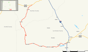
State Highway 165 is a 36.894-mile (59.375 km) state highway in southern Colorado. SH 165's western terminus is at SH 96 east of Silver Cliff, and the eastern terminus is at Interstate 25 (I-25), U.S. Route 85 (US 85) and US 87 near Colorado City.

Cuchara is an unincorporated community in Huerfano County, Colorado, United States. It is located near a former ski resort in the mountains south of the town of La Veta. Its altitude is 8,468 feet (2,581 m). State Highway 12 travels through Cuchara as it approaches Trinidad to the southeast.

State Highway 72 is a 51-mile-long (82 km) state highway passing through the foothills and the eastern edge of the Front Range. Its southern terminus is at Interstate 70 (I-70) in Wheat Ridge, and its northern terminus is at SH 7 east of Allenspark.

State Route 153 (SR-153) is a state highway in the U.S. state of Utah. Just over half of the western portion of the highway has been designated the Beaver Canyon Scenic Byway as part of the Utah Scenic Byways and National Forest Scenic Byways programs.
The Trail of the Ancients is a collection of National Scenic Byways located in the U.S. Four Corners states of Utah, Colorado, New Mexico, and Arizona. These byways comprise:
State Highway 65 (SH 65) is a state highway in Colorado that crosses the Grand Mesa. The highway along with a road to Lands End Overlook were designated as the Grand Mesa National Scenic Byway in 1996. SH 65's southern terminus is at SH 92 east of Delta, and its northern terminus is at Interstate 70 (I-70) and U.S. Route 6 (US 6) northeast of Palisade.

The Enchanted Circle Scenic Byway is a New Mexico Scenic Byway and National Forest Scenic Byway located in Northern New Mexico. It begins and ends in Taos, New Mexico.

U.S. Route 160 (US 160) is a part of the U.S. Highway System that travels from Tuba City, Arizona, to Poplar Bluff, Missouri. In the state of Colorado, US 160 starts at the New Mexico state line southwest of Cortez and ends at the Kansas state line east of Springfield.
The Highway of Legends National Scenic Byway is an 82-mile (132 km) National Scenic Byway, National Forest Scenic Byway, and Colorado Scenic and Historic Byway located in Huerfano and Las Animas counties, Colorado, USA. The byway explores the Spanish Peaks region of San Isabel National Forest, a National Natural Landmark.
The Los Caminos Antiguos Scenic and Historic Byway is a 129-mile (208 km) Back Country Byway and Colorado Scenic and Historic Byway located in Alamosa, Conejos, and Costilla counties, Colorado, USA. The byway explores the historic San Luis Valley of south-central Colorado including Great Sand Dunes National Park and Preserve; the Old Spanish National Historic Trail; historic Fort Garland, San Luis (San Luis de la Culebra), the oldest town in Colorado; and the Cumbres and Toltec Scenic Railroad.